
Size of this PNG preview of this SVG file: 684 × 599 pixels. Other resolutions: 274 × 240 pixels | 548 × 480 pixels | 876 × 768 pixels | 1,168 × 1,024 pixels | 2,337 × 2,048 pixels | 809 × 709 pixels.
Original file (SVG file, nominally 809 × 709 pixels, file size: 467 KB)
Summary
| Description |
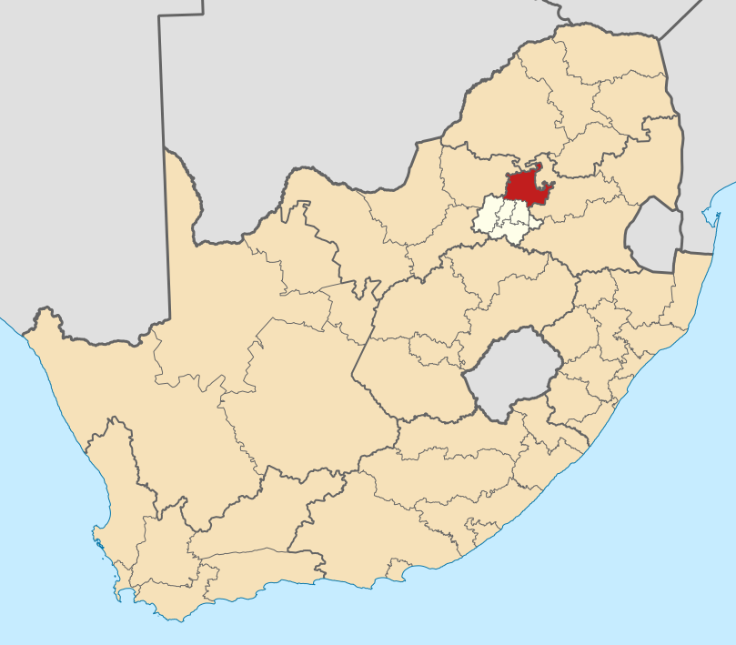
English: Map of district boundaries in South Africa, as they will be after the municipal elections of 18 May 2011, with the City of Tshwane Metropolitan Municipality highlighted in red within Gauteng in yellow. |
| Date | |
| Source | Own work |
| Author | Htonl |
Licensing
I, the copyright holder of this work, hereby publish it under the following licenses:

|
Permission is granted to copy, distribute and/or modify this document under the terms of the GNU Free Documentation License, Version 1.2 or any later version published by the Free Software Foundation; with no Invariant Sections, no Front-Cover Texts, and no Back-Cover Texts. A copy of the license is included in the section entitled GNU Free Documentation License. |
This file is licensed under the Creative Commons Attribution-Share Alike 4.0 International, 3.0 Unported, 2.5 Generic, 2.0 Generic and 1.0 Generic license.
- You are free:
- to share – to copy, distribute and transmit the work
- to remix – to adapt the work
- Under the following conditions:
- attribution – You must give appropriate credit, provide a link to the license, and indicate if changes were made. You may do so in any reasonable manner, but not in any way that suggests the licensor endorses you or your use.
- share alike – If you remix, transform, or build upon the material, you must distribute your contributions under the same or compatible license as the original.
You may select the license of your choice.
File history
Click on a date/time to view the file as it appeared at that time.
| Date/Time | Thumbnail | Dimensions | User | Comment | |
|---|---|---|---|---|---|
| current | 20:19, 2 May 2011 | | 809 × 709 (467 KB) | Htonl | == Summary == {{Information |Description ={{en|1=Map of district boundaries in South Africa, as they will be after the municipal elections of 18 May 2011, with the [[w:City of Tshwane Metropolitan Municipali |
File usage
More than 100 pages use this file. The following list shows the first 100 pages that use this file only. A full list is available.
- Akasia
- Amandasig
- Arcadia, Pretoria
- Atteridgeville
- Booysens, Pretoria
- Bronkhorstspruit
- Brooklyn, Pretoria
- Capital Park, Pretoria
- Centurion, South Africa
- Chantelle, Pretoria
- City of Tshwane Metropolitan Municipality
- Clubview
- Constantia Park
- Cornwall Hill
- Cullinan, South Africa
- Danville, Pretoria
- Die Wilgers
- Doringkloof
- Eastwood, Pretoria
- Eersterust
- Ekangala
- Elardus Park
- Eldoraigne
- Equestria, Pretoria
- Erasmia
- Erasmuskloof
- Faerie Glen
- Ga-Rankuwa
- Garsfontein
- Groenkloof
- Hammanskraal
- Hatfield, Pretoria
- Hazelwood, Pretoria
- Heuweloord
- Irene, Gauteng
- Kameeldrift
- Karenpark
- Kleinfontein
- Kloofsig
- Lady Selborne, Pretoria
- Laudium
- Lotus Gardens
- Lukasrand
- Lynnwood, Pretoria
- Lynnwood Glen
- Lynnwood Manor
- Lynnwood Ridge
- Lyttelton, Gauteng
- Mabopane
- Magalieskruin
- Mamelodi
- Marabastad, Pretoria
- Mayville, Pretoria
- Menlo Park, Pretoria
- Montana Park
- Monument Park, Pretoria
- Moreleta Park
- Murrayfield, Pretoria
- Newlands, Pretoria
- Nuwe Eersterus
- Olievenhoutbosch
- Onderstepoort
- Onverwacht, Gauteng
- Pierre van Ryneveld Park
- Pretoria
- Pretoria North
- Pretoria West
- Prinshof
- Queenswood
- Rayton
- Refilwe
- Rooihuiskraal
- Roseville, Pretoria
- Rosslyn, South Africa
- Saulsville
- Shere, Pretoria
- Silver Lakes, Pretoria
- Silverton, Pretoria
- Sinoville, Pretoria
- Soshanguve
- Sunderland Ridge
- Sunnyside, Pretoria
- Temba, South Africa
- The Orchards, Gauteng
- The Reeds
- Theresapark
- Villieria
- Wapadrand
- Waterkloof
- Waterkloof Glen
- Waterkloof Park
- Waterkloof Ridge
- Waverley, Pretoria
- Wingate Park
- Wonderboom, Pretoria
- Wonderboom South, Pretoria
- Zithobeni
- Zwartkop
- User:Coenie.Richards/sandbox
- User:Drmk101
View more links to this file.
Global file usage
The following other wikis use this file:
- Usage on af.wikipedia.org
- Pretoria
- Centurion
- Cullinan
- Marabastad
- Brooklyn, Pretoria
- Waterkloof
- Groenkloof
- Hatfield, Pretoria
- Arcadia, Pretoria
- Elarduspark
- Irene
- Bronkhorstspruit
- Valhalla
- Kleinfontein
- Mabopane
- Atteridgeville
- Capital Park
- Hammanskraal
- Rayton
- Die Wilgers
- Winterveld
- Rietfontein, Pretoria
- Highveld
- Erasmuskloof
- Wingate Park
- Pierre van Ryneveldpark
- Moreletapark
- Monument Park
- Waterkloofrif
- Menlopark, Pretoria
- Kloofsig
- Lyttelton
- Constantiapark
- Lynnwood
- Olievenhoutbosch
- Ga-Rankuwa
- Mamelodi
- Soshanguve
- Akasia
- Temba
- Chantelle
- Orchards, Pretoria
- Pretoria-Noord
- Rosslyn
- Laudium
- Lyttelton Manor
- Doringkloof
- Villieria
- Waverley
- Garsfontein
View more global usage of this file.
.svg)