
Size of this preview: 606 × 600 pixels. Other resolutions: 242 × 240 pixels | 485 × 480 pixels | 776 × 768 pixels | 1,034 × 1,024 pixels | 2,069 × 2,048 pixels | 5,448 × 5,394 pixels.
Original file (5,448 × 5,394 pixels, file size: 3.82 MB, MIME type: image/jpeg)
Summary
| Description |
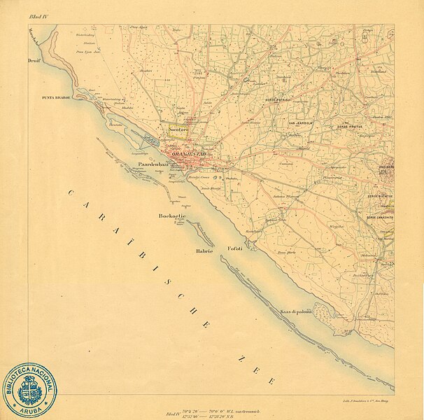
Nederlands: Topographische Kaart van Aruba (1912) - Blad IV Werbata-Jonckheer |
||||||||||||||||||||
| Map legend | Anna Mientje, Babijn, Baca Morto, Benificencia (Kerkhof), Bloemand, Boekoetie, Buena Vista, Bushiri, Canashito, Casibari, Cumana, Dakota, Doorkas, Druif, Falcon, Fofoti, Gascogne, Gasparitoe, Habrie, Hato, Heintje Croes, Hooiberg, Kaas di Paloma, Kamakoeri, Lagoen, Madiki, Mahoema, Manchebo, Meiveld, Mon Plaisir, Morgenster, Nune, Oranjestad, Paardenbaai, Paradera, Perkietenbosch, Piedra Plat, Plantersrust, Ponton, Poos Abau, Poos Sjon Jan, Punta Braboe, Rancho, Roncado, Sabana Blancoe, Sabana Verde, San Barbola, Santa Helena, Santoe, Seroe Bientoe, Seroe Blanco, Seroe Canashito, Seroe Patrisji, Shiribana, Sividivi, Socotoro, Solito, Solito, Sta. Martha, Sta. Rosa, Tanki Leendert, Tanki Schipau, Taratata, Waijaka | ||||||||||||||||||||
| Date | |||||||||||||||||||||
| Source | Biblioteca Nacional Aruba | ||||||||||||||||||||
| Creator |
Werbata, Johannes Vallentin Dominicus; Jonckheer, Willem A. |
||||||||||||||||||||
| Geotemporal data | |||||||||||||||||||||
| Map location | Aruba | ||||||||||||||||||||
| Scale | 1:20 000 | ||||||||||||||||||||
| Bibliographic data | |||||||||||||||||||||
| Map sheet | IV | ||||||||||||||||||||
| Archival data | |||||||||||||||||||||
| Collection |
|
||||||||||||||||||||
| Accession number |
BNA-DIG-WERBATA-004 |
||||||||||||||||||||
| Notes | Topographische Kaart van Aruba / [triangulatie J.J. Beaujon, R.J. Beaujon en L. Lens, 1904-1909, terreinopname W.A. Jonckheer 1909-1911]. - Schaal 1:20.000. - Den Haag: Lith. J. Smulders & Co., [1912]. - 1 kaartserie in 8 bladen: in kleur; 47 x 46 cm per blad. | ||||||||||||||||||||
| Other versions |
|
||||||||||||||||||||


See all parts of this map: https://coleccion.aw/browse/?q=BNA-DIG-WERBATA
Licensing
This file is licensed under the Creative Commons Attribution-Share Alike 4.0 International license.
- You are free:
- to share – to copy, distribute and transmit the work
- to remix – to adapt the work
- Under the following conditions:
- attribution – You must give appropriate credit, provide a link to the license, and indicate if changes were made. You may do so in any reasonable manner, but not in any way that suggests the licensor endorses you or your use.
- share alike – If you remix, transform, or build upon the material, you must distribute your contributions under the same or compatible license as the original.
File history
Click on a date/time to view the file as it appeared at that time.
| Date/Time | Thumbnail | Dimensions | User | Comment | |
|---|---|---|---|---|---|
| current | 14:58, 6 June 2023 | | 5,448 × 5,394 (3.82 MB) | Kallmemel | Uploaded a work by Werbata, Johannes Vallentin Dominicus; Jonckheer, Willem A. from https://coleccion.aw/show/?BNA-DIG-WERBATA-004 with UploadWizard |
File usage
The following pages on the English Wikipedia use this file (pages on other projects are not listed):
Global file usage
The following other wikis use this file:
- Usage on nl.wikipedia.org
- Usage on pap.wikipedia.org