Angalakuduru | |
|---|---|
Suburb, Area of Tenali | |
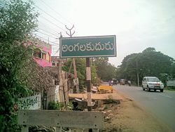
 Signboard of Angalakuduru village | |
 Dynamic map | |
| Coordinates: 16°14′21″N 80°36′42″E / 16.23917°N 80.61167°E | |
| Country | India |
| State | Andhra Pradesh |
| District | Guntur |
| Mandal | Tenali |
| Seat | Angalakuduru Gram Panchayat |
| Wards | 14 |
| Government | |
| • Type | Panchayati raj |
| • Body | Angalakuduru Gram Sabha |
| • Sarpanch | Vacant |
| Area | |
| • Total | 911 ha (2,251 acres) |
| Population (2011)[3] | |
| • Total | 9,920 |
| • Density | 1,100/km2 (2,800/sq mi) |
| Languages | |
| • Official | Telugu |
| Time zone | UTC+5:30 (IST) |
| PIN | 522211 |
| Area code | +918644 |
| Vehicle registration | AP |
Angalakuduru is an area of Tenali in Guntur district of the Indian state of Andhra Pradesh. It is located in Tenali mandal of Tenali revenue division. It is a residential area in Tenali.[2][4] It forms a part of Andhra Pradesh Capital Region.[5]
Geography[edit]
Angalakuduru is situated to the west of Tenali,[6] at 16°14′21″N 80°36′42″E / 16.23917°N 80.61167°E.
Demographics[edit]
As of 2011[update] Census of India, Angalakuduru had a population of 9920. A sex ratio of 1059 females per 1000 males. The average literacy rate stands at 77.75% with 7,088 literates, significantly higher than the state average of 67.41%.[3][7]
Government and politics[edit]
Angalakuduru gram panchayat is the local self-government of the village.[1] There are 20 wards, each represented by an elected ward member. The present sarpanch is vacant, elected indirectly by the ward members.[8] The village is administered by the Tenali Mandal Parishad at the intermediate level of panchayat raj institutions.[6]
Economy[edit]
Agriculture is the main occupation of the village and the main crops been cultivated are paddy, maize, black gram etc.[9] Apart from it, small scale occupations produce weaved baskets, bags, mats etc., from water hyacinth.[10][11]
Transport[edit]
Angalakuduru has road and rail connectivity. It lies on the Guntur–Tenali road passing through the village.[12][13] Angalakuduru railway station is an F–category station on Guntur–Tenali section and is administered under Guntur railway division of South Central Railway zone.[14]

The nearest railway station to Angalakuduru village are Angalakuduru Railway station and Tenali junction railway station. The village is well connected to Tenali city . Angalakuduru is at a distance of 3 km from Tenali. According to 2011 In the Tenali City expansion the Angalakuduru village was present.
Education[edit]
The primary and secondary school education is imparted by government, aided and private schools, under the School Education Department of the state.[15][16] The total number of students enrolled in primary, upper primary and high schools in the village are 1,471.[17] VSR and JDM Zilla Parishad High School is a Zilla Parishad funded school, which provides secondary education in the village.[18]
See also[edit]
References[edit]
- ^ a b "Gram Panchayat Identification Codes" (PDF). Saakshar Bharat Mission. National Informatics Centre. p. 120. Archived from the original (PDF) on 18 August 2017. Retrieved 7 May 2019.
- ^ a b "District Census Handbook : Guntur" (PDF). Census of India. Registrar General and Census Commissioner of India. pp. 14, 488. Retrieved 7 May 2019.
- ^ a b "Population". Census of India. Registrar General and Census Commissioner of India. Retrieved 8 May 2019.
- ^ "District Level Mandal wise List of Villages in Andhra Pradesh" (PDF). Chief Commissioner of Land Administration. National Informatics Centre. p. 11. Archived from the original (PDF) on 14 December 2014. Retrieved 19 September 2015.
- ^ "Declaration of A.P. Capital Region" (PDF). Andhra Pradesh Capital Region Development Authority. Municipal Administration and Urban Development Department, Andhra Pradesh. 30 December 2014. p. 4. Archived from the original (PDF) on 11 May 2019. Retrieved 17 May 2019.
- ^ a b "District Census Handbook : Guntur" (PDF). Census of India. Registrar General and Census Commissioner of India. pp. 650–651. Retrieved 31 May 2019.
- ^ "Literacy of AP (Census 2011)" (PDF). Official Portal of Andhra Pradesh Government. p. 43. Archived from the original (PDF) on 14 July 2014. Retrieved 5 September 2014.
- ^ Mathew, George; Sciences, Institute of Social (1995). Status of Panchayati Raj in the States of India, 1994. Concept Publishing Company. pp. 19, 78. ISBN 9788170225539. Retrieved 31 May 2019.
- ^ Susarla, Ramesh (17 December 2009). "Tenant farmers in Guntur district the worst-affected". The Hindu. Guntur. Retrieved 11 March 2016.
- ^ Samuel, Jonathan (25 August 2015). "Making the most out of water weed". The Hindu. Tenali. Retrieved 11 March 2016.
- ^ "Working his brains through art and craft from water hyacinth". Deccan Chronicle. Hyderabad. 23 May 2017. Retrieved 17 May 2019.
- ^ "Tenali Zonal Development Plan" (PDF). Andhra Pradesh Capital Region Development Authority. Government of Andhra Pradesh. Archived from the original (PDF) on 19 April 2016. Retrieved 8 May 2016.
- ^ A Manual of the Kistna District, in the Presidency of Madras: Compiled for the Government of Madras. Lawrence Asylum Press. 1 January 1883. p. 213.
- ^ "Evolution of Guntur Division" (PDF). South Central Railway. p. 11. Retrieved 3 May 2016.
- ^ "School Education Department" (PDF). School Education Department, Government of Andhra Pradesh. Archived from the original (PDF) on 27 December 2015. Retrieved 7 November 2016.
- ^ "The Department of School Education – Official AP State Government Portal | AP State Portal". www.ap.gov.in. Archived from the original on 7 November 2016. Retrieved 7 November 2016.
- ^ "Student Information Report". Commissionerate of School Education. Child info 2015–16, District School Education – Andhra Pradesh. Retrieved 8 November 2016.
- ^ "List of High Schools" (PDF). Sakshi Education. Retrieved 5 May 2016.
