→Hurricane Dalila: advisory 15 |
AndrewPeterT (talk | contribs) m add the time when Dalila became a hurricane |
||
| Line 201: | Line 201: | ||
}} |
}} |
||
--> |
--> |
||
During the afternoon hours of June 26, the National Hurricane Center began monitoring a newly formed area of disturbed weather located several hundred miles south of [[Acapulco|Acapulco, Mexico]].<ref>{{cite web|author=John L. Beven II|title=Graphical Tropical Weather Outlook|url=http://www.nhc.noaa.gov/archive/gtwo/epac/201306261743/index.php?basin=epac¤t_issuance=201306261743|publisher=National Hurricane Center|date=June 26, 2013|accessdate=June 30, 2013}}</ref> At the time, upper-level winds were not conducive for organization and the large area of shower and thunderstorm activity remained disorganized accordingly.<ref>{{cite web|author=Todd B. Kimberlain|title=Graphical Tropical Weather Outlook|url=http://www.nhc.noaa.gov/archive/gtwo/epac/201306262348/index.php?basin=epac¤t_issuance=201306262348|publisher=National Hurricane Center|date=June 26, 2013|accessdate=June 30, 2013}}</ref> As shear slowly lowered, gradual consolidation of the system occurred, and the NHC assessed the disturbance with a medium chance of tropical cyclone formation within 48 hours.<ref>{{cite web|author=Richard J. Pasch|title=Graphical Tropical Weather Outlook|url=http://www.nhc.noaa.gov/archive/gtwo/epac/201306280600/index.php?basin=epac¤t_issuance=201306280600|publisher=National Hurricane Center|date=June 27, 2013|accessdate=June 30, 2013}}</ref> Convection decreased in coverage and intensity the following day, but a burst in shower and thunderstorm activity the following morning led to the formation of Tropical Depression Four-E at 0300 UTC on June 30, while situated 375 mi (605 km) south-southeast of [[Manzanillo, Colima|Manzanillo, Mexico]].<ref>{{cite report|author=Eric S. Blake|title=Tropical Depression Four-E Public Advisory Number 1|url=http://www.nhc.noaa.gov/archive/2013/ep04/ep042013.public.001.shtml|publisher=National Hurricane Center|date=June 29, 2013|accessdate=June 30, 2013}}</ref> Though the system did not become inherently better organized, a relocation of the low-level center further within the convective mass prompted the NHC to upgrade Four-E to Tropical Storm Dalila several hours later.<ref>{{cite report|author=Lixion A. Avila|title=Tropical Storm Dalila Public Advisory Number 2|url=http://www.nhc.noaa.gov/archive/2013/ep04/ep042013.public.002.shtml|publisher=National Hurricane Center|date=June 30, 2013|accessdate=June 30, 2013}}</ref> Slight wind shear from an upper-level [[Trough (meteorology)|trough]] in close proximity to the system caused it to become less organized early on June 30; the storm, however, was still expected to strengthen over the following days.<ref>{{cite report|author=Richard J. Pasch|title=Tropical Storm Dalila Public Advisory Number 2|url=http://www.nhc.noaa.gov/archive/2013/ep04/ep042013.discus.004.shtml|publisher=National Hurricane Center|date=June 30, 2013|accessdate=June 30, 2013}}</ref> Convection improved in organization late that evening, and an open mid-level [[Eye (cyclone)|eye]] was observed on microwave imagery. A prominent rain band became visible early on July 1, marking continued intensification. |
During the afternoon hours of June 26, the National Hurricane Center began monitoring a newly formed area of disturbed weather located several hundred miles south of [[Acapulco|Acapulco, Mexico]].<ref>{{cite web|author=John L. Beven II|title=Graphical Tropical Weather Outlook|url=http://www.nhc.noaa.gov/archive/gtwo/epac/201306261743/index.php?basin=epac¤t_issuance=201306261743|publisher=National Hurricane Center|date=June 26, 2013|accessdate=June 30, 2013}}</ref> At the time, upper-level winds were not conducive for organization and the large area of shower and thunderstorm activity remained disorganized accordingly.<ref>{{cite web|author=Todd B. Kimberlain|title=Graphical Tropical Weather Outlook|url=http://www.nhc.noaa.gov/archive/gtwo/epac/201306262348/index.php?basin=epac¤t_issuance=201306262348|publisher=National Hurricane Center|date=June 26, 2013|accessdate=June 30, 2013}}</ref> As shear slowly lowered, gradual consolidation of the system occurred, and the NHC assessed the disturbance with a medium chance of tropical cyclone formation within 48 hours.<ref>{{cite web|author=Richard J. Pasch|title=Graphical Tropical Weather Outlook|url=http://www.nhc.noaa.gov/archive/gtwo/epac/201306280600/index.php?basin=epac¤t_issuance=201306280600|publisher=National Hurricane Center|date=June 27, 2013|accessdate=June 30, 2013}}</ref> Convection decreased in coverage and intensity the following day, but a burst in shower and thunderstorm activity the following morning led to the formation of Tropical Depression Four-E at 0300 UTC on June 30, while situated 375 mi (605 km) south-southeast of [[Manzanillo, Colima|Manzanillo, Mexico]].<ref>{{cite report|author=Eric S. Blake|title=Tropical Depression Four-E Public Advisory Number 1|url=http://www.nhc.noaa.gov/archive/2013/ep04/ep042013.public.001.shtml|publisher=National Hurricane Center|date=June 29, 2013|accessdate=June 30, 2013}}</ref> Though the system did not become inherently better organized, a relocation of the low-level center further within the convective mass prompted the NHC to upgrade Four-E to Tropical Storm Dalila several hours later.<ref>{{cite report|author=Lixion A. Avila|title=Tropical Storm Dalila Public Advisory Number 2|url=http://www.nhc.noaa.gov/archive/2013/ep04/ep042013.public.002.shtml|publisher=National Hurricane Center|date=June 30, 2013|accessdate=June 30, 2013}}</ref> Slight wind shear from an upper-level [[Trough (meteorology)|trough]] in close proximity to the system caused it to become less organized early on June 30; the storm, however, was still expected to strengthen over the following days.<ref>{{cite report|author=Richard J. Pasch|title=Tropical Storm Dalila Public Advisory Number 2|url=http://www.nhc.noaa.gov/archive/2013/ep04/ep042013.discus.004.shtml|publisher=National Hurricane Center|date=June 30, 2013|accessdate=June 30, 2013}}</ref> Convection improved in organization late that evening, and an open mid-level [[Eye (cyclone)|eye]] was observed on microwave imagery. A prominent rain band became visible early on July 1, marking continued intensification. Dalila began to weaken on July 2, but it abruptly became a hurricane that same day. <ref>{{cite report|author=Eric S. Blake|title=Tropical Depression Four-E Public Advisory Number 1|url=http://www.nhc.noaa.gov/archive/2013/ep04/ep042013.public.001.shtml|publisher=National Hurricane Center|date=June 29, 2013|accessdate=June 30, 2013}}</ref> Though the system did not become inherently better organized, a relocation of the low-level center further within the convective mass prompted the NHC to upgrade Four-E to Tropical Storm Dalila several hours later.<ref>{{cite report|author=Richard Pasch|title=Hurricane Dalila Public Advisory Number 12|url=http://www.nhc.noaa.gov/archive/2013/ep04/ep042013.public.012.shtml?|publisher=National Hurricane Center|date=July 2, 2013|accessdate=July 3, 2013}}</ref> |
||
====Current storm information==== |
====Current storm information==== |
||
Revision as of 11:33, 3 July 2013
| 2013 Pacific hurricane season | |
|---|---|
 Season summary map | |
| Seasonal boundaries | |
| First system formed | May 15, 2013 |
| Last system dissipated | Season still active |
| Strongest storm | |
| Name | Cosme |
| • Maximum winds | 85 mph (140 km/h) |
| • Lowest pressure | 981 mbar (hPa; 28.97 inHg) |
| Seasonal statistics | |
| Total depressions | 4 |
| Total storms | 4 |
| Hurricanes | 3 |
| Major hurricanes (Cat. 3+) | 0 |
| Total fatalities | 7 confirmed, 4 missing |
| Total damage | $1 million (2013 USD) |
| Related article | |
The 2013 Pacific hurricane season was only the fourth Pacific hurricane season to have two storms form in May. The season officially began on May 15, 2013 in the Eastern Pacific and started on June 1, 2013 in the Central Pacific. Both will end on November 30, 2013. These dates conventionally delimit the period of each year when most tropical cyclones form in the eastern Pacific basin. However, the formation of tropical cyclones is possible at any time.
The most notable storm thus far this year was Hurricane Barbara, which brought widespread heavy rains to much of Southwestern Mexico and Central America. Damage estimates from the storm range from $750,000 to $1 million (2013 USD); four people were killed and four others are reportedly missing.
Seasonal forecasts
| Source | Date | Named storms |
Hurricanes | Major hurricanes | |
| Average (1971–2006) | 15.3 | 8.8 | 4.2 | ||
| Record high activity | 28 | 16 (tie) | 10 | ||
| Record low activity | 8 (tie) | 3 | 0† (tie) | ||
| ––––––––––––––––––––––––––––––––––––––––––––––––––––––– | |||||
| NOAA | May 23, 2013 | 11-16 | 5-8 | 1-4 | |
| ––––––––––––––––––––––––––––––––––––––––––––––––––––––– | |||||
| Actual activity |
4 | 3 | 0 | ||
On May 22, National Oceanic and Atmospheric Administration’s Central Pacific Hurricane Center announced a below-normal season in the Central Pacific warning zone this year. The outlook calls for a 70 percent chance of a below-normal season, a 25 percent chance of a near-normal season, and a 5 percent chance of an above-normal season. 1 to 3 tropical cyclones to affect the central Pacific this season. On average, 4 to 5 tropical cyclones either form in or enter the warning zone. The main reason for below-normal activity was due to a combination of neutral El Niño–Southern Oscillation conditions and the fact that the region was in a low phase of a Pacific Decadal Oscillation, which is known to suppress activity in the region. Despite this, meteorologists advised all residents of the Hawaiian Island group to be prepared for the upcoming hurricane season.[1]
Seasonal summary
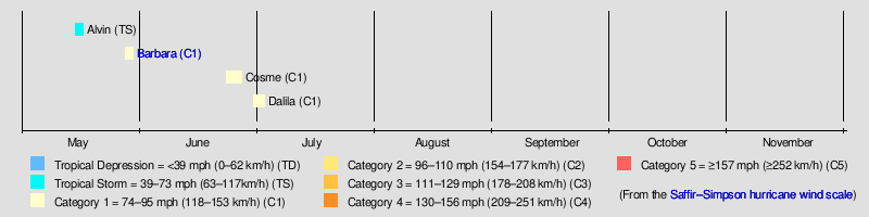
The season's first tropical storm formed on May 15,[2] coinciding with the official start of the Pacific hurricane season.[3] On average, a tropical cyclone develops in May in the eastern Pacific every other year; however, the last Pacific hurricane season to not feature at least one tropical cyclone in May was the 2011 season.[4] The formation of Barbara in late May marked only the fifth time since 1949 that two tropical storms formed during the month, with the other seasons being 1956, 1984, 2007, and 2012.[5][6][7] The Accumulated Cyclone Energy (ACE) for the season thus far is 9.5975.[nb 1]
Storms
Tropical Storm Alvin
| Tropical storm (SSHWS) | |
  | |
| Duration | May 15 – May 17 |
|---|---|
| Peak intensity | 50 mph (85 km/h) (1-min); 1003 mbar (hPa) |
A weak low-pressure area embedded within the monsoon trough of the intertropical convergence zone (ITCZ) was monitored off the west coast of Costa Rica.[8] Moving westward, the low intensified, and developed a broad atmospheric circulation late on May 14;[9] meteorologists subsequently noted moderate potential for the storm to develop into a tropical cyclone[10] At 1500 UTC on May 15, the NHC initiated advisories on Tropical Depression One-E, at the time situated 650 mi (1,045 km) south-southwest of Acapulco, Mexico.[11] The disturbance organized quickly and was upgraded to Tropical Storm Alvin roughly six hours later.[2] Initially forecast to intensify an upper-end 90 mph (145 km/h)* Category 1 hurricane,[12] the tropical storm peaked in intensity at 0900 UTC on May 16, with maximum sustained winds of 50 mph (85 km/h) and a minimum barometric pressure of 1003 mbar (29.62 inHg) instead.[13]
After Alvin attained its peak intensity, the storm's close proximity to the ITCZ caused it to become less organized as the low-level center of circulation became increasingly difficult to locate.[14] According to the NHC, Alvin degenerated into an open trough by 0900 UTC on May 17.[15] Although moderate to strong thunderstorms briefly reformed east of the remnant's center,[16] they quickly decreased on May 20.[17][18] The remnants of Alvin were last monitored by the NHC on May 24, as they had moved out the NHC area of responsibility and into CPHC's warning zone.[19]
Hurricane Barbara
| Category 1 hurricane (SSHWS) | |
  | |
| Duration | May 28 – May 30 |
|---|---|
| Peak intensity | 75 mph (120 km/h) (1-min); 990 mbar (hPa) |
A low pressure area meandered along the East Pacific region for a few days in late May. The system then managed to gain latitude as it moved through the northeast, along the Gulf of Tehuantepec.[20] Steadily organizing, the system was declared Tropical Depression Two-E at 2100 UTC on May 28, while located about 165 mi (265 km) south-southwest of Salina Cruz, Mexico.[21] The depression strengthened and was upgraded to Tropical Storm Barbara at 0000 UTC on the following day.[22] Initially expected to remain a tropical storm before landfall, Barbara had been trying to form an eye, and based on microwave imageries, an eyewall was trying to form. Further deepening and organization occurred, with an eye already visible on satellite, and a partial eyewall already present, and Barbara was upgraded to a hurricane at 1800 UTC May 29.[23] A few hours after reaching hurricane status, the eye of the hurricane made landfall in Chiapas.[24] Immediately after making landfall, Barbara was affected by the high terrains of Southern Mexico, and it weakened to a tropical storm a few hours after landfall[25] and was declared a depression on May 30.[26] The last advisory was issued by the NHC at 2100 UTC May 30.[27] The remnants of Barbara were monitored until June 1, when the remaining activity from the system finally dissipated over the Bay of Campeche.[28]
Hurricane Cosme
| Category 1 hurricane (SSHWS) | |
  | |
| Duration | June 23 – June 27 |
|---|---|
| Peak intensity | 85 mph (140 km/h) (1-min); 981 mbar (hPa) |
The National Hurricane Center began monitoring an area of low pressure embedded within the monsoon trough on June 20.[29] Unfavorable conditions limited organization initially, but a decrease in wind shear allowed for steady development.[30] Deep shower and thunderstorm activity in association with the disturbance consolidated, and the NHC assessed the low with a high chance of tropical cyclone formation within 48 hours during the afternoon hours of June 21.[31] Spiral banding became more prominent over the subsequent 24 hours, and early on June 23, the NHC determined that the system met the criteria of a tropical cyclone and initiated advisories on Tropical Depression Three-E accordingly.[32] Though the system struggled shortly after development, increasing shower and thunderstorm activity and an Advanced Scatterometer pass the following morning prompted the NHC to upgrade the system to Tropical Storm Cosme.[33] An inner core began to develop late on June 24, and Cosme intensified into a Category 1 hurricane at 1500 UTC.[34] On June 26, Cosme was downgraded back to a tropical storm as it entered the cooler waters of the Pacific Ocean, while being well off the coast of Mexico.[35]
Due to the tropical storm's large size, meteorologists at the Servicio Meteorológico Nacional noted a "moderate" hazard risk for much of southern Mexican coastline.[36] A "green" alert (low risk) was issued for the states of Colima, Jalisco and Michoacan, and a "blue" alert (minimum risk) was in effect for the states of Nayarit, Guerrero,[37] and Baja California Sur.[38] While passing through the Revillagigedo Islands, winds of 42 mph (68 km/h) were reported on Socorro Island.[39]
The outer rainband's of Cosme brought moderate rains to Guerrero,[40] causing minor flooding in Acapulco. Across the state, the storm generated 24 landslides[41] and some mudslides, which blocked highways.[40] Additionally, strong waves flooded numerous buildings.[42] Two people were killed in the state, with one being a tourist that drowned in Zihuatanejo[43] and the other a police officer in an airplane crash, which had also injured 19 people.[44] Further north, in Colima, rough seas flooded coastal towns;[45] many restaurants built of wood and coconut were damaged. In Manzanillo, some structures and many trees were downed due to strong winds while the port was closed to small craft. Moreover, one beach sustained severe damage.[46] Throughout the state, 34 tourist facilities sustained damage due to heavy waves. Another person (aged 35 to 40) was killed offshore.[47] Even further north, the port of Mazatlan was closed for small craft interests.[48]
Hurricane Dalila
| |||
|---|---|---|---|
Current storm status Category 1 hurricane (1-min mean) | |||
| |||
| As of: | 2 a.m. PDT July 3 (0900 UTC July 3) | ||
| Location: | 18°06′N 107°30′W / 18.1°N 107.5°W ± 30 nm About 220 mi (350 km) WSW of Manzanillo, Mexico | ||
| Sustained winds: | 65 knots (75 mph; 120 km/h) (1-min mean) gusting to 80 knots (90 mph; 150 km/h) | ||
| Pressure: | 987 mbar (hPa; 29.15 inHg) | ||
| Movement: | SW at 2 knots (2 mph; 4 km/h) | ||
| See more detailed information. | |||


During the afternoon hours of June 26, the National Hurricane Center began monitoring a newly formed area of disturbed weather located several hundred miles south of Acapulco, Mexico.[49] At the time, upper-level winds were not conducive for organization and the large area of shower and thunderstorm activity remained disorganized accordingly.[50] As shear slowly lowered, gradual consolidation of the system occurred, and the NHC assessed the disturbance with a medium chance of tropical cyclone formation within 48 hours.[51] Convection decreased in coverage and intensity the following day, but a burst in shower and thunderstorm activity the following morning led to the formation of Tropical Depression Four-E at 0300 UTC on June 30, while situated 375 mi (605 km) south-southeast of Manzanillo, Mexico.[52] Though the system did not become inherently better organized, a relocation of the low-level center further within the convective mass prompted the NHC to upgrade Four-E to Tropical Storm Dalila several hours later.[53] Slight wind shear from an upper-level trough in close proximity to the system caused it to become less organized early on June 30; the storm, however, was still expected to strengthen over the following days.[54] Convection improved in organization late that evening, and an open mid-level eye was observed on microwave imagery. A prominent rain band became visible early on July 1, marking continued intensification. Dalila began to weaken on July 2, but it abruptly became a hurricane that same day. [55] Though the system did not become inherently better organized, a relocation of the low-level center further within the convective mass prompted the NHC to upgrade Four-E to Tropical Storm Dalila several hours later.[56]
Current storm information
As of 2 a.m. PDT July 3 (0900 UTC July 3), Hurricane Dalila is located within 30 nautical miles of 18°06′N 107°30′W / 18.1°N 107.5°W, about 220 miles (350 km) west-southwest of Manzanillo, Mexico. Maximum sustained winds are 65 knots (75 mph, 120 km/h), with stronger gusts. The minimum central pressure is 987 mbar (hPa; 29.15 InHg), and the system is moving southwest at 2 knots (2 mph; 4 km/h). Hurricane-force winds extend outward up to 25 miles (35 km) from the center of Dalila, and tropical storm-force winds extend outward up to 70 miles (110 km) from the center.
For latest official information see:
- The NHC's latest Public Advisory on Hurricane Dalila
- The NHC's latest Forecast Discussion on Hurricane Dalila
Storm names
The following names will be used for named storms that form in the Northeastern Pacific Ocean during 2013. Retired names, if any, will be announced by the World Meteorological Organization in the spring of 2014. The names not retired from this list will be used again in the 2019 season. This is the same list used in the 2007 season.[57]
|
|
|
For storms that form in the Central Pacific Hurricane Center's area of responsibility, encompassing the area between 140 degrees west and the International Date Line, all names are used in a series of four rotating lists.[58] The next four names slated for use are shown below.
|
|
|
|
Season effects
This is a table of all of the storms that have formed in the 2013 Pacific hurricane season. It includes their duration, names, landfall(s) (in parenthesis) damages, and death totals. Deaths in parentheses are additional and indirect, but were still related to that storm. Damage and deaths include totals while the storm was extratropical, a wave, or a low, and all of the damage figures are in 2013 USD.
| Storm name |
Dates active | Storm category at peak intensity |
Max 1-min wind mph (km/h) |
Min. press. (mbar) |
Areas affected | Damage (USD) |
Deaths | Ref(s) | ||
|---|---|---|---|---|---|---|---|---|---|---|
| Alvin | May 15 – 17 | Tropical storm | 50 (85) | 1003 | None | None | None | |||
| Barbara | May 28 – May 30 | Category 1 hurricane | 75 (120) | 990 | El Salvador, Guatemala, Southwestern Mexico (Chiapas) | 1 | 4 | |||
| Cosme | June 23 – June 27 | Category 1 hurricane | 85 (140) | 981 | Southwestern Mexico | Unknown | 3 | |||
| Dalila | June 30 – Currently active | Category 1 hurricane | 75 (120) | 987 | Western Mexico | Unknown | None | |||
| Season aggregates | ||||||||||
| 4 systems | May 15 – Currently active | 85 (140) | 981 | 1 | 7 | |||||
See also
- List of Pacific hurricanes
- List of Pacific hurricane seasons
- 2013 Atlantic hurricane season
- 2013 Pacific typhoon season
- 2013 North Indian Ocean cyclone season
- South-West Indian Ocean cyclone seasons: 2012–13, 2013–14
- Australian region cyclone seasons: 2012–13, 2013–14
- South Pacific cyclone seasons: 2012–13, 2013–14
Notes
- ^ The totals represent the sum of the squares for every tropical storm's intensity of over 33 knots (38 mph, 61 km/h), divided by 10,000. Calculations are provided at Talk:2013 Pacific hurricane season/ACE calcs.
References
- ^ "NOAA expects below-normal Central Pacific hurricane season". NOAA. Retrieved 23 May 2013.
- ^ a b Robbie J. Berg (May 15, 2013). Tropical Storm Alvin Discussion Number 2 (Report). National Hurricane Center. Retrieved May 15, 2013.
- ^ National Hurricane Center (May 2, 2013). "Tropical Cyclone Climatology". United States National Oceanic and Atmospheric Administration. Retrieved May 23, 2013.
- ^ Hurricane Specialist Unit (June 1, 2011). Monthly Tropical Weather Summary (Report). National Hurricane Center. Retrieved May 23, 2013.
- ^ Hurricane Specialist Unit (June 1, 2013). "Monthly Tropical Weather Summary" (TXT). National Hurricane Center. Retrieved June 30, 2013.
- ^ Hurricane Specialist Unit (June 1, 2012). Monthly Tropical Weather Summary (TXT) (Report). National Hurricane Center. Retrieved June 30, 2013.
- ^ Hurricane Specialist Unit (June 1, 2007). Monthly Tropical Weather Summary (TXT) (Report). National Hurricane Center. Retrieved June 30, 2013.
- ^ Dave Sandoval (May 12, 2013). Tropical Weather Discussion (Report). National Hurricane Center. Retrieved May 18, 2013.
- ^ Jeffrey Lewitsky (May 14, 2013). Tropical Weather Discussion (Report). National Hurricane Center. Retrieved May 18, 2013.
- ^ John Cangialosi (May 12, 2013). Special Graphical Tropical Weather Outlook (Report). National Hurricane Center. Retrieved May 18, 2013.
- ^ Robbie J. Berg (May 15, 2013). Tropical Depression One-E Discussion Number 1 (Report). National Hurricane Center. Retrieved May 15, 2013.
- ^ Robbie J. Berg (May 15, 2013). Tropical Storm Alvin Discussion Number 2 (Report). National Hurricane Center. Retrieved May 18, 2013.
- ^ Eric S. Blake (May 16, 2013). Tropical Storm Alvin Discussion Number 4 (Report). National Hurricane Center. Retrieved May 16, 2013.
- ^ Robbie J. Berg (May 16, 2013). Tropical Storm Alvin Discussion Number 5 (Report). National Hurricane Center. Retrieved May 16, 2013.
- ^ Eric Blake (May 17, 2013). Post-Tropical Cyclone Alvin Discussion Number 8 (Report). National Hurricane Center. Retrieved May 17, 2013.
- ^ John Cangialosi (May 18, 2013). "Tropical Weather Outlook". National Hurricane Center. Retrieved May 18, 2013.
- ^ John L. Cangialosi (May 19, 2013). Tropical Weather Outlook (Report). National Hurricane Center. Retrieved May 23, 2013.
- ^ John L. Cangialosi (May 20, 2013). Tropical Weather Outlook (Report). National Hurricane Center. Retrieved May 20, 2013.
- ^ Gladys Rubio; Eric Christensen (May 24, 2013). Tropical Weather Discussion (Report). National Hurricane Center. Retrieved May 25, 2013.
- ^ Daniel P. Brown (May 24, 2013). Graphical Tropical Weather Outlook (Report). National Hurricane Center. Retrieved May 24, 2013.
- ^ John P. Cangialosi; Richard J. Pasch (May 28, 2013). Tropical Depression Two-E Discussion Number 1 (Report). National Hurricane Center. Retrieved May 29, 2013.
- ^ Robbie J. Berg; John L. Beven II (May 29, 2013). Tropical Storm Barbara Intermediate Advisory Number 1A (Report). National Hurricane Center. Retrieved May 29, 2013.
- ^ Richard J. Pasch; Christopher W. Landsea (May 29, 2013). Hurricane Barbara Intermediate Advisory Number 5A (Report). National Hurricane Center. Retrieved May 29, 2013.
- ^ Richard J. Pasch; Robbie J.Berg (May 29, 2013). Hurricane Barbara Tropical Cyclone Update (Report). National Hurricane Center. Retrieved May 29, 2013.
- ^ John L. Beven II; Robbie J.Berg (May 29, 2013). Hurricane Barbara Intermediate Advisory 6A (Report). National Hurricane Center. Retrieved May 29, 2013.
- ^ John L. Beven II; Robbie J.Berg (May 29, 2013). Hurricane Barbara Intermediate Advisory 6A (Report). National Hurricane Center. Retrieved May 30, 2013.
- ^ Richard J. Pasch; Robbie J.Berg (May 29, 2013). Hurricane Barbara Tropical Cyclone Update (Report). National Hurricane Center. Retrieved May 30, 2013.
- ^ John L. Beven II (June 1, 2013). Graphical Tropical Weather Outlook (Report). National Hurricane Center. Retrieved June 1, 2013.
- ^ Todd B. Kimberlain (June 20, 2013). "Graphical Tropical Weather Outlook". National Hurricane Center. Retrieved June 25, 2013.
- ^ Eric S. Blake (June 20, 2013). "Graphical Tropical Weather Outlook". National Hurricane Center. Retrieved June 25, 2013.
- ^ John L. Beven II (June 21, 2013). "Graphical Tropical Weather Outlook". National Hurricane Center. Retrieved June 25, 2013.
- ^ Eric S. Blake (June 23, 2013). Tropical Depression Three-E Discussion Number 1 (Report). National Hurricane Center. Retrieved June 25, 2013.
- ^ Stacy R. Stewart (June 23, 2013). Tropical Storm Cosme Discussion Number 4 (Report). National Hurricane Center. Retrieved June 25, 2013.
- ^ John L. Beven (June 23, 2013). Hurricane Cosme Discussion Number 9 (Report). National Hurricane Center. Retrieved June 25, 2013.
- ^ The Associated Press (June 6, 2013). Tropical Storm Cosme continues to weaken in Pacific off coast of Mexico; poses no land threat (Report). Retrieved June 26,2013.
{{cite report}}: Check date values in:|accessdate=(help) - ^ Template:Es icon "Prevén lluvias en 5 estados por tormenta Cosme". El Universal. June 24, 2013. Retrieved June 24, 2013.
- ^ Template:Es icon"Cosme se fortalece y se aleja de costas mexicanas". El Universal. July 25, 2013. Retrieved July 25, 2013.
- ^ Template:Es icon "BCS decreta alerta azul por huracán Cosme". El Universal. June 25, 2103. Retrieved June 26, 2013.
{{cite news}}: Check date values in:|date=(help) - ^ Template:Es icon "Ya como huracán, "Cosme" se aleja de México". La Prensa. Organización Editorial Mexicana. June 25, 2013. Retrieved June 26, 2013.
- ^ a b Template:Es icon "Guerrero alerta por lluvias generadas por Cosme". El Universal. June 24, 2013. Retrieved June 24, 2013.
- ^ Template:Es icon "Deja dos muertos huracán "Cosme" en Guerrero". Xeu. June 25, 2013. Retrieved June 26, 2013.
- ^ Template:Es icon "Volcán de Colima registra 'deslaves' por lluvia". El Universal. June 25, 2013. Retrieved June 25, 2013.
- ^ Template:Es icon "Huracán Cosme deja dos muertos en Guerrero". El Universal. June 25, 2013. Retrieved June 25, 2013.
- ^ Template:Es icon "Huracán Cosme provoca muerte de policía en Guerrero". Red Noticier. June 26, 2013. Retrieved June 26, 2013.
- ^ Template:Es icon "Huracán 'Cosme' causa lluvias en Colima: SMN". La Jarnada. June 25, 2013. Retrieved June 25, 2013.
- ^ "Cosme daña restaurantes de playa en Colima". El Universal. June 26, 2013. Retrieved June 26, 2013.
- ^ "Aumentan daños en playas de Colima por Cosme". June 29, 2013.
- ^ "Mazatlan port close by Cosme effects". El Universal. June 26, 2013. Retrieved June 29, 2013.
- ^ John L. Beven II (June 26, 2013). "Graphical Tropical Weather Outlook". National Hurricane Center. Retrieved June 30, 2013.
- ^ Todd B. Kimberlain (June 26, 2013). "Graphical Tropical Weather Outlook". National Hurricane Center. Retrieved June 30, 2013.
- ^ Richard J. Pasch (June 27, 2013). "Graphical Tropical Weather Outlook". National Hurricane Center. Retrieved June 30, 2013.
- ^ Eric S. Blake (June 29, 2013). Tropical Depression Four-E Public Advisory Number 1 (Report). National Hurricane Center. Retrieved June 30, 2013.
- ^ Lixion A. Avila (June 30, 2013). Tropical Storm Dalila Public Advisory Number 2 (Report). National Hurricane Center. Retrieved June 30, 2013.
- ^ Richard J. Pasch (June 30, 2013). Tropical Storm Dalila Public Advisory Number 2 (Report). National Hurricane Center. Retrieved June 30, 2013.
- ^ Eric S. Blake (June 29, 2013). Tropical Depression Four-E Public Advisory Number 1 (Report). National Hurricane Center. Retrieved June 30, 2013.
- ^ Richard Pasch (July 2, 2013). Hurricane Dalila Public Advisory Number 12 (Report). National Hurricane Center. Retrieved July 3, 2013.
- ^ "Tropical Cyclone Names". National Hurricane Center. 2013-04-11. Archived from the original on May 8, 2013. Retrieved May 8, 2013.
- ^ "Pacific Tropical Cyclone Names". Central Pacific Hurricane Center. April 11, 2013. Archived from the original on May 8, 2013. Retrieved May 8, 2013.
External links
- National Hurricane Center Website
- National Hurricane Center's Eastern Pacific Tropical Weather Outlook
Tropical cyclones of the 2013 Pacific hurricane season | ||
|---|---|---|
| ||