Epicgenius (talk | contribs) |
Epicgenius (talk | contribs) |
||
| Line 87: | Line 87: | ||
|} |
|} |
||
{{cob}} |
{{cob}} |
||
|} |
|||
{{-}} |
|||
The Utica Avenue station shell, if complete, would be in the standard local-express-express-local platform configuration. |
The Utica Avenue station shell, if complete, would be in the standard local-express-express-local platform configuration. |
||
Revision as of 14:01, 4 April 2014


Since the opening of the original New York City Subway line in 1904, various official and planning agencies have proposed numerous extensions to the subway system. One of the better known proposals was the "Second System," which was part of a plan by the Independent Subway to construct new subway lines in addition and take over existing subway lines and railroad right-of-ways. Though most of the routes proposed over the decades have never seen construction, discussion remains strong to develop some of these lines, to alleviate existing subway capacity constraints and overcrowding, the most notable being the Second Avenue Subway.
Triborough System
This was a proclamation for new subway lines to the Bronx and Brooklyn. These lines are the IRT Lexington Avenue Line, IRT Pelham Line and IRT Jerome Avenue Line. The Manhattan Bridge line described below later became the BMT Fourth Avenue Line, the BMT West End Line, the BMT Sea Beach Line, and the Nassau Street loops.[1][2]
The route of the new subway … comprises a main trunk north and south through Manhattan Borough on Lexington Avenue and Irving Place from the Harlem River to Tenth St. and on Broadway, Vesey and Church Sts. from Tenth St. to the Battery; two branches in Bronx Borough, one northeast via 138th St. Southern Boulevard and Westchester Ave. to Pelham Bay Park. the other northerly via River Ave. and Jerome Ave.. to Woodlawn Road, connecting with the Manhattan trunk by a tunnel under the Harlem River; a Manhattan-Brooklyn line extending from the North River via Canal Street across the East River on the Manhattan Bridge to connect with the Fourth Avenue subway in Brooklyn now being built, which thus becomes an integral part of the larger system; two branches southerly from the Fourth Ave. line extending south to Fort Hamilton and southeast to Coney Island; and a loop feeder line in Brooklyn through Lafayette Ave. and Broadway, connecting with the Fourth Ave. line at one end. and at the other crossing the Williamsburg Bridge and entering the Centre Street Loop subway in Manhattan which is thus also incorporated in the system.
1929 plan
Before unification in 1940, the City of New York made plans for expanding the Subway system. The first one, conceived in 1929, was to be part of the city-operated Independent Subway System (IND). By 1939, with unification planned, all three systems were included. Very few of these far-reaching lines were built, though provisions were made for future expansion on lines that intersect the proposals. The core Manhattan lines of the expansion were the Second Avenue Line (with an extension into the Bronx) and the Worth Street Line (connecting to the Rockaways). The Rockaways were eventually served by the subway via a city takeover of the Long Island Rail Road's Rockaway Beach Branch, which was also in the 1939 plans; the Second Avenue Subway is under construction as of 2014 and scheduled for passenger service in late 2016. It is notable that the majority of the proposed lines were to be built as elevated subways, likely a cost-cutting measure. The majority of the expansion was to occur in Queens, with the original proposal suggesting 52 miles of track be built in Queens alone.
Provisions
The following provisions were made for connections and transfers to the new lines:
- At Second Avenue on the IND Sixth Avenue Line, a large open space was built above for the four-track IND Second Avenue Line. When the Second Avenue Line station is built, however, it won't use this space.
- At East Broadway on the IND Sixth Avenue Line (under Rutgers Street here), part of a two-track station was built for the IND Worth Street Line under East Broadway, above the existing line. This is now part of the mezzanine.
- At Broadway on the IND Crosstown Line, traces of stairways are visible going up to a six-track station on the line to Utica Avenue.
- At Utica Avenue on the IND Fulton Street Line, a four-track station above can be seen in the ceiling of the existing station. The existing mezzanine passes over the unused space. This was intended for the proposed Utica Avenue line towards Sheepshead Bay.
- At Roosevelt Avenue on the IND Queens Boulevard Line, a two-track upper level was built for the Winfield Spur towards the line to the Rockaways. Unlike the other stations, this one was completed, except for track.
- A junction was built on the IND Queens Boulevard Line for the line under Van Wyck Boulevard. The junction was completed and has been connected to the IND Archer Avenue Line.
- The express tracks on the IND Sixth Avenue Line dead end at the curve into Essex Street; these were planned to continue towards the Rockaways.
- A line to the Rockaways would have split from the IND Eighth Avenue Line (under Church Street here), east under Worth Street. The junction was built and is used by the local tracks to World Trade Center.
- The tracks that the IND 63rd Street Line uses to split from the IND Sixth Avenue Line were built for a similar proposed line under 61st Street to the Second Avenue Subway.
- The completed IND 63rd Street Line, which the F and <F> train uses to cross the East River, was designed and built with bell mouths to allow for the construction of connections to the planned Second Avenue Subway for service to/from the north and south along Second Avenue. Those bellmouths will be used in later construction, unlike other Second System bellmouths.
- East of 63rd Drive – Rego Park on the IND Queens Boulevard Line, bellmouths were built for a proposed connection to the LIRR's Rockaway Beach Branch.
- The upper level relay tracks east of 179th Street on the IND Queens Boulevard Line were intended to continue towards Floral Park.
- East of 21st Street – Queensbridge, before the IND 63rd Street Line connects to the IND Queens Boulevard Line, the tracks veer left while the tunnel wall goes straight. The bellmouths were part of a proposed super-express bypass running under the LIRR mainline between Queens Boulevard and Forest Hills. This plan was not in the original Second System plan, but rather, in a 1950s plan that had the tracks from 21st Street – Queensbridge go straight to Forest Hills.
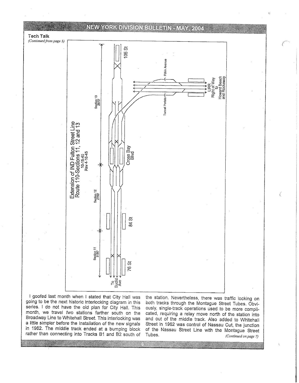
- The relay tracks east of Euclid Avenue on the IND Fulton Street Line were intended to continue towards Cambria Heights in Queens. As late as 1951, these relay tracks were still planned to go as far as 105th Street, with a connection to the IND Rockaway Line east of Cross Bay Boulevard.[3]
- A skylight is rumored to exist at the northeast corner of Pitkin Avenue and 80th Street, supposedly for the cancelled IND Fulton Street Line extension.
- A proposed subway station located at Jamaica Avenue below 212th Street in Queens Village probably also has skylights on the sidewalk along 212th Street and Jamaica Avenue.
- There is allegedly a subway tunnel along 73rd Avenue right to Alley Pond Park.
- Hillside Avenue widens out considerably at Springfield Boulevard in Queens Village, and gains a very wide median. As the 1929 plan has Springfield Boulevard as the eastern terminus of the IND Queens Boulevard Line, the wide median may have been constructed in advance for the never-built subway station there.
Shells built
The South Fourth Street shell, if complete, was supposed to handle service as follows:
| |||||||||||||||||||||||||||||||||||||||
The Utica Avenue station shell, if complete, would be in the standard local-express-express-local platform configuration.
Details
The first plan was made on September 15, 1929 (before the IND even opened), and is detailed in the table below. Cost is only for construction, and doesn't include land acquisition or other items.
| Line | Streets | From | To | Tracks | Route miles | Track miles | Cost | Notes |
|---|---|---|---|---|---|---|---|---|
| Manhattan | ||||||||
| East Manhattan trunk line (Second Avenue Line) | Water Street – New Bowery – Chrystie Street | Pine Street | Houston Street | 2 from Pine Street to Chambers Street 4 to Houston Street |
1.34 | 4.68 | $11,300,000 | subway |
| Second Avenue | Houston Street | Harlem River | 4 to 61st Street 6 to 125th Street 4 to Harlem River |
6.55 | 32.84 | $87,600,000 | subway | |
| 61st Street Line | Sixth Avenue – 61st Street | 52nd Street | Second Avenue | 2 | 1.1 | 2.2 | $6,700,000 | subway |
| (Rockaway Line) | Worth Street – East Broadway – Grand Street | Church Street | East River | 2 | 1.95 | 3.9 | $13,300,000 | subway |
| (Utica Avenue Line) | Houston Street | Essex Street | East River | 2 | .93 | 1.86 | $7,900,000 | subway |
| Manhattan total | 11.87 | 45.48 | $126,800,000 | |||||
| Bronx | ||||||||
| Bronx trunk line | Alexander Avenue – Melrose Avenue – Boston Road | Harlem River | West Farms | 4 | 3.97 | 15.88 | $40,400,000 | subway, with a portal between Vyse Avenue and 177th Street, then elevated into the existing IRT White Plains Road Line near 180th Street |
| White Plains Road Line | Morris Park Avenue – Wilson Avenue | Garfield Street | Boston Road | 2 | 3.5 | 7.9 | $13,700,000 | branching off the existing elevated IRT White Plains Road Line, and then going into subway |
| IRT Lafayette Avenue Line | 163rd Street – Hunts Point – Lafayette Avenue – 177th Street | Washington Avenue at Brook Avenue | East Tremont Avenue | 2 | 5.02 | 10.04 | $12,900,000 | subway to near Edgewater Road and Seneca Avenue, then elevated |
| Concourse Line Extension | Burke Avenue – Boston Road | Webster Avenue | Baychester Avenue | 2 | 2.15 | 4.3 | $8,900,000 | extension of the Concourse Line |
| White Plains Road Line | 180th Street | 241st Street | 4.40 | 13.2 | $2,100,000 | owned by IRT, to be taken over ("recaptured") by IND | ||
| Bronx total | 19.04 | 51.32 | $77,000,000 | |||||
| Brooklyn | ||||||||
| Broadway Branch Line (Rockaway Line) | Broadway | East River | Havemeyer Street at South Fourth Street | 2 | 3.16 | 13.5 | $34,800,000 | subway |
| Utica Avenue Line (and Rockaway Line from Havemeyer Street to Stuyvesant Avenue) | Grand Street – South Fourth Street – Beaver Street | East River | Stuyvesant Avenue | 2 to Driggs Avenue 4 to Union Avenue 8 to Bushwick Avenue 4 to Stuyvesant Avenue |
subway | |||
| Stuyvesant Avenue – Utica Avenue | Broadway | Flatbush Avenue | 4 | 5.85 | 23.4 | $39,300,000 | subway to Avenue J, then elevated | |
| Avenue S | Utica Avenue | Nostrand Avenue | 2 | 1.1 | 2.2 | $2,000,000 | elevated | |
| Nostrand Avenue | Avenue S | Voorhies Avenue | 4 | 1.3 | 5.2 | $3,200,000 | elevated | |
| Rockaway Line | Myrtle Avenue | Bushwick Avenue | Palmetto Avenue | 4 | 1.34 | 5.36 | $14,300,000 | subway |
| Fulton Street Line | Liberty Avenue | Fulton Street and Eastern Parkway | Grant Avenue | 4 | 1.84 | 7.36 | $13,500,000 | subway extending the Fulton Street Line to a portal at Liberty Avenue and Crescent Street, then elevated to connect to the BMT Liberty Avenue Line (now part of the Fulton Street Line) at Grant Avenue |
| Nostrand Avenue Extension | Flatbush Avenue | Avenue S | 2 | 2.25 | 4.5 | $7,400,000 | Extension of Nostrand Avenue Line as subway to Kings Highway, then elevated | |
| Brooklyn total | 16.84 | 61.52 | $114,500,000 | |||||
| Queens | ||||||||
| Rockaway Line | Myrtle Avenue – Central Avenue | Palmetto Avenue | 78th Street | 4 | 2.1 | 8.4 | $17,300,000 | subway to Central Avenue near 73rd Place, then along the surface or elevated |
| 98th Street – 99th Street – Hawtree Street | 78th Street | Hammels Station | 4 to Howard Beach 2 to Hammels |
9.2 | 26.2 | $20,200,000 | along the surface or elevated | |
| Rockaway Beach Boulevard | Beach 116th Street | Mott Avenue | 2 | 5.0 | 10.0 | $7,400,000 | along the surface or elevated | |
| Newport Avenue Line (Rockaway Line Extension) |
Newport Avenue | Beach 116th Street | Beach 149th Street | 2 | 1.6 | 3.2 | $2,400,000 | along the surface or elevated |
| Winfield Spur | Garfield Avenue – 65th Place – Fresh Pond Road | Broadway and 78th Street | Central Avenue | 2 | 3.34 | 6.68 | $10,100,000 | subway to 45th Avenue, then elevated to Fresh Pond Road, then subway |
| Brinckerhoff - Hollis Avenue Line (Fulton Street Line Extension) |
Liberty Avenue – 105th Avenue – Brinckerhoff Avenue – Hollis Avenue | Lefferts Boulevard | Springfield Boulevard | 2 | 6.2 | 13.3 | $10,700,000 | elevated extension of the BMT Liberty Avenue Line (now part of the Fulton Street Line) includes branch connection to BMT Jamaica Line (BMT) at 168th Street, via 180th Street and Jamaica Avenue |
| Van Wyck Boulevard Line | 137th Street – Van Wyck Boulevard | 87th Avenue | Rockaway Boulevard | 2 | 2.3 | 4.6 | $6,600,000 | subway to about 116th Avenue, then elevated |
| 120th Avenue Line | 120th Avenue – Springfield Boulevard | Hawtree Street near North Conduit Boulevard | Foch Boulevard | 4 to Van Wyck Boulevard 2 to Foch Boulevard |
5.23 | 13.92 | $9,500,000 | elevated |
| Bayside Line | Roosevelt Avenue – First Street – Station Road – 38th Avenue | Main Street | 221st Street | 3 to 147th Street 2 to 221st Street |
3.6 | 7.78 | $9,600,000 | extends the BMT/IRT Flushing Line as a subway to 155th Street, then elevated |
| College Point and Whitestone Line | 149th Street – 11th Avenue | Roosevelt Avenue and 147th Street | 11th Avenue and 122nd Street | 2 | 3.4 | 6.8 | $6,000,000 | subway to 35th Avenue, then elevated |
| Long Island City-Horace Harding Boulevard Line | Ditmars Avenue – Astoria Boulevard – 112th Street – Nassau Boulevard (Long Island Expressway) | Second Avenue | Cross Island Boulevard | 2 to Astoria Boulevard 4 to Parsons Boulevard 2 to Cross Island Boulevard |
8.1 | 26.71 | $17,700,000 | extends the BMT/IRT Astoria Line as an elevated, except that part of it may be depressed near Nassau Boulevard (Long Island Expressway) |
| Liberty Avenue Line | Grant Avenue | Lefferts Boulevard | 3 | 2.3 | 6.9 | $1,600,000 | owned by BMT, to be taken over ("recaptured") by IND now part of the Fulton Street Line | |
| Queens total | 52.37 | 136.49 | $119,100,000 | |||||
| Grand Total | 100.12 | 294.81 | $438,400,000 | |||||
Planned services
- A – 207th Street – Eighth Avenue – Fulton – Lefferts Boulevard
- AA – 168th Street – Eighth Avenue – Worth Street – South Fourth Street – Myrtle Avenue – Far Rockaway (non-rush)
- BB – 168th Street – Sixth Avenue – Worth Street – South Fourth Street – Myrtle Avenue – Far Rockaway (rush hours)
- CC – Concourse – Eighth Avenue – Houston Street – South Fourth Street – Utica Avenue
- D – Concourse – Sixth Avenue – Houston Street – South Fourth Street – Utica Avenue
- E – Archer – Queens Boulevard – Eighth Avenue – Fulton – Rockaway Park
- EE – Long Island Expressway – Queens Boulevard – 60th Street – BMT Broadway Line (Long Island Expressway added from ERA)
- F – Queens Boulevard – Sixth Avenue – Houston Street – Culver
- GG – Forest Hills – Crosstown – Church Avenue
- HH – Euclid Avenue – Rockaway Park – Far Rockaway (nights)
- HH – Cross Bay Boulevard – Far Rockaway (days)
- J – Crosstown – Myrtle Avenue – Roosevelt
- K – Far Rockaway – Roosevelt
- Q – Dyre Avenue – Second Avenue – Manhattan Bridge – BMT Southern Division
- R – 110th Street – Second Avenue – BMT Broadway Line
- T – Queens Boulevard Line – 63rd Street – Second Avenue – South Fourth – Utica Avenue
- V – Archer – Queens Boulevard – Sixth Avenue – Houston – Culver
- W – Pelham – Second Avenue – Court Street – Fulton – 105th Street (Long Island Expressway added from ERA)
1929–1940 plans
Later plans included the following:
- (1931 plan) A line splitting from the Second Avenue Line north of Houston Street, running southeast, merging with the Houston Street Line, and crossing the East River from Stanton Street towards the huge line under South Fourth Street.
- (1931 plan) A line splitting from the Crosstown Line where it turns from Lafayette Avenue to Marcy Avenue, continuing under Lafayette Avenue and Stanhope Street to a junction with the line under Myrtle Avenue.
- (1939 plan) A line splitting from the South Brooklyn (Culver) Line at Fort Hamilton Parkway, and running under Fort Hamilton Parkway to end at 86th Street. A branch would split to run under Ovington Avenue and Senator Street, with a tunnel under the Narrows to Staten Island at the St. George Terminal. The line would split, with the north branch ending at Westervelt Avenue around Hamilton Avenue, and the south branch ending at Grant Street around St. Pauls Street. It was presumably designed this way to provide future service to both the Main Line and North Shore Staten Island Railway lines. The Staten Island Tunnel commenced construction in the 1920s, but was not completed.
- (1939 plan) An extension of the IRT Lenox Avenue Line to connect with the IRT Ninth Avenue Line.
- (1940 plan, revised 1945) The IND Fulton Street Line would connect to what is now the IND Rockaway Line. A branch of the IND Fulton Street Line would run to a stub-end terminal at 105th Street. The line, east of Euclid Avenue , would be 4 tracks until Cross Bay Boulevard, where the two branches would split.[3]
- (unknown date) A third 2-track tunnel under the East River, from the north side of the South Fourth Street/Union Avenue station (as built for six tracks) west to Delancey Street.
- (unknown date) A line splitting from the Stuyvesant Avenue line, going southeast under Broadway.
- (unknown date) A line under Flushing Avenue from the huge line under Beaver Street to Horace Harding Boulevard (Long Island Expressway).
An earlier plan in 1920 had an even more expansive plan, with several dozen subway lines going across all five boroughs.[5]
1941–1999 plans
1951
In 1951, a plan was put forth to the New York Board of Transportation.[6] Many things were planned:
- Second Avenue Subway between 149th Street, the Bronx, to Grand Street, Manhattan. This line would handle 68 trains per hour (tph) (34 tph on the express tracks and 34 tph on the local tracks).
- Connections to the IRT Pelham Line at Third Avenue – 138th Street and to the IRT White Plains Road Line at Third Avenue – 149th Street.
- A tunnel to the IND Sixth Avenue Line via 57th Street.
- A tunnel under the East River to Eastern Queens via a planned super-express bypass to the LIRR Rockaway Beach Branch.
- A connection from the IND Queens Boulevard Line to the Rockaway Beach Branch and IND Rockaway Line.
- Various Bronx IRT projects:
- Increase in capacity on the IRT Pelham Line.
- Connection of the IRT Dyre Avenue Line to the IRT White Plains Road Line.
- Increase in capacity on the IRT White Plains Road Line north of Gun Hill Road by 8 trains per hour. (At the time, the IRT Third Avenue Line still connected to the IRT White Plains Road Line at Gun Hill Road.)
- Increase in capacity on the IRT Jerome Avenue Line by 9 trains per hour.
- The Chrystie Street Connection:
- IND Sixth Avenue Line express tracks.
- DeKalb Avenue rebuilding, including closure of the Myrtle Avenue station. This would increase capacity by 18 tph.
- Increase in capacity on the BMT Fourth Avenue Line's local tracks by 4 tph.
- Increase in capacity on the BMT Sea Beach Line by 9 tph.
- Increase in capacity on the BMT West End Line by 5 tph.
- Connection of the IND Second Avenue and IND Sixth Avenue Lines to the BMT Jamaica Line and to the Manhattan Bridge.
- Increase in capacity on the BMT Brighton Line by 8 tph by adding a connection from the BMT Brighton Line to the IND Culver Line at Ditmas Avenue.
- 60th Street Tunnel Connection.
- Extension of the IRT Nostrand Avenue Line to Voorhies Avenue.
- Construction of the IRT Utica Avenue Line from Crown Heights – Utica Avenue to Kings Plaza.
1968
Similar plans were made by the NYCTA in 1968.[7][8] They included:
- The IND Second Avenue Line with connections to IRT Dyre Avenue Line and IRT Pelham Line
- A crosstown line under 34th Street
- IND/BMT 63rd Street Line
- A new line running along Park Avenue in the Bronx
- Super-express bypass of IND Queens Boulevard Line
- New line splitting from the IND Queens Boulevard Line under the Long Island Expressway to Kissena Boulevard in Phase I and to Springfield Boulevard in Phase II
- Archer Avenue Line to Springfield Boulevard
- IRT Nostrand Avenue Line extension to Avenue W in Sheepshead Bay
- A new line running under Utica Avenue to Avenue U
- Extension of the BMT Canarsie Line to Nostrand Avenue or JFK Airport
- Extension of the IRT New Lots Line to Flatlands Avenue
- Extension of the IND Concourse Line to White Plains Road
1998
In 1998, an extension of the BMT Astoria Line to LaGuardia Airport was planned, but the plan was canceled in 2003 following community opposition.[9]
21st-century expansion
Since the 2000s, the New York City Subway has undergone its biggest expansion program since the late 1960s. With at least four stations under construction and up to 15 more subway stations definitively planned, the expansion plan pales in comparison to the IND Second System plans and the 1968 expansion plan noted above.
7 Subway Extension
The 7 Subway Extension — Hudson Yards Rezoning and Development Program is the plan to extend the IRT Flushing Line of the New York City Subway, which carries the 7 local and <7> express services, further westward into the New York City borough of Manhattan.[10] The extension stretches a total of 1 mile (1.6 km) from its current terminus at Times Square to a new western terminus at 34th Street and 11th Avenue.[10] However, the tunnels are actually 1.5 miles (2.4 km) long.[11] A second station at 10th Avenue – 41st Street was dropped from the plans in October 2007, but could be restored if funding can be found.[12] The extension's opening had been delayed to June 2014, with the rest of the 34th Street station to open at the end of 2015.[13][14] Michael Horodniceanu, chief of MTA Construction Company, told The New York Times that complications in the installation of the inclined elevator would likely cause a further delay of about three months, bringing the opening date to very late summer or early fall of 2014.[15] Further complications in February 2014 brought the projected date of the opening to November 2014.[16]
Second Avenue Subway
The Second Avenue Subway (SAS) is a planned rapid transit subway line, part of the New York City Subway system. As of 2013[update], Phase I, consisting of two miles (3.2 km) of tunnel and three stations, is under construction underneath Second Avenue in the borough of Manhattan, and is slated for completion in December 2016.[17]
The most recent and financially secure construction plan was launched when a tunnelling contract was awarded to the consortium of Schiavone/Shea/Skanska (S3) by the Metropolitan Transportation Authority (MTA) on March 20, 2007.[18] This followed preliminary engineering and a final tunnel design completed by a joint venture between AECOM and Arup.[19][20] Parsons Brinckerhoff is the Construction Manager of the project. This contract, and the full funding grant agreement with the Federal Transit Administration, which was received in November 2007, is for Phase I of the project, a new line between the existing BMT 63rd Street Line and 96th Street and Second Avenue.[21] The total cost of the 8.5-mile (13.7 km) line is expected to top $17 billion.[22]
A ceremonial ground-breaking for the Second Avenue Subway was held on April 12, 2007; the contractor prepared the initial construction site at 96th Street on April 23, 2007. A tunnel boring machine (TBM) was originally expected to arrive six to eight months after construction began, but the utility relocation and excavation required to create its "launch box" delayed its deployment until May 2010.[21] By May 2010, the TBM launch box was complete, and on May 14, 2010, MTA's contractors completed the TBM installation and turned it on.[23][24][25] On March 28, 2011, S3, having completed the west tunnel to 65th Street, began drilling for the east tunnel. The TBM completed its run to the 63rd Street station's bellmouth on September 22, 2011.[26]
Triboro RX
A proposal for the LIRR Bay Ridge Branch would have the New York City Subway use the tracks to link Brooklyn, Queens, and the Bronx via the Hell Gate Bridge.[27] In 1996 the Regional Plan Association conducted a study to determine the feasibility of the rail link.[28] Based on Paris's RER commuter rail system, the Triboro RX proposal will create a loop around the city. It was first proposed by the Regional Plan Association in 1996, and has been denounced as disastrous by some.[29] The proposed line, discussion of which was revived in 2012, would connect to all non-shuttle subway services.[30] Obstacles for the proposal include the proposed Cross-Harbor Rail Tunnel, the lack of electrification on the line, and the single-tracking in some parts of the line. Additionally, there is debate on where the line's northern terminus would be: some project it to end at Hunts Point,[27] while others plan the line to end at Yankee Stadium.[30]
Other plans
Some plans call for the IND Rockaway Line to be extended along the right-of-way of the LIRR Rockaway Beach Branch, as the success of a new racino at Aqueduct Racetrack led to a proposal from Governor Andrew Cuomo to build a massive convention center in the vicinity. Talks of reactivating the line were publicly endorsed in February 2012 by Assemblymen Phillip Goldfeder and Michael G. Miller. Goldfeder commented “The commute for people here is only going to go from bad to worse. You can’t talk about a convention center without talking about transportation.” Goldfeder and Miller said they are not opposed to turning sections of the line into a park, but said people who live in Rockaway, Ozone Park and other areas have no quick or easy way to get into Manhattan. The Genting Group, which operates the racino and has been asked to construct the convention center, are evaluating several plans to increase transportation access. Genting is committed to paying for part of the transportation improvements. Queensway advocates are against resumption of rail service, stating that current bus service fills current transportation needs in the area.[31] Congressmen Hakeem Jeffries and Gregory Meeks added their support for the project in March 2013. Both representatives will push to allocate federal transportation subsidies to study a plan for restored passenger service.[32]
The BMT Astoria Line extension to LaGuardia Airport is again being considered as part of LaGuardia's long-range expansion/renovation plan. Currently, no New York City Subway routes service the airport directly, but provisions for a subway connection are part of a 2014 long range rebuilding plan by the MTA.[33]
Legacy
References
- ^ "A New Subway Line for New York City, The Triborough System: Its History (1910)". www.nycsubway.org. Retrieved 2014-03-25.
- ^ "The Dual System of Rapid Transit (1912)". www.nycsubway.org. Retrieved 2014-03-25.
- ^ a b Track diagram of the revised plan
- ^ http://www.thejoekorner.com/scripted-s-4-display.shtm?http://www.thejoekorner.com/indsecondsystem/s4th5.gif
- ^ "Transit Maps". Transitmaps.tumblr.com. 2013-04-05. Retrieved 2014-03-25.
- ^ "Board of Transportation - 1951". Thejoekorner.com. Retrieved 2014-03-25.
- ^ "1968 NYCTA Expansion Plans (Picture)". Second Avenue Sagas. Retrieved December 2013.
{{cite web}}: Check date values in:|accessdate=(help) - ^ Program for Action maps from thejoekorner.com
- ^ "Flashback To 1999 | www.qgazette.com | Queens Gazette". www.qgazette.com. 2007-06-27. Retrieved 2014-03-25.
- ^ a b "Work to Begin Under Last Major Contract Needed to Extend the 7". MTA.info. September 14, 2011. Archived from the original on August 17, 2012. Retrieved September 16, 2011.
- ^ "7 Line Extension". MTA.info. Retrieved November 10, 2013.
- ^ "Transit Board Approves Funding For 7 Line Extension". NY1. October 25, 2007. Retrieved February 28, 2010.
- ^ "MTA's 7 Line Extension Project Pushed Back Six Months". NY1. June 5, 2012. Archived from the original on July 11, 2012. Retrieved June 5, 2012.
- ^ Cuozzo, Steve (June 5, 2012). "No. 7 train 6 mos. late". New York Post. Retrieved June 5, 2012.
- ^ "More Delays and Rising Cost for Project Connecting L.I.R.R. to Grand Central Terminal". New York Times. January 27, 2014.
- ^ Kabak, Benjamin (February 27, 2014). "7 line extension opening now projected for November". Second Avenue Sagas. Retrieved March 5, 2014.
- ^ MTA releases Second Avenue subway images, says project on track NY Daily News, November 5, 2013
- ^ MTA Press Release March 20, 2007
- ^ "Arup to design new Second Avenue Subway, New York". Arup. November 20, 2001. Archived from the original on February 5, 2009. Retrieved June 9, 2013.
- ^ "Second Avenue Subway – Transport Consulting". Arup. Archived from the original on February 2, 2009. Retrieved June 9, 2013.
- ^ a b "Second Avenue Subway – A Status Report" (PDF). Retrieved August 2, 2009.
- ^ Sargent, Greg (March 29, 2004). "The Line That Time Forgot – Second Avenue Subway". Nymag.com. Retrieved August 2, 2009.
{{cite journal}}: Cite journal requires|journal=(help) - ^ " "Blasting on Second Avenue". thelaunchbox.blogspot.com. March 22, 2010.
- ^ Siff, Andrew (May 14, 2010). "2nd Ave. Subway Tunnel Dig Begins". WNBC. Retrieved May 14, 2010.
- ^ "Tunneling Begins Under Second Avenue". MTA. May 14, 2010. Archived from the original on August 17, 2012. Retrieved May 17, 2010.
- ^ Various (2011-09-23). "Second Avenue Subway has a breakthrough moment; several billion more are all the M.T.A. wants". Capital New York. Retrieved 2014-03-31.
- ^ a b "How About A Subway Linking Brooklyn, Queens & The Bronx WITHOUT Manhattan?". Gothamist. August 22, 2013. Retrieved August 22, 2013.
- ^ Third Regional Plan Summary
- ^ "The Triboro RX: An RX for disaster". ltvsquad.com. Retrieved 2014-03-25.
- ^ a b Rubinstein, Dana (2012-04-25). "The surprising return of the three-borough 'X line' subway". Capital New York. Retrieved 2014-03-25.
- ^ Colangelo, Lisa L. (February 13, 2012). "Lawmakers: southern Queens commuters need a new railway more than the Queensway". Daily News. New York. Retrieved 2012-02-14.
- ^ Rafter, Domenick (March 21, 2013). "Rockaway Beach rail plan to be backed by Reps. Jeffries, Meeks". Queens Chronicle. Retrieved 2013-03-21.
- ^ http://ny.curbed.com/archives/2014/03/19/a_revamped_la_guardia_airport_could_look_like_this_in_2021.php
Further reading
- 100 Miles of Subway in New City Project; 52 of them in Queens, New York Times September 16, 1929 page 1
External links
- NYCsubway.org – IND Second System
- NYCsubway.org – Roosevelt Avenue Terminal Station
- Abandoned Stations – IND Second System unfinished stations
- Abandoned Stations – Roosevelt Ave upper level
- Broadway-South 4 Street Station (junction with the Crosstown Line) photos
- Roosevelt Avenue-Winfield Spur Station (split from the Queens Boulevard Line) photos
- JoeKorNer – IND Second System (including a plan for a line to Staten Island)
- JoeKorNer – Roosevelt Rockaway Line (photos of the unused station)
| Current services |
| ||||||||||||
|---|---|---|---|---|---|---|---|---|---|---|---|---|---|
| Defunct services |
| ||||||||||||
| Stations (List) |
| ||||||||||||
| Divisions | |||||||||||||
| Other lists | |||||||||||||
| History |
| ||||||||||||
| Infrastructure | |||||||||||||
| Arts and culture | |||||||||||||
| Miscellaneous | |||||||||||||
| Other rapid transit in NYC |
| ||||||||||||