Saint-Jean-Baptiste | |
|---|---|
 Principal Street | |
 Location within La Vallée-du-Richelieu RCM | |
 Saint-Jean-Baptiste Location in southern Quebec | |
| Coordinates: 45°31′N 73°07′W / 45.517°N 73.117°W[1] | |
| Country | |
| Province | |
| Region | Montérégie |
| RCM | La Vallée-du-Richelieu |
| Constituted | July 1, 1855 |
| Government | |
| • Mayor | Marilyn Nadeau |
| • Federal riding | Beloeil—Chambly |
| • Prov. riding | Borduas |
| Area | |
| • Total | 73.00 km2 (28.19 sq mi) |
| • Land | 72.36 km2 (27.94 sq mi) |
| Population (2021)[4] | |
| • Total | 3,179 |
| • Density | 43.9/km2 (114/sq mi) |
| • Pop 2016-2021 | |
| • Dwellings | 1,386 |
| Time zone | UTC−5 (EST) |
| • Summer (DST) | UTC−4 (EDT) |
| Postal code(s) | |
| Area code(s) | 450 and 579 |
| Highways | |
| Website | www |
Saint-Jean-Baptiste is a municipality in the Montérégie region of Quebec, a Canadian province. The population as of the Canada 2021 Census was 3,179. It is located within La Vallée-du-Richelieu Regional County Municipality in a valley between Mont Saint-Hilaire and Mont Rougemont.
On November 4, 1998 it moved from Rouville Regional County Municipality to La Vallée-du-Richelieu Regional County Municipality.
Demographics[edit]
Population[edit]Population trend:[5]
|
Language[edit]Mother tongue language (2021)[6]
|
Education[edit]

The South Shore Protestant Regional School Board previously served the municipality.[7]
Photo gallery[edit]
-
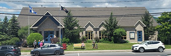 Community center located opposite the church, on Principale Street
 -
 church of Saint-Jean-Baptiste and the mass grave
 -
 View of Mont Saint-Hilaire and crop fields from Route 229 (north of the village of Saint-Jean-Baptiste)
 -
 View of the front facade of the town hall, located next to the church
 -
 Information panel installed in front of the town hall
 -
 View of rue Principale (near the corner of chemin de Rouville), on the south side of the village
 -
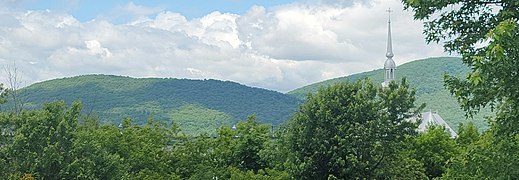 view of Mont Saint-Hilaire (in the background) and the steeple of the church of the village of Saint-Jean-Baptiste


See also[edit]
References[edit]
- ^ "Banque de noms de lieux du Québec: Reference number 377887". toponymie.gouv.qc.ca (in French). Commission de toponymie du Québec.
- ^ a b Ministère des Affaires municipales, des Régions et de l'Occupation du territoire: Saint-Jean Baptiste
- ^ Parliament of Canada Federal Riding History: CHAMBLY--BORDUAS (Quebec)
- ^ a b 2021 Statistics Canada Census Profile: Saint-Jean-Baptiste, Quebec
- ^ Statistics Canada: 1996, 2001, 2006, 2011, 2016, 2021 census
- ^ 2021 Statistics Canada Community Profile: Saint-Jean-Baptiste, Quebec
- ^ King, M.J. (Chairperson of the board). "South Shore Protestant Regional School Board" (St. Johns, PQ). The News and Eastern Townships Advocate. Volume 119, No. 5. Thursday December 16, 1965. p. 2. Retrieved from Google News on November 23, 2014.
External links[edit]
Adjacent Municipal Subdivisions | ||||||||||||||||
|---|---|---|---|---|---|---|---|---|---|---|---|---|---|---|---|---|
| ||||||||||||||||
| Cities | |
|---|---|
| Municipalities | |
| |
| International | |
|---|---|
| National | |
| Geographic | |