Payyanur taluk
Payyannur | |
|---|---|
Taluk | |
 Taluks of Kannur | |
| Coordinates: 12°09′13″N 75°18′38″E / 12.1535°N 75.3106°E | |
| Country | |
| State | Kerala |
| District | Kannur |
| Established | March 2018 |
| Government | |
| • Type | Taluk |
| • Tehsildar | K. Balagopalan |
| Area | |
| • Taluk | 513.52 km2 (198.27 sq mi) |
| • Urban | 155.35 km2 (59.98 sq mi) |
| • Rural | 358.17 km2 (138.29 sq mi) |
| Population (2011) | |
| • Taluk | 351,526 |
| • Density | 680/km2 (1,800/sq mi) |
| • Urban | 199,501 |
| • Urban density | 1,300/km2 (3,300/sq mi) |
| • Rural | 152,025 |
| • Rural density | 420/km2 (1,100/sq mi) |
| Languages | |
| • Official | Malayalam, English |
| Time zone | UTC+5:30 (IST) |
| PIN | 670xxx |
| Telephone code | 04985, 0497 |
| Vehicle registration | KL 86 |
| Lok Sabha constituency | Kasaragod |
| Vidhan Sabha constituency | Payyanur, Kalliasseri |
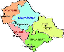
Payyanur taluk comes under Taliparamba revenue division in Kannur district of Kerala, India. Payyanur is one of the 5 taluks in Kannur district established in March 2018 carved out from Taliparamba and Kannur taluks. Payyanur taluk comprises 22 villages including 16 delinked from Taliparamba taluk and 6 from Kannur taluk.[1] It borders Kasaragod district in the north, Taliparamba and Kannur taluk in the south and Karnataka state in the east.[2] Most of the government offices are in Payyanur Mini Civil Station. Payyanur taluk consists of Payyanur Municipality and 11 Panchayats.[3][4]
Constituent Villages[edit]
Payyanur taluk has 22 villages: Alapadamba, Cheruthazham, Eramam, Ezhome, Kadannappalli, Kankole, Karivellur, Korom, Kuttur, Kunhimangalam, Madayi, Panapuzha, Payyanur, Peralam, Peringome, Perinthatta, Pulingome, Ramanthali, Thirumeni, Vayakkara, Vellora and Vellur.[5]
References[edit]
- ^ "Payyannur taluk to be a reality this week! | Kozhikode News - Times of India". The Times of India.
- ^ Unnithan, Rajmohan (24 February 2020). "Payyanur's Gandhi connection" – via www.thehindu.com.
- ^ "Taluks(5) | Kannur District , Government of kerala | India".
- ^ "Rebuild Kerala-Payyannur Taluk-Flood 2018 | Kannur District , Government of kerala | India".
- ^ "VILLAGE OFFICES IN PAYYANNUR TALUK" (PDF). cdn.s3waas.gov.in. Retrieved 20 September 2020.

