| Meayll Hill | |
|---|---|
| Cronk Meayll | |
 Meayll Circle on top of Meayll Hill, looking north towards Port Erin | |
| Highest point | |
| Elevation | 169 m (554 ft) |
| Prominence | c. 154 m |
| Listing | Marilyn |
| Coordinates | 54°04′27″N 4°46′07″W / 54.0740534°N 4.76866°W |
| Geography | |
| Location | Rushen, Isle of Man |
| OS grid | SC189676 |
| Topo map | OS Landranger 95 IOM Outdoor Leisure Map (S) |
 | |
Meayll Hill (Manx: Cronk Meayll; also called The Mull) is a small hill in the exclave of Rushen parish at the southern end of the Isle of Man, just outside the village of Cregneash. It is the site of a chambered cairn called Meayll Circle or Mull Circle. Near the summit of the hill also lie the remains of a World War II Chain Home Low RDF station.
Meayll Hill Stone Circle is a unique archaeological monument. It consists of twelve burial chambers placed in a ring, with six entrance passages each leading into a pair of chambers. Sherds of ornate pottery, charred bones, flint tools and white quartz pebbles have been found in the burial chambers. It was built around 3500 BC; it is a site of legends, with diverse stories about haunting.
The word Meayll means "bald" in Manx Gaelic.
Meayll Circle[edit]
- The Stone Circle and artifacts
-
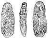 Three views of an adze, from Meayll Hill
 -
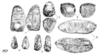 Worked flints found on Meayll Hill
 -
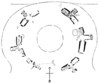 Plan of the Meayll Stone Circle
 -
 Meayll Stone Circle from the east
 -
 Meayll Stone Circle, excavated cist
 -
 Meayll Stone Circle, excavated cist (another view)


References[edit]
Bibliography
- Kermode, Philip Moore Callow (June 1894), Allen, J. Romilly (ed.), "The illustrated archaeologist: a quarterly journal, devoted to the study of the antiquities of Great Britain; the development of the arts and industries of man in past ages; and the survivals of ancient usages and appliances in the present", The Illustrated Archaeologist, I, London: Charles J. Clark (published 1894): 1–8
- Kermode, Philip Moore Callow; Herdman, W. A. (1904), Illustrated Notes on Manks Antiquities, Liverpool
{{citation}}: CS1 maint: location missing publisher (link)
Citations
External links[edit]