
Size of this preview: 758 × 600 pixels. Other resolutions: 303 × 240 pixels | 607 × 480 pixels | 970 × 768 pixels | 1,280 × 1,013 pixels | 1,324 × 1,048 pixels.
Original file (1,324 × 1,048 pixels, file size: 1.53 MB, MIME type: image/png)
Summary
| Description |
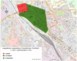
Deutsch: Lageskizze des römischen Kastells Luguvalium und der Zivilstadt Luguvalium Carvetiorum vom 1. bis 4. Jahrhundert n.Chr. (Carlisle, England). |
| Date | |
| Source | © OpenStreetMap-Mitwirkende, bearbeitet durch Veleius |
| Author | Veleius |
Vorlage: Higham/Jones: The Carvetii (Fig.28 S.58).
Licensing
I, the copyright holder of this work, hereby publish it under the following license:
This file is licensed under the Creative Commons Attribution-Share Alike 3.0 Unported license.
- You are free:
- to share – to copy, distribute and transmit the work
- to remix – to adapt the work
- Under the following conditions:
- attribution – You must give appropriate credit, provide a link to the license, and indicate if changes were made. You may do so in any reasonable manner, but not in any way that suggests the licensor endorses you or your use.
- share alike – If you remix, transform, or build upon the material, you must distribute your contributions under the same or compatible license as the original.
File history
Click on a date/time to view the file as it appeared at that time.
| Date/Time | Thumbnail | Dimensions | User | Comment | |
|---|---|---|---|---|---|
| current | 22:24, 31 January 2020 | | 1,324 × 1,048 (1.53 MB) | Veleius | {{Information |description ={{de|1=Lageskizze des römischen Kastells Luguvalium und der Zivilstadt Luguvalium Carvetiorum vom 1. bis 4. Jahrhundert n.Chr. (Carlisle, England).}} |date =2020-01-31 |source =© OpenStreetMap-Mitwirkende, bearbeitet durch Veleius |author =User:Veleius }} Vorlage: Higham/Jones: The Carvetii (Fig.28 S.58). Category:Carlisle |
File usage
The following pages on the English Wikipedia use this file (pages on other projects are not listed):
Global file usage
The following other wikis use this file:
- Usage on de.wikipedia.org
.png)