
Size of this preview: 800 × 521 pixels. Other resolutions: 320 × 209 pixels | 640 × 417 pixels | 1,024 × 667 pixels | 1,280 × 834 pixels | 3,008 × 1,960 pixels.
Original file (3,008 × 1,960 pixels, file size: 1.03 MB, MIME type: image/jpeg)
Summary
| Camera location | | View this and other nearby images on: OpenStreetMap |
|---|
.JPG¶ms=040.000000_N_0023.000000_E_globe:Earth_type:camera__&language=en)
| Description |
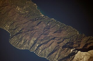
Español: Península del Monte Athos.
English: Athos Peninsula. |
| Date | |
| Source | http://eol.jsc.nasa.gov/scripts/sseop/photo.pl?mission=ISS014&roll=E&frame=12302&QueryResultsFile=133690347850762.tsv |
| Author | NASA |
Licensing
| This file is in the public domain in the United States because it was solely created by NASA. NASA copyright policy states that "NASA material is not protected by copyright unless noted". (See Template:PD-USGov, NASA copyright policy page or JPL Image Use Policy.) | ||
 |
Warnings:
|
File history
Click on a date/time to view the file as it appeared at that time.
| Date/Time | Thumbnail | Dimensions | User | Comment | |
|---|---|---|---|---|---|
| current | 14:57, 25 August 2014 | | 3,008 × 1,960 (1.03 MB) | Ras67 | high res |
| 20:24, 25 May 2012 |  | 640 × 414 (65 KB) | Dorieo |
File usage
The following pages on the English Wikipedia use this file (pages on other projects are not listed):
.JPG)