Prague 19
Praha 19 | |
|---|---|
Municipal District of Prague Administrative District of Prague | |
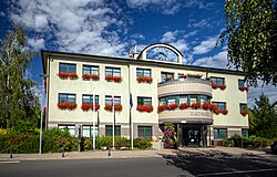
 Prague 19 town hall | |
 Location of Prague 19 in Prague | |
| Coordinates: 50°8′0″N 14°32′58″E / 50.13333°N 14.54944°E | |
| Country | Czech Republic |
| Region | Prague |
| Government | |
| • Mayor | Pavel Žďárský |
| Area | |
| • Total | 5.99 km2 (2.31 sq mi) |
| Population (2021) | |
| • Total | 7,216 |
| • Density | 1,200/km2 (3,100/sq mi) |
| Time zone | UTC+1 (CET) |
| • Summer (DST) | UTC+2 (CEST) |
| Postal code | 197 00 |
| Website | http://www.praha19.cz |
Prague 19, also known as Kbely (German: Gbel), is a municipal district (městská část) in Prague. It is located in the north-eastern part of the city. It is formed by one cadastre, Kbely. As of 2008[update], there were 6,149 inhabitants living in Prague 19.
The administrative district (správní obvod) of the same name consists of municipal districts Prague 19, Satalice and Vinoř.

Climate[edit]
| Climate data for Kbely (1991−2020) | |||||||||||||
|---|---|---|---|---|---|---|---|---|---|---|---|---|---|
| Month | Jan | Feb | Mar | Apr | May | Jun | Jul | Aug | Sep | Oct | Nov | Dec | Year |
| Record high °C (°F) | 17.0 (62.6) |
18.5 (65.3) |
22.4 (72.3) |
30.2 (86.4) |
31.2 (88.2) |
37.0 (98.6) |
36.7 (98.1) |
38.0 (100.4) |
32.9 (91.2) |
26.1 (79.0) |
18.9 (66.0) |
14.1 (57.4) |
38.0 (100.4) |
| Mean daily maximum °C (°F) | 2.3 (36.1) |
4.1 (39.4) |
8.7 (47.7) |
14.9 (58.8) |
19.4 (66.9) |
22.5 (72.5) |
24.8 (76.6) |
24.8 (76.6) |
19.4 (66.9) |
13.2 (55.8) |
7.0 (44.6) |
3.2 (37.8) |
13.7 (56.6) |
| Daily mean °C (°F) | −0.1 (31.8) |
1.0 (33.8) |
4.6 (40.3) |
9.9 (49.8) |
14.3 (57.7) |
17.8 (64.0) |
19.8 (67.6) |
19.4 (66.9) |
14.6 (58.3) |
9.3 (48.7) |
4.4 (39.9) |
0.9 (33.6) |
9.7 (49.4) |
| Mean daily minimum °C (°F) | −3.0 (26.6) |
−2.5 (27.5) |
0.4 (32.7) |
4.3 (39.7) |
8.8 (47.8) |
12.4 (54.3) |
14.3 (57.7) |
13.9 (57.0) |
9.7 (49.5) |
5.4 (41.7) |
1.5 (34.7) |
−1.8 (28.8) |
5.3 (41.5) |
| Record low °C (°F) | −23.1 (−9.6) |
−20.9 (−5.6) |
−15.7 (3.7) |
−7.2 (19.0) |
−2.1 (28.2) |
2.6 (36.7) |
7.0 (44.6) |
5.1 (41.2) |
0.5 (32.9) |
−7.5 (18.5) |
−11.7 (10.9) |
−22.8 (−9.0) |
−23.1 (−9.6) |
| Average precipitation mm (inches) | 22.3 (0.88) |
21.3 (0.84) |
31.3 (1.23) |
26.7 (1.05) |
59.5 (2.34) |
70.5 (2.78) |
70.1 (2.76) |
64.9 (2.56) |
45.1 (1.78) |
34.2 (1.35) |
30.8 (1.21) |
29.0 (1.14) |
505.7 (19.92) |
| Average precipitation days (≥ 1.0 mm) | 6.8 | 5.8 | 7.8 | 6.5 | 9.2 | 9.5 | 9.2 | 8.8 | 6.9 | 7.3 | 7.2 | 6.7 | 91.7 |
| Mean monthly sunshine hours | 47.3 | 77.9 | 120.9 | 187.8 | 224 | 232.3 | 242.4 | 231 | 161.7 | 104.1 | 49.6 | 41.8 | 1,720.8 |
| Source: NOAA[1] | |||||||||||||
Demographics[edit]
| Year | Pop. | ±% |
|---|---|---|
| 1869 | 677 | — |
| 1880 | 898 | +32.6% |
| 1890 | 1,054 | +17.4% |
| 1900 | 1,322 | +25.4% |
| 1910 | 1,518 | +14.8% |
| 1921 | 1,765 | +16.3% |
| 1930 | 5,546 | +214.2% |
| 1950 | 5,884 | +6.1% |
| 1961 | 6,929 | +17.8% |
| 1970 | 6,698 | −3.3% |
| 1980 | 5,688 | −15.1% |
| 1991 | 4,669 | −17.9% |
| 2001 | 4,592 | −1.6% |
| 2011 | 6,768 | +47.4% |
| 2021 | 7,216 | +6.6% |
| Source: Censuses[2][3] | ||
See also[edit]
References[edit]
- ^ "Climate Normals for 1991-2020: Praha (Kbely)" (CSV). National Oceanic and Atmospheric Administration. Retrieved 2 April 2024.
WMO number: 11567
- ^ "Historický lexikon obcí České republiky 1869–2011 – Praha" (in Czech). Czech Statistical Office. 2015-12-21. pp. 7–8.
- ^ "Population Census 2021: Population by sex". Public Database. Czech Statistical Office. 2021-03-27.
External links[edit]


Well, that’s interesting to know that Psilotum nudum are known as whisk ferns. Psilotum nudum is the commoner species of the two. While the P. flaccidum is a rare species and is found in the tropical islands. Both the species are usually epiphytic in habit and grow upon tree ferns. These species may also be terrestrial and grow in humus or in the crevices of the rocks.
View the detailed Guide of Psilotum nudum: Detailed Study Of Psilotum Nudum (Whisk Fern), Classification, Anatomy, Reproduction