
This is the list of cities, towns, and villages in the country of Cameroon:


| City | Region | Population (2021), References |
|---|---|---|
| Abong-Mbang | East | 14,661[1] |
| Ako | Northwest | [2] |
| Akonolinga | Centre | 17,181[1] |
| Ambam | South | 8,476[1] |
| Bafang | West | 80,688[1] |
| Bafia | Centre | 69,270[1] |
| Bafoussam (Regional capital) | West | 290,768[1] |
| Bafut (Kingdom) | Northwest | 120,000[3] |
| Bali | Northwest | 72,606[1] |
| Bambili (French) | Northwest | 5,641[4] |
| Bamenda (Regional capital) | Northwest | 393,835[1] |
| Batibo | Northwest | 9,163[1] |
| Bandjoun | West | 6,872[1] |
| Bangem | Southwest | |
| Banyo | Adamawa | 40,798[1] |
| Batouri | East | 43,821[1] |
| Bélabo | East | 22,553[1] |
| Bertoua (Regional capital) | East | 218,111[1] |
| Buea (Regional capital) | Southwest | 47,300[1] |
| Campo | South | |
| Dimako | East | 8,476[1] |
| Dizangue | Littoral | 19,243[1] |
| Djoum | South | |
| Douala (Regional capital, port, railhead) | Littoral | 1,338,082[1] |
| Dschang | West | 96,112[1] |
| Ebolowa (Regional Capital) | South | 87,875[1] |
| Edéa | Littoral | 203,149[1] |
| Eyumojock | Southwest | |
| Fontem | Southwest | 42,689[1] |
| Foumban | West | 92,673[1] |
| Foumbot | West | 84,065[1] |
| Fundong | Northwest | 43,509[1] |
| Garoua (Regional capital) | North | 436,899[1] |
| Garoua-Boulaï | East | 46,615[1] |
| Guider | North | 84,647[1] |
| Idenau | Southwest | |
| Kaélé | Far North | 25,199[1] |
| Kousséri | Far North | 435,547[1] |
| Kribi | South | 55,224[1] |
| Kumba | Southwest | 144,413[1] |
| Kumbo | Northwest | 53,970[1] |
| Limbé | Southwest | 72,106[1] |
| Lomié | East | |
| Loum | Littoral | 177,429[1] |
| Makénéné | Centre | |
| Mamfe | Southwest | 19,472[1] |
| Manjo | Littoral | 37,661[1] |
| Maroua (Regional capital) | Far North | 319,941[1] |
| Martap | Adamawa | |
| Mbalmayo | Centre | 80,206[1] |
| Mbandjock (Mbandjok) | Centre | 26,947[1] |
| Mbanga | Southwest | 42,590[1] |
| Mbê | Multiple | [2] |
| Mbengwi | Northwest | 9,734[1] |
| Mbouda | West | 111,320[1] |
| Meiganga | Adamawa | 80,100[1] |
| Melong | Littoral | 37,086[1] |
| Menji | Southwest | |
| Muyuka | Southwest | 31,384[1] |
| Nkoteng | Centre | 50,334[1] |
| Mokolo | Far North | 275,239[1] |
| Monatélé | Centre | |
| Mora | Far North | 55,216[1] |
| Mouloudou | East | |
| Mutengene | Southwest | 47,478[1] |
| Nanga Eboko | Centre | 29,909[1] |
| Ndu | Northwest | |
| Ndop | Northwest | 25,740[1] |
| Ngaoundéré (Regional capital, railhead) | Adamawa | 231,357[1] |
| Nkambe | Northwest | 17,191[1] |
| Nkongsamba | Littoral | 117,063[1] |
| Nkwen | Northwest and West | |
| Obala | Centre | 30,012[1] |
| Penja | Littoral | 28,406[1] |
| Sa'a | Centre | 5,727[1] |
| Sangmélima | South | 54,251[1] |
| Santa | Northwest | |
| Tibati | Adamawa | 35,589[1] |
| Tiko | Southwest | 55,914[1] |
| Wum | Northwest | 68,836[1] |
| Yaoundé (capital) | Centre | 1,299,369[1] |
| Yagoua | Far North | 80,235[1] |
| Yokadouma | East | 13,287[1] |
| Ndop | North West |
Villages[edit]
- Bodo
- Goura, Centre Region
- Goura, Far North Region
- Ngoila
- Nkuv
- Mmuock Leteh
- Babungo
- Baba
- Babessi
- Bangolan
- Bamunka
-
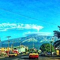 Buea
Buea -
 Atlantic Ocean, Limbe
 -
 Drill, Limbe Wildlife Centre
 -
 Dschang
 -
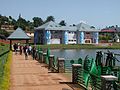
 Kribi Beach
 -
 View of a beautiful crick in Idenau


See also[edit]
References[edit]
- ^ a b c d e f g h i j k l m n o p q r s t u v w x y z aa ab ac ad ae af ag ah ai aj ak al am an ao ap aq ar as at au av aw ax ay az ba bb bc bd be bf bg bh bi bj bk bl bm bn "Population of cities in Cameroon". World Population Review. Retrieved May 23, 2021.
- ^ a b c "Cameroon". GEO Names. Retrieved May 23, 2021.
- ^ "Baut Kingdom". Bafutmanjongcalgary. Retrieved May 23, 2021.
- ^ Répertoire actualisé des villages du Cameroun. Troisième recensement général de la population et de l'habitat du Cameroun, Bureau central des recensements et des études de population, vol. 4, tome 7, 2005, p. 317 [1]
External links[edit]
![]() Media related to Cities in Cameroon at Wikimedia Commons
Media related to Cities in Cameroon at Wikimedia Commons
Well, that’s interesting to know that Psilotum nudum are known as whisk ferns. Psilotum nudum is the commoner species of the two. While the P. flaccidum is a rare species and is found in the tropical islands. Both the species are usually epiphytic in habit and grow upon tree ferns. These species may also be terrestrial and grow in humus or in the crevices of the rocks.
View the detailed Guide of Psilotum nudum: Detailed Study Of Psilotum Nudum (Whisk Fern), Classification, Anatomy, Reproduction