La Bridoire | |
|---|---|
 A general view of La Bridoire | |
 Coat of arms | |
Location of La Bridoire  | |
 La Bridoire  La Bridoire | |
| Coordinates: 45°31′37″N 5°44′36″E / 45.5269°N 5.7433°E | |
| Country | France |
| Region | Auvergne-Rhône-Alpes |
| Department | Savoie |
| Arrondissement | Chambéry |
| Canton | Le Pont-de-Beauvoisin |
| Intercommunality | Val Guiers |
| Government | |
| • Mayor (2020–2026) | Yves Berthier[1] |
| Area 1 | 6.18 km2 (2.39 sq mi) |
| Population (2021)[2] | 1,228 |
| • Density | 200/km2 (510/sq mi) |
| Time zone | UTC+01:00 (CET) |
| • Summer (DST) | UTC+02:00 (CEST) |
| INSEE/Postal code | 73058 /73520 |
| Elevation | 250–527 m (820–1,729 ft) |
| 1 French Land Register data, which excludes lakes, ponds, glaciers > 1 km2 (0.386 sq mi or 247 acres) and river estuaries. | |
La Bridoire (French pronunciation: [la bʁidwaʁ]; Arpitan: La Barduire) is a commune in the Savoie department in the Auvergne-Rhône-Alpes region in south-eastern France.
Geography
[edit]Climate
[edit]According to a 2010 study by the French National Centre for Scientific Research, the commune is situated in a "mountain margins climate".[3] In 2020, Météo-France published its own typology of French climates in which it categorized the commune's climate as a mountain climate or mountain margins climate within the Northern Alps climate region.[4]
From 1971 to 2000, the average annual temperature was 10.9 °C (51.6 °F), with an annual range of 19.2 °C (66.6 °F). The average annual rainfall was 1,263 millimetres (49.7 in), with 9.9 days of rainfall in January and 7.8 days of rainfall in July.[3]
-
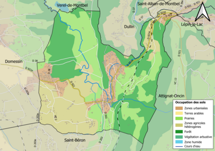 Map of the commune's infrastructure and land use in 2018
 -
 Satellite image of the commune


See also
[edit]References
[edit]- ^ "Répertoire national des élus: les maires". data.gouv.fr, Plateforme ouverte des données publiques françaises (in French). 9 August 2021.
- ^ "Populations légales 2021" (in French). The National Institute of Statistics and Economic Studies. 28 December 2023.
- ^ a b Daniel Joly, Thierry Brossard, Hervé Cardot, Jean Cavailhes, Mohamed Hilal et Pierre Wavresky (18 June 2010), "Les types de climats en France, une construction spatiale", Cybergéo, revue européenne de géographie - European Journal of Geography (in French), no. 501, doi:10.4000/cybergeo.23155, retrieved 29 July 2024
{{citation}}: CS1 maint: multiple names: authors list (link) - ^ "Zonages climatiques en France métropolitaine". pluiesextremes.meteo.fr (in French). Retrieved 29 July 2024.
| Authority control databases: National |
|---|
Well, that’s interesting to know that Psilotum nudum are known as whisk ferns. Psilotum nudum is the commoner species of the two. While the P. flaccidum is a rare species and is found in the tropical islands. Both the species are usually epiphytic in habit and grow upon tree ferns. These species may also be terrestrial and grow in humus or in the crevices of the rocks.
View the detailed Guide of Psilotum nudum: Detailed Study Of Psilotum Nudum (Whisk Fern), Classification, Anatomy, Reproduction