No higher resolution available.
Samphire_Hoe_-_geograph.org.uk_-_799347.jpg (640 × 426 pixels, file size: 68 KB, MIME type: image/jpeg)
Summary
| Description |
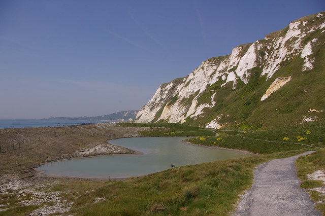
English: Samphire Hoe. Formed out of spoil from the digging of the Channel Tunnel, the western end of Samphire Hoe is now a nature reserve, the highlight being one of the largest colonies of Early Spider Orchids in the country, with over 9000 recorded plants in 2004 (see 804084 for examples). Pictured is one of the lagoons on the site. In the far distance can be seen Folkestone Harbour. |
| Date | |
| Source | From geograph.org.uk |
| Author | Ian Capper |
| Attribution (required by the license) | Ian Capper / Samphire Hoe / |
| Camera location | | View this and other nearby images on: OpenStreetMap |
|---|
_heading:292.00&language=en)
| Object location | | View this and other nearby images on: OpenStreetMap |
|---|
_heading:292.00&language=en)
Licensing

|
This image was taken from the Geograph project collection. See this photograph's page on the Geograph website for the photographer's contact details. The copyright on this image is owned by Ian Capper and is licensed for reuse under the Creative Commons Attribution-ShareAlike 2.0 license.
|
This file is licensed under the Creative Commons Attribution-Share Alike 2.0 Generic license.
Attribution: Ian Capper
- You are free:
- to share – to copy, distribute and transmit the work
- to remix – to adapt the work
- Under the following conditions:
- attribution – You must give appropriate credit, provide a link to the license, and indicate if changes were made. You may do so in any reasonable manner, but not in any way that suggests the licensor endorses you or your use.
- share alike – If you remix, transform, or build upon the material, you must distribute your contributions under the same or compatible license as the original.
File history
Click on a date/time to view the file as it appeared at that time.
| Date/Time | Thumbnail | Dimensions | User | Comment | |
|---|---|---|---|---|---|
| current | 05:53, 20 February 2011 | | 640 × 426 (68 KB) | GeographBot | == {{int:filedesc}} == {{Information |description={{en|1=Samphire Hoe Formed out of spoil from the digging of the Channel Tunnel, the western end of Samphire Hoe is now a nature reserve, the highlight being one of the largest colonies of Early Spider Orch |
File usage
The following pages on the English Wikipedia use this file (pages on other projects are not listed):
Well, that’s interesting to know that Psilotum nudum are known as whisk ferns. Psilotum nudum is the commoner species of the two. While the P. flaccidum is a rare species and is found in the tropical islands. Both the species are usually epiphytic in habit and grow upon tree ferns. These species may also be terrestrial and grow in humus or in the crevices of the rocks.
View the detailed Guide of Psilotum nudum: Detailed Study Of Psilotum Nudum (Whisk Fern), Classification, Anatomy, Reproduction