
Size of this PNG preview of this SVG file: 563 × 600 pixels. Other resolutions: 225 × 240 pixels | 450 × 480 pixels | 721 × 768 pixels | 961 × 1,024 pixels | 1,922 × 2,048 pixels | 1,188 × 1,266 pixels.
Original file (SVG file, nominally 1,188 × 1,266 pixels, file size: 2.06 MB)
| Description |
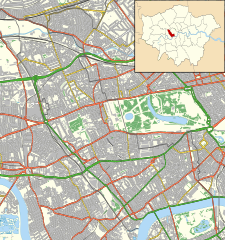
Location map of the Royal Borough of Kensington and Chelsea with the following information shown:
Equirectangular map projection on WGS 84 datum, with N/S stretched 160% Geographic limits:
|
| Date | |
| Source |
|
| Author | Nilfanion |
| Permission (Reusing this file) |
This file is licensed under the Creative Commons Attribution-Share Alike 3.0 Unported license. Attribution: Contains Ordnance Survey data © Crown copyright and database right
|
File history
Click on a date/time to view the file as it appeared at that time.
| Date/Time | Thumbnail | Dimensions | User | Comment | |
|---|---|---|---|---|---|
| current | 23:11, 15 November 2011 | | 1,188 × 1,266 (2.06 MB) | Nilfanion | {{Information |Description=Location map of the Royal Borough of Kensington and Chelsea with the following information shown: *{{legend|#646464|Ward boundaries}} *{{legend|#667fff|Motorways}} *{{legend|#4cb336| |
File usage
The following pages on the English Wikipedia use this file (pages on other projects are not listed):
- Aftermath of the Grenfell Tower fire
- Allen Hall Seminary
- Anglesea Arms, South Kensington
- Bunch of Grapes, Knightsbridge
- Cadogan Pier
- Cale Street
- Carlyle's House
- Chelsea Potter
- Chelsea Town Hall
- Chelsea and Westminster Hospital
- Church of Our Most Holy Redeemer and St Thomas More, Chelsea
- Cromwell Hospital
- Design Museum
- Elgin, Ladbroke Grove
- Fox and Pheasant
- Gloucester Arms, Kensington
- Goat, Chelsea
- Grenfell Tower
- Grenfell Tower fire
- Hesper Mews
- Holland House
- Hollywood Road, Brompton
- Kensington Town Hall, London
- Leighton House Museum
- Lister Hospital, Chelsea
- London Cage
- Mallord Street
- Michelin House
- Old Town Hall, Kensington
- Portobello Road
- Prince of Teck, Earl's Court
- Princess Beatrice Hospital
- Princess Louise Hospital
- Restaurant Gordon Ramsay
- Royal Brompton Hospital
- Royal Marsden Hospital
- Scarsdale Tavern
- St Charles' Hospital
- St Mary Abbots Hospital
- The Cross Keys, Chelsea
- The Goat, Kensington
- The Greyhound, Kensington
- The Hansom Cab
- The Hollywood Arms, Kensington
- The King's Head and Eight Bells
- The Phene
- The Tower House
- The World's End, Chelsea
- Trellick Tower
- Victoria Hospital for Children
- Windsor Castle, Kensington
- Zetland Arms
- User:Chickstarr404/Gather lists/14617 – "Melbourne" by Lord David Cecil
- User:Scott/HH
- Module:Location map/data/United Kingdom London Kensington and Chelsea
- Module:Location map/data/United Kingdom London Kensington and Chelsea/doc
Global file usage
The following other wikis use this file:
- Usage on ar.wikipedia.org
- Usage on ceb.wikipedia.org
- Usage on fa.wikipedia.org
- Usage on fr.wikipedia.org
- Usage on ja.wikipedia.org
- Usage on kn.wikipedia.org
- Usage on my.wikipedia.org
- Usage on sco.wikipedia.org
- Usage on si.wikipedia.org
- Usage on th.wikipedia.org
- Usage on tr.wikipedia.org
- Usage on war.wikipedia.org
- Usage on zh.wikipedia.org
Well, that’s interesting to know that Psilotum nudum are known as whisk ferns. Psilotum nudum is the commoner species of the two. While the P. flaccidum is a rare species and is found in the tropical islands. Both the species are usually epiphytic in habit and grow upon tree ferns. These species may also be terrestrial and grow in humus or in the crevices of the rocks.
View the detailed Guide of Psilotum nudum: Detailed Study Of Psilotum Nudum (Whisk Fern), Classification, Anatomy, Reproduction