
Size of this PNG preview of this SVG file: 562 × 600 pixels. Other resolutions: 225 × 240 pixels | 450 × 480 pixels | 719 × 768 pixels | 959 × 1,024 pixels | 1,919 × 2,048 pixels | 1,334 × 1,424 pixels.
Original file (SVG file, nominally 1,334 × 1,424 pixels, file size: 1.56 MB)
| Description |
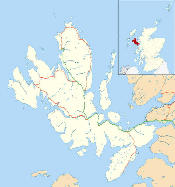
Blank map of the Isle of Skye, UK, as well as the adjacent islands, with the following information shown:
Equirectangular map projection on WGS 84 datum, with N/S stretched 180% Geographic limits:
|
| Date | |
| Source |
|
| Author | Nilfanion, created using Ordnance Survey data |
| Permission (Reusing this file) |
This file is licensed under the Creative Commons Attribution-Share Alike 3.0 Unported license. Attribution: Contains Ordnance Survey data © Crown copyright and database right
|
| Other versions | File:Isle of Skye UK blank map.svg - Blank map |
File history
Click on a date/time to view the file as it appeared at that time.
| Date/Time | Thumbnail | Dimensions | User | Comment | |
|---|---|---|---|---|---|
| current | 11:20, 4 February 2011 | | 1,334 × 1,424 (1.56 MB) | Nilfanion | {{Information |Description=Blank map of the Isle of Skye, UK, as well as the adjacent islands, with the following information shown: *Coastline, lakes and rivers *Roads and railways *Urban areas Equirectangular map projection on WGS 84 |
File usage
More than 100 pages use this file. The following list shows the first 100 pages that use this file only. A full list is available.
- Achachork
- Aird of Sleat
- Ardvasar
- Armadale, Skye
- Ashaig
- Bernisdale
- Boreraig
- Bornesketaig
- Borreraig
- Borrodale
- Borve, Skye
- Bracadale
- Broadford, Skye
- Broadford Airfield
- Brogaig
- Bualintur
- Camastianavaig
- Camasunary
- Camuscross
- Carbost, Loch Harport
- Carbost, Trotternish
- Claigan
- Colbost
- Drumfearn
- Drynoch
- Dun Ardtreck
- Dun Beag
- Dun Ringill
- Dunan, Skye
- Duntulm
- Dunvegan
- Dunvegan Castle
- Edinbane
- Elgol
- Ellishadder
- Eynort
- Eyre, Skye
- Fasach
- Feorlig
- Ferindonald
- Feriniquarrie
- Fiskavaig
- Flashader
- Flodigarry
- Galtrigill
- Garafad
- Geary, Skye
- Gedintailor
- Gillen, Skye
- Glendale, Skye
- Halistra
- Harlosh
- Harrapool
- Heaste
- Hungladder
- Idrigill
- Isle of Skye
- Isleornsay
- Kensaleyre
- Kilbride, Skye
- Kilmaluag
- Kilmarie
- Kilmore, Skye
- Kilmuir, Skye
- Kilvaxter
- Kingsburgh, Skye
- Kyleakin
- Kylerhea
- Lealt, Skye
- Lower Breakish
- Luib, Skye
- Mackinnon Memorial Hospital
- Milovaig
- Mugeary
- Ollach
- Ose, Skye
- Peinachorran
- Peinlich
- Portnalong
- Portree
- Ramasaig
- Roag, Skye
- Sconser
- Skeabost
- Sligachan
- Staffin
- Stein, Skye
- Struan, Skye
- Suladale
- Talisker
- Tarskavaig
- Teangue
- Torrin
- Totaig
- Tote, Skye
- Treaslane
- Trumpan
- Uig, Snizort
- Uigshader
- Ullinish
View more links to this file.
Global file usage
The following other wikis use this file:
- Usage on ar.wikipedia.org
- Usage on ceb.wikipedia.org
- Usage on de.wikipedia.org
- Usage on es.wikipedia.org
- Usage on fa.wikipedia.org
- Usage on fr.wikipedia.org
- Usage on fy.wikipedia.org
- Usage on ja.wikipedia.org
- Usage on kn.wikipedia.org
- Usage on nl.wikipedia.org
- Usage on sco.wikipedia.org
- Usage on si.wikipedia.org
- Usage on tr.wikipedia.org
- Usage on uz.wikipedia.org
- Usage on war.wikipedia.org
- Usage on zh.wikipedia.org
Well, that’s interesting to know that Psilotum nudum are known as whisk ferns. Psilotum nudum is the commoner species of the two. While the P. flaccidum is a rare species and is found in the tropical islands. Both the species are usually epiphytic in habit and grow upon tree ferns. These species may also be terrestrial and grow in humus or in the crevices of the rocks.
View the detailed Guide of Psilotum nudum: Detailed Study Of Psilotum Nudum (Whisk Fern), Classification, Anatomy, Reproduction