
Size of this preview: 452 × 599 pixels. Other resolutions: 181 × 240 pixels | 483 × 640 pixels.
Original file (483 × 640 pixels, file size: 148 KB, MIME type: image/jpeg)
Summary
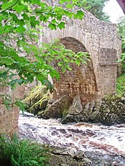
| Description | Feugh Cascades flowing under the Bridge of Feugh, Aberdeenshire, Great Britain |
| Date | |
| Source | From geograph.org.uk; transferred by User:Multichill using geograph_org2commons. |
| Author | C Michael Hogan |
| Permission (Reusing this file) |
Creative Commons Attribution Share-alike license 2.0 |
| Attribution (required by the license) | C Michael Hogan / Feugh Cascades flowing under the Bridge of Feugh / |
| Camera location | | View this and other nearby images on: OpenStreetMap |
|---|
| Object location | | View this and other nearby images on: OpenStreetMap |
|---|
_region:GB-GBN_heading:45.00&language=en)
Licensing

|
This image was taken from the Geograph project collection. See this photograph's page on the Geograph website for the photographer's contact details. The copyright on this image is owned by C Michael Hogan and is licensed for reuse under the Creative Commons Attribution-ShareAlike 2.0 license.
|
This file is licensed under the Creative Commons Attribution-Share Alike 2.0 Generic license.
Attribution: C Michael Hogan
- You are free:
- to share – to copy, distribute and transmit the work
- to remix – to adapt the work
- Under the following conditions:
- attribution – You must give appropriate credit, provide a link to the license, and indicate if changes were made. You may do so in any reasonable manner, but not in any way that suggests the licensor endorses you or your use.
- share alike – If you remix, transform, or build upon the material, you must distribute your contributions under the same or compatible license as the original.
File history
Click on a date/time to view the file as it appeared at that time.
| Date/Time | Thumbnail | Dimensions | User | Comment | |
|---|---|---|---|---|---|
| current | 17:31, 24 December 2009 | | 483 × 640 (148 KB) | File Upload Bot (Magnus Manske) | == Summary == {{Information |Description=Feugh Cascades flowing under the Bridge of Feugh |Source=From [http://www.geograph.org.uk/photo/534581 geograph.org.uk]; transferd by User:Multichill using [http://toolserver.org/~magnus/geograph_org2commons.ph |
File usage
The following pages on the English Wikipedia use this file (pages on other projects are not listed):
Global file usage
The following other wikis use this file:
- Usage on ceb.wikipedia.org
- Usage on da.wikipedia.org
- Usage on gd.wikipedia.org
- Usage on www.wikidata.org
Well, that’s interesting to know that Psilotum nudum are known as whisk ferns. Psilotum nudum is the commoner species of the two. While the P. flaccidum is a rare species and is found in the tropical islands. Both the species are usually epiphytic in habit and grow upon tree ferns. These species may also be terrestrial and grow in humus or in the crevices of the rocks.
View the detailed Guide of Psilotum nudum: Detailed Study Of Psilotum Nudum (Whisk Fern), Classification, Anatomy, Reproduction