
Size of this preview: 800 × 509 pixels. Other resolutions: 320 × 204 pixels | 640 × 407 pixels | 1,024 × 652 pixels | 1,321 × 841 pixels.
Original file (1,321 × 841 pixels, file size: 1.01 MB, MIME type: image/png)
Summary
| Description |
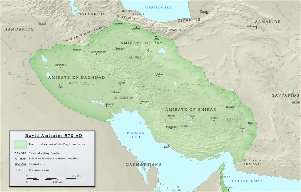
English: Map of the three emirates under control of the Buyid dynasty ca. 970 CE |
| Date | |
| Source |
(Original text : Own work. Data sources :
|
| Author | ro4444 |
| Permission (Reusing this file) |
. Original uploader was Ro4444 at en.wikipedia CC-BY-SA-3.0; Released under the GNU Free Documentation License; Released into the public domain (by the author). |
| Other versions | العربيَّة |
Licensing
| This work has been released into the public domain by its author, Ro4444 at English Wikipedia. This applies worldwide. In some countries this may not be legally possible; if so: Ro4444 grants anyone the right to use this work for any purpose, without any conditions, unless such conditions are required by law. |
Ro4444 at English Wikipedia, the copyright holder of this work, hereby publishes it under the following licenses:
This file is licensed under the Creative Commons Attribution-Share Alike 3.0 Unported license.
Attribution: Ro4444 at English Wikipedia
- You are free:
- to share – to copy, distribute and transmit the work
- to remix – to adapt the work
- Under the following conditions:
- attribution – You must give appropriate credit, provide a link to the license, and indicate if changes were made. You may do so in any reasonable manner, but not in any way that suggests the licensor endorses you or your use.
- share alike – If you remix, transform, or build upon the material, you must distribute your contributions under the same or compatible license as the original.

|
Permission is granted to copy, distribute and/or modify this document under the terms of the GNU Free Documentation License, Version 1.2 or any later version published by the Free Software Foundation; with no Invariant Sections, no Front-Cover Texts, and no Back-Cover Texts. A copy of the license is included in the section entitled GNU Free Documentation License. |
You may select the license of your choice.
Original upload log
The original description page was here. All following user names refer to en.wikipedia.
- 2010-09-27 05:16 Ro4444 1321×841× (1059156 bytes) == Summary == == Description == {{Information |Description= {{en| Political map in English of the Buyids in 970 A.D.}} |Source=Own work. {{clr}} Data sources : * Background map : [[Topographic map#Global 1-kilometer map]] (SRTM3 v.2) (public domain){{clr}
File history
Click on a date/time to view the file as it appeared at that time.
| Date/Time | Thumbnail | Dimensions | User | Comment | |
|---|---|---|---|---|---|
| current | 15:24, 25 July 2012 | | 1,321 × 841 (1.01 MB) | Cplakidas | {{Information |Description={{en|Map of the three emirates under control of the en:Buyid dynasty ca. 970 CE}} |Source=Transferred from [http://en.wikipedia.org en.wikipedia]<br/> (Original text : ''Own work. Data sources : * Background map : [[:en... |
File usage
The following pages on the English Wikipedia use this file (pages on other projects are not listed):
- 'Adud al-Dawla
- Abu Ishaq Ibrahim (Buyid)
- Abu Kalijar
- Abu Mansur Fulad Sutun
- Abu Sa'd Khusrau Shah
- Al-Malik al-Rahim
- Baha al-Dawla
- Buyid dynasty
- Diya al-Dawla
- Fakhr al-Dawla
- Greater Iran
- History of Shia Islam
- Ilam province
- Imad al-Dawla
- Izz al-Dawla
- Jalal al-Dawla
- Kerman Seljuk Sultanate
- Majd al-Dawla
- Mu'ayyad al-Dawla
- Mu'izz al-Dawla
- Musharrif al-Dawla
- Qawam al-Dawla
- Rukn al-Dawla
- Sama' al-Dawla
- Samsam al-Dawla
- Shams al-Dawla
- Sharaf al-Dawla
- Sultan al-Dawla
- Taj al-Dawla
- User:Chickstarr404/Gather lists/4913 – Samarkland by Amin Maalouf
- User:Falcaorib/Medieval Empires (800-1000 AD)
- Template:Buyid dynasty
Global file usage
The following other wikis use this file:
- Usage on arz.wikipedia.org
- Usage on ast.wikipedia.org
- Usage on azb.wikipedia.org
- Usage on az.wikipedia.org
- Usage on ba.wikipedia.org
- Usage on be.wikipedia.org
- Usage on bg.wikipedia.org
- Usage on bn.wikipedia.org
- Usage on ckb.wikipedia.org
- Usage on de.wikipedia.org
- Usage on diq.wikipedia.org
- Usage on el.wikipedia.org
- Usage on eo.wikipedia.org
- Usage on es.wikipedia.org
- Usage on fa.wikipedia.org
- Usage on fa.wikibooks.org
- Usage on fi.wikipedia.org
- Usage on ha.wikipedia.org
- Usage on he.wikipedia.org
- Usage on hi.wikipedia.org
- Usage on hu.wikipedia.org
- Usage on hy.wikipedia.org
- Usage on id.wikipedia.org
- Usage on it.wikipedia.org
- Usage on ja.wikipedia.org
- Usage on ko.wikipedia.org
- Usage on ku.wikipedia.org
- Usage on lt.wikipedia.org
View more global usage of this file.
Well, that’s interesting to know that Psilotum nudum are known as whisk ferns. Psilotum nudum is the commoner species of the two. While the P. flaccidum is a rare species and is found in the tropical islands. Both the species are usually epiphytic in habit and grow upon tree ferns. These species may also be terrestrial and grow in humus or in the crevices of the rocks.
View the detailed Guide of Psilotum nudum: Detailed Study Of Psilotum Nudum (Whisk Fern), Classification, Anatomy, Reproduction