Drenchia
| |
|---|---|
| Comune di Drenchia | |
Location of Drenchia  | |
 Drenchia Location of Drenchia in Italy  Drenchia Drenchia (Friuli-Venezia Giulia) | |
| Coordinates: 46°11′N 13°39′E / 46.183°N 13.650°E | |
| Country | Italy |
| Region | Friuli-Venezia Giulia |
| Province | Udine (UD) |
| Frazioni | Clabuzzaro/Brieg, Crai/Kraj, Cras/Kras (municipal seat), Drenchia inferiore/Dolenja Dreka, Drenchia Superiore/Gorenja Dreka, Lase/Laze, Malinsche/Malinske, Obenetto/Dubenije, Obranche/Obranke, Oznebrida/Ocnebardo, Paciuch/Pačuh, Peternel/Peternel, Prapotnizza/Praponca, San Volfango/Svet Štuoblank, Trinco/Trinko, Trusgne/Trušnje, Zavart/Zavart, Zuodar/Cuoder. |
| Government | |
| • Mayor | Mario Zufferli (Lista civica) |
| Area | |
| • Total | 13.8 km2 (5.3 sq mi) |
| Elevation | 663 m (2,175 ft) |
| Population (Dec. 2010)[2] | |
| • Total | 141 |
| • Density | 10/km2 (26/sq mi) |
| Time zone | UTC+1 (CET) |
| • Summer (DST) | UTC+2 (CEST) |
| Postal code | 33040 |
| Dialing code | 0432 |
| Patron saint | Assumption of Mary |
| Saint day | August 15 |
| Website | Institutional website |
Drenchia (Slovene: Dreka; Friulian: Drencje) is a comune (municipality) in the Regional decentralization entity of Udine in the Italian region of Friuli-Venezia Giulia, located about 60 kilometres (37 mi) north of Trieste and about 35 kilometres (22 mi) northeast of Udine, on the border with Slovenia. Drenchia is located on the western slopes of the Kolovrat Range, dividing Italy from Slovenia, and borders the following municipalities: Grimacco, Kanal ob Soči (Slovenia), Kobarid (Slovenia), and Tolmin (Slovenia).
Drenchia localities include Clabuzzaro/Brieg, Crai/Kraj, Cras/Kras, Drenchia inferiore/Dolenja Dreka, Drenchia Superiore/Gorenja Dreka, Lase/Laze, Malinsche/Malinske, Obenetto/Dubenije, Obranche/Obranke, Oznebrida/Ocnebardo, Paciuch/Pačuh, Peternel/Peternel, Prapotnizza/Praponca, San Volfango/Svet Štuoblank, Trinco/Trinko, Trusgne/Trušnje, Zavart/Zavart, Zuodar/Cuoder.[3] The municipal hall is located in Cras.
As of 31 December 2010, it had a population of 141 and an area of 13.8 square kilometres (5.3 sq mi).[4]
Ethnic composition
[edit]97% of the population in Drenchia were Slovenes according to the census 1971.[5]
Demographic decline
[edit]
References
[edit]- ^ "Superficie di Comuni Province e Regioni italiane al 9 ottobre 2011". Italian National Institute of Statistics. Retrieved 16 March 2019.
- ^ "Popolazione Residente al 1° Gennaio 2018". Italian National Institute of Statistics. Retrieved 16 March 2019.
- ^ en.comuni-italiani.it, Municipalities in Italy
- ^ All demographics and other statistics: Italian statistical institute Istat.
- ^ Thomas, Lee; Lokar A. (1977) Socioeconomic structure of the Slovene population in Italy, Slovene Studies, Chicago, Illinois, p.28.
Gallery
[edit]-
 Peternel village
 -
 Clabuzzaro village
 -
 The church of San Volfango
 -
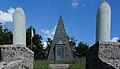 The war memorial of San Volfango


Well, that’s interesting to know that Psilotum nudum are known as whisk ferns. Psilotum nudum is the commoner species of the two. While the P. flaccidum is a rare species and is found in the tropical islands. Both the species are usually epiphytic in habit and grow upon tree ferns. These species may also be terrestrial and grow in humus or in the crevices of the rocks.
View the detailed Guide of Psilotum nudum: Detailed Study Of Psilotum Nudum (Whisk Fern), Classification, Anatomy, Reproduction