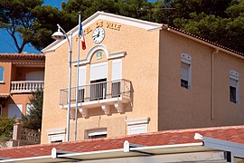
Carry-le-Rouet
Carri lo Roet (Occitan) | |
|---|---|
 Carry-le-Rouet Town Hall | |
| Coordinates: 43°19′59″N 5°09′10″E / 43.3331°N 5.1528°E | |
| Country | France |
| Region | Provence-Alpes-Côte d'Azur |
| Department | Bouches-du-Rhône |
| Arrondissement | Istres |
| Canton | Marignane |
| Intercommunality | Aix-Marseille-Provence |
| Government | |
| • Mayor (2020–2026) | René-Francis Carpentier[1] |
| Area 1 | 10 km2 (4 sq mi) |
| Population (2021)[2] | 5,708 |
| • Density | 570/km2 (1,500/sq mi) |
| Time zone | UTC+01:00 (CET) |
| • Summer (DST) | UTC+02:00 (CEST) |
| INSEE/Postal code | 13021 /13620 |
| Elevation | 0–178 m (0–584 ft) (avg. 4 m or 13 ft) |
| 1 French Land Register data, which excludes lakes, ponds, glaciers > 1 km2 (0.386 sq mi or 247 acres) and river estuaries. | |
Carry-le-Rouet (French pronunciation: [kaʁi lə ʁwɛ]; Occitan: Carri lo Roet) or simply Carry is a commune in the Bouches-du-Rhône department in the Provence-Alpes-Côte d'Azur region in Southern France. It is a seaside resort 30 kilometres (19 mi) west of Marseille, on the Côte Bleue, reached via motorway A55 then route D5, at the foot of pine-covered hills. It is part of the Aix-Marseille-Provence Metropolis.
Every February, Les Oursinades festival takes place, celebrating the consumption of sea urchins, various shellfish and other seafood.[3]
Transport
[edit]Carry-le-Rouet is served by the Carry-le-Rouet TER PACA railway station (opened in 1915) on the Miramas–L'Estaque railway.
-
TER PACA service at Carry-le-Rouet station in 2010
-
Station building
Demographics
[edit]
|
| ||||||||||||||||||||||||||||||||||||||||||||||||||||||||||||||||||||||||||||||||||||||||||||||||||||||||||||||||||
| Source: EHESS[4] and INSEE (1968–2020)[5] | |||||||||||||||||||||||||||||||||||||||||||||||||||||||||||||||||||||||||||||||||||||||||||||||||||||||||||||||||||
Personalities
[edit]- Comic actor Fernandel, who built his family's house above the beach in the 1930s.
- The singer Nina Simone, who lived out the last years of her life in Carry-le-Rouet and died at her home in 2003.
Sister cities
[edit]See also
[edit]References
[edit]- ^ "Répertoire national des élus: les maires". data.gouv.fr, Plateforme ouverte des données publiques françaises (in French). 2 December 2020.
- ^ "Populations légales 2021" (in French). The National Institute of Statistics and Economic Studies. 28 December 2023.
- ^ "Les Oursinades festival". Carry-le-Route Office de Tourisme. Retrieved 7 August 2020.
- ^ Des villages de Cassini aux communes d'aujourd'hui: Commune data sheet Carry-le-Rouet, EHESS (in French).
- ^ Population en historique depuis 1968, INSEE
External links
[edit]- Official website (in French)


Well, that’s interesting to know that Psilotum nudum are known as whisk ferns. Psilotum nudum is the commoner species of the two. While the P. flaccidum is a rare species and is found in the tropical islands. Both the species are usually epiphytic in habit and grow upon tree ferns. These species may also be terrestrial and grow in humus or in the crevices of the rocks.
View the detailed Guide of Psilotum nudum: Detailed Study Of Psilotum Nudum (Whisk Fern), Classification, Anatomy, Reproduction