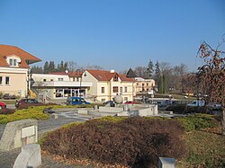
Slavičín | |
|---|---|
 Horní Square | |
| Coordinates: 49°5′17″N 17°52′25″E / 49.08806°N 17.87361°E | |
| Country | |
| Region | Zlín |
| District | Zlín |
| First mentioned | 1141 |
| Government | |
| • Mayor | Tomáš Chmela |
| Area | |
| • Total | 33.61 km2 (12.98 sq mi) |
| Elevation | 350 m (1,150 ft) |
| Population (2024-01-01)[1] | |
| • Total | 6,224 |
| • Density | 190/km2 (480/sq mi) |
| Time zone | UTC+1 (CET) |
| • Summer (DST) | UTC+2 (CEST) |
| Postal code | 763 21 |
| Website | www |
Slavičín (Czech pronunciation: [ˈslavɪtʃiːn]) is a town in Zlín District in the Zlín Region of the Czech Republic. It has about 6,200 inhabitants.
Administrative parts
[edit]The villages of Divnice, Hrádek na Vlárské dráze and Nevšová are administrative parts of Slavičín.
Etymology
[edit]There are several theories about the origin of the name. The name could be derived from slavík (i.e. 'nightingale'), or there may be a connection with the Slavník dynasty. According to local legend, the name is derived from slavný čin (meaning 'glorious deed').[2]
Geography
[edit]Slavičín is located about 24 kilometres (15 mi) southeast of Zlín. It lies in the Vizovice Highlands. The highest point is at 532 m (1,745 ft) above sea level. The Říka stream flows through the town. The entire municipal territory lies within the Bílé Karpaty Protected Landscape Area.
History
[edit]The first written mention of Slavičín is in a deed of Bishop Jindřich Zdík from 1141.[2] For centuries, it was mostly an agricultural village where the craft did not flourish much. In 1860 a tannery was founded here, which was later expanded by a shoe factory. In 1936, an engineering company was established and Slavičín became an industrial village. After the World War II Slavičín further expanded, and in 1964 it became a town.[3]
Demographics
[edit]
|
|
| ||||||||||||||||||||||||||||||||||||||||||||||||||||||
| Source: Censuses[4][5] | ||||||||||||||||||||||||||||||||||||||||||||||||||||||||
Transport
[edit]Slavičín is located on the railway line Bylnice–Bojkovice.[6]
Sights
[edit]
The Church of Saint Adalbert is the oldest building in the town. The original church was from the 13th century. After it was destroyed by a fire, this cemetery church completely rebuilt in the Baroque style in 1897.[7]
The Slavičín Castle was built in the Baroque style in 1750. Today it serves as a restaurant.[8]
Notable people
[edit]- Lumír Krejčí (born 1972), biochemist
- Tomáš Řepka (born 1974), footballer
- Tomáš Polách (born 1977), footballer
- Lenny Trčková (born 1978), presenter and model
- Petra Polášková (born 1979), footballer
- Stanislav Polčák (born 1980), politician
- Aleš Urbánek (born 1980), footballer
- Zdeněk Hřib (born 1981), politician, Mayor of Prague
Twin towns – sister cities
[edit] Horná Súča, Slovakia
 Horné Srnie, Slovakia
 Nová Dubnica, Slovakia
 Uhrovec, Slovakia
References
[edit]- ^ "Population of Municipalities – 1 January 2024". Czech Statistical Office. 2024-05-17.
- ^ a b "První písemné zmínky o Slavičínsku" (in Czech). Město Slavičín. Retrieved 2023-04-11.
- ^ "Historie Slavičína" (in Czech). Město Slavičín. Retrieved 2023-04-11.
- ^ "Historický lexikon obcí České republiky 1869–2011 – Okres Zlín" (in Czech). Czech Statistical Office. 2015-12-21. pp. 5–6.
- ^ "Population Census 2021: Population by sex". Public Database. Czech Statistical Office. 2021-03-27.
- ^ "Detail stanice Slavičín" (in Czech). České dráhy. Retrieved 2024-05-21.
- ^ "Kostel sv. Vojtěcha" (in Czech). Město Slavičín. Retrieved 2022-01-03.
- ^ "Zámek Slavičín" (in Czech). Město Slavičín. Retrieved 2022-01-03.
- ^ "Partnerská města a obce" (in Czech). Město Slavičín. Retrieved 2022-10-04.


