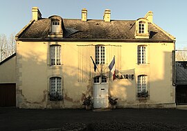
Les Moutiers-en-Cinglais | |
|---|---|
 Town hall | |
| Coordinates: 49°01′47″N 0°25′39″W / 49.0297°N 0.4275°W | |
| Country | France |
| Region | Normandy |
| Department | Calvados |
| Arrondissement | Caen |
| Canton | Le Hom |
| Intercommunality | Cingal-Suisse Normande |
| Government | |
| • Mayor (2020–2026) | Gérard Allain[1] |
| Area 1 | 6.75 km2 (2.61 sq mi) |
| Population (2021)[2] | 521 |
| • Density | 77/km2 (200/sq mi) |
| Time zone | UTC+01:00 (CET) |
| • Summer (DST) | UTC+02:00 (CEST) |
| INSEE/Postal code | 14458 /14220 |
| Elevation | 15–186 m (49–610 ft) (avg. 114 m or 374 ft) |
| 1 French Land Register data, which excludes lakes, ponds, glaciers > 1 km2 (0.386 sq mi or 247 acres) and river estuaries. | |
Les Moutiers-en-Cinglais (French pronunciation: [le mutje ɑ̃ sɛ̃ɡlɛ] ) is a commune in the department of Calvados in the Normandy region in northwestern France.
Geography[edit]
The commune is part of the area known as Suisse Normande.[3]
The commune is made up of the following collection of villages and hamlets, La Bagotière, L'Église, La Couture and Les Moutiers-en-Cinglais.[4]
The River Orne plus three streams The Neumer, The Trois Cours, and La Grande Vallee are the four watercourses running through the commune.[5]
Population[edit]
| Year | Pop. | ±% |
|---|---|---|
| 1962 | 231 | — |
| 1968 | 232 | +0.4% |
| 1975 | 252 | +8.6% |
| 1982 | 315 | +25.0% |
| 1990 | 350 | +11.1% |
| 1999 | 350 | +0.0% |
| 2008 | 417 | +19.1% |
Points of interest[edit]
National heritage sites[edit]
- Château de Villeray is an eighteenth century chateau which was listed as a monument in 2005.[6]
Notable People[edit]
- Jacques Le Roy Ladurie - (1902 – 1988) an agriculturalist and politician is buried here.[7]
- Emmanuel Le Roy Ladurie - (1929 – 2023) a French historiane, was born here.[8]
- Roger Fauroux - (1926 - 2021) a French politician and civil servant who served as Minister of Industry and Regional Planning from 1988 to 1991 is buried here.[9]
See also[edit]
References[edit]
- ^ "Répertoire national des élus: les maires" (in French). data.gouv.fr, Plateforme ouverte des données publiques françaises. 13 September 2022.
- ^ "Populations légales 2021". The National Institute of Statistics and Economic Studies. 28 December 2023.
- ^ "Map of Suiss Normande" (PDF).
- ^ a b "Les Moutiers-en-Cinglais · 14220, France". Les Moutiers-en-Cinglais · 14220, France.
- ^ Sandre. "Fiche cours d'eau - L'Orne (I2--0200)".
- ^ "Château de Villeray aux Moutiers-en-Cinglais - PA14000056". monumentum.fr.
- ^ "Jacques Le Roy Ladurie (1902-1988) - Find a Grave..." www.findagrave.com.
- ^ "Emmanuel Le Roy Ladurie, historian of the downtrodden, dies at 94". The Washington Post.
- ^ "2021 - Cimetières de France et d'ailleurs". www.landrucimetieres.fr.


