Content deleted Content added
KhndzorUtogh (talk | contribs) unreliable source |
Partial rv, added archive link |
||
| Line 21: | Line 21: | ||
| footnotes = {{GEOnet2|32FA881E6B303774E0440003BA962ED3}} |
| footnotes = {{GEOnet2|32FA881E6B303774E0440003BA962ED3}} |
||
}} |
}} |
||
'''Pokr Masrik''' ({{lang-hy|Փոքր Մասրիկ}}) is a village in the [[Vardenis Municipality]] of the [[Gegharkunik Province]] of [[Armenia]]. From 1988 and onward, Armenian refugees from Azerbaijan settled in the village.<ref name="GegharkunikSotk">{{Cite web |title=ՓՈՔՐ ՄԱՍՐԻԿ |
'''Pokr Masrik''' ({{lang-hy|Փոքր Մասրիկ}}) is a village in the [[Vardenis Municipality]] of the [[Gegharkunik Province]] of [[Armenia]]. [[Azerbaijanis]] lived in the village prior to their [[Azerbaijanis in Armenia#Nagorno-Karabakh_conflict|exodus]] from Armenia after the outbreak of the [[Nagorno-Karabakh conflict]]. From 1988 and onward, Armenian refugees from Azerbaijan settled in the village.<ref name="GegharkunikSotk">{{Cite web |title=ՓՈՔՐ ՄԱՍՐԻԿ |
||
|url=https://gegharkunik.am/node/124 |url-status= |
|url=https://gegharkunik.am/node/124 |url-status=dead |archive-url=https://web.archive.org/web/20220722055437/https://gegharkunik.am/node/124 |archive-date=22 July 2022 |access-date=17 February 2021|website=gegharkunik.am}}</ref> The village is located close to [[Mets Masrik]] ({{lit|Big Masrik}}). |
||
== History == |
== History == |
||
Revision as of 23:58, 26 February 2023
40°15′29″N 45°43′21″E / 40.25806°N 45.72250°E
Pokr Masrik
Փոքր Մասրիկ | |
|---|---|
 St. Nshan chapel in Pokr Masrik | |
 Pokr Masrik  Pokr Masrik | |
| Coordinates: 40°15′29″N 45°43′21″E / 40.25806°N 45.72250°E | |
| Country | Armenia |
| Province | Gegharkunik |
| Municipality | Vardenis |
| Population | |
| • Total | 626 |
| Time zone | UTC+4 (AMT) |
| Pokr Masrik at GEOnet Names Server | |
Pokr Masrik (Armenian: Փոքր Մասրիկ) is a village in the Vardenis Municipality of the Gegharkunik Province of Armenia. Azerbaijanis lived in the village prior to their exodus from Armenia after the outbreak of the Nagorno-Karabakh conflict. From 1988 and onward, Armenian refugees from Azerbaijan settled in the village.[2] The village is located close to Mets Masrik (lit. 'Big Masrik').
History
The village has a 12th-century church.
Demographics
The population of the town consisted of 227 Muslims in 1831 rising to 1,200 in 1897 and to 1,375 by 1916.[3]
Gallery
-
 St. Nshan chapel and khachkars
 -
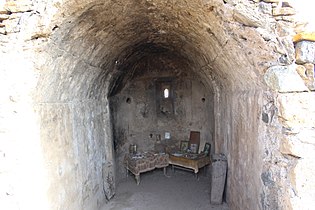 St. Nshan chapel interior


References
- ^ Statistical Committee of Armenia. "The results of the 2011 Population Census of Armenia" (PDF).
- ^ "ՓՈՔՐ ՄԱՍՐԻԿ". gegharkunik.am. Archived from the original on 22 July 2022. Retrieved 17 February 2021.
- ^ Korkotyan, Zaven (1932). Խորհրդային Հայաստանի բնակչությունը վերջին հարյուրամյակում (1831-1931) [The population of Soviet Armenia in the last century (1831–1931)] (PDF) (in Armenian). Yerevan: Pethrat. Archived from the original (PDF) on 2 February 2022.
External links
- Report of the results of the 2001 Armenian Census, Statistical Committee of Armenia
- Kiesling, Brady (June 2000). Rediscovering Armenia: An Archaeological/Touristic Gazetteer and Map Set for the Historical Monuments of Armenia (PDF). Archived (PDF) from the original on 6 November 2021.
