| Ukelayat Range | |
|---|---|
| хребет Укэлаят | |
 The range stretching south of the Ukelayat river valley | |
| Highest point | |
| Peak | Ledyanaya |
| Elevation | 2,562 m (8,406 ft)[1] |
| Coordinates | 61°53′18.60″N 171°10′12.72″E / 61.8885000°N 171.1702000°E |
| Dimensions | |
| Length | 150 km (93 mi) E/W |
| Width | 40 km (25 mi) N/S |
| Geography | |
 Ukelayat Range Location in Kamchatka Krai  Ukelayat Range Ukelayat Range (Far Eastern Federal District) | |
| Location | Kamchatka Krai, Russia |
| Range coordinates | 61°45′N 171°20′E / 61.750°N 171.333°E |
| Parent range | Koryak Highlands East Siberian Mountains |
| Geology | |
| Orogeny | Alpine orogeny |
| Climbing | |
| Easiest route | From Khatyrka |
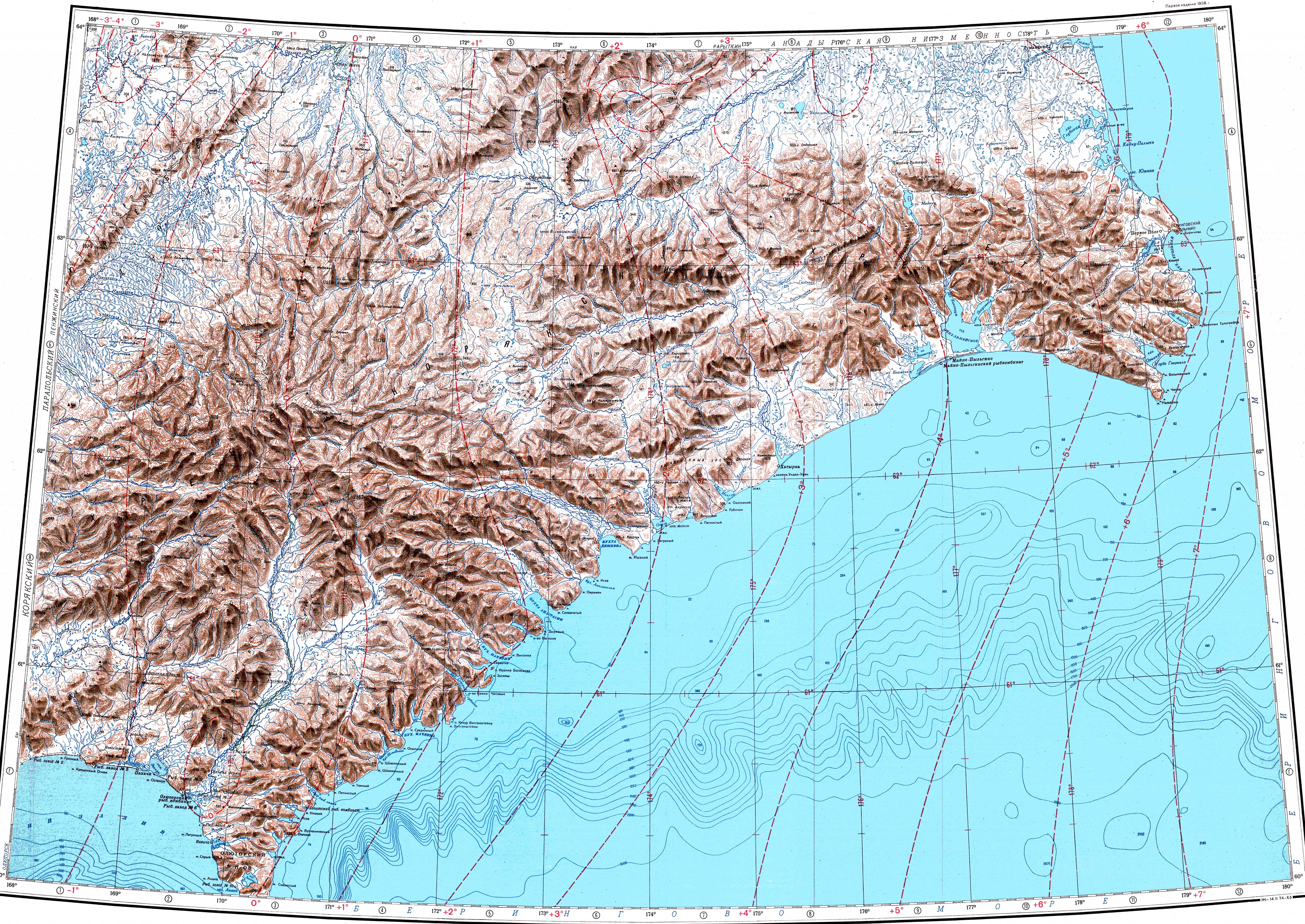
The Ukelayat Range (Russian: хребет Укэлаят)[2] is a range of mountains in Kamchatka Krai, Russian Far East. The range is part of the Koryak Highland system and administratively it belongs to Olyutorsky District.[3]
The name of the range comes from the Koryak "vukvylgayat" (Вуквылгаят), meaning "rock/fall".[4]
Geography[edit]
The Ukelayat Range rises above the southern side of the valley of the Ukelayat river. It stretches in a roughly east–west direction with its eastern end close to the Bering Sea, between Dezhnyov Bay and Anastasii Bay. To the south rises the Snegovoy Range and to the north, above the other bank of the Ukelayat river, the Pikas Range.[3][2][5]
The highest point is Ledyanaya, a 2,562 metres (8,406 ft) high rocky peak topped by an ice cap, which is also the highest point of the Koryak Highlands.[6] To the east, not far from the sea, rises 1,295 metres (4,249 ft) high Mt Undyer (гора Ундер).[2]
The Ukelayat Range has also the largest glacier of the highland area, the Slozhny Glacier with a surface of 4.1 square kilometres (2 sq mi). The range includes two of the three major glacier regions of the Koryak Highlands, having 344 glaciers with a total area of 102.5 square kilometres (40 sq mi).[7][8][9]
Flora and fauna[edit]
The mountains are covered with mountain tundra, bare rocky areas, dwarf forests and shrub birches. Willow thickets, with diamondleaf willow, feltleaf willow and Salix krylovii, may be found in some of the river valleys.[10]
The Ukelayat Range provides a habitat for the snow sheep.
See also[edit]
References[edit]
- ^ Рундквист Н. Каприз блуждающего пальца. Корякское нагорье // Широко шагая. — Екатеринбург: Квист, 2014. — 576 с.
- ^ a b c Atlas of Russia
- ^ a b Google Earth
- ^ Leontiev V.V. , Novikova K.A. Toponymic dictionary of the North-East of the USSR / scientific. ed. G. A. Menovshchikov ; FEB AS USSR . North-East complex. Research Institute. Lab. archeology, history and ethnography. - Magadan: Magadan . book. publishing house , 1989. - S. 290. - 456 p. — ISBN 5-7581-0044-7 .
- ^ "Топографска карта P-59_60 - Topographic USSR Chart (in Russian)". Retrieved 21 February 2022.
- ^ Ledyanaya - Peak Visor
- ^ Осипова Г. Б. Корякское нагорье (ледниковая система) ледники и снежники // Научно-популярная энциклопедия «Вода России»
- ^ Рундквист Н. Каприз блуждающего пальца. Корякское нагорье // Широко шагая. — Екатеринбург: Квист, 2014. — 576 с
- ^ Arctic Bibliography, Volume 11, Arctic Institute of North America. p. 827
- ^ V. Yu. Neshataeva, Vegetation cover of the North of the Kamchatka Okrug (Kamchatsky Krai) and its geobotanical zoning // Ecology and geography of plants and plant communities: Proceedings of the IV International Scientific Conference. - Yekaterinburg, 2018. - April 16. — ISBN 978-5-7741-0341-6
External links[edit]
- The Penzhina-West Kamchatka folded zone and the Ukelayat-Sredinnyi block in the structure of the Koryak Highland and Kamchatka
- Mountain - Russia