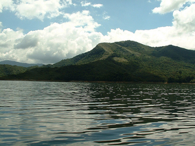
| Tapo-Caparo National Park Parque nacional Tapo-Caparo | |
|---|---|
 | |
| Location | |
| Coordinates | 8°08′N 71°08′W / 8.133°N 71.133°W |
| Area | 2,050 km2 (790 sq mi) |
| Established | 1992 |
The Tapo-Caparo National Park[1] (Spanish: Parque nacional Tapo-Caparo),[2] or National Park Tapo Caparo, is a protected area with national park[3] status in Venezuela.[4] The park covers 2,050 square kilometres (790 sq mi) in the western states of Barinas, Mérida, and Táchira.
The national park was decreed on 14 January 1992 by the government of Carlos Andrés Pérez, with the purpose of protecting the natural environment around the Uribante-Caparo hydroelectric project.
It has a diversity of forests, ferns and mosses, lichens, and fungi. Fauna includes jaguars, toucans, and boas. The park contains numerous gorges and rivers.
See also[edit]
References[edit]
- ^ Parque nacional Tapo-Caparo
- ^ Guía ecoturística de Venezuela (in Spanish). Miro Popić Editor C.A. 1998-01-01.
- ^ Weidmann, K. (2003-01-01). Parques nacionales de Venezuela (in Spanish). Oscar Todtmann. ISBN 9789806028722.
- ^ Boyla, Kerem; Estrada, Angélica; International, BirdLife (2017-03-10). Áreas importantes para la conservación de las aves en los Andes tropicales: sitios prioritarios para la conservación de la biodiversidad (in Spanish). BirdLife International. ISBN 9789978441961.
