| Seven Rivers Formation | |
|---|---|
| Stratigraphic range: | |
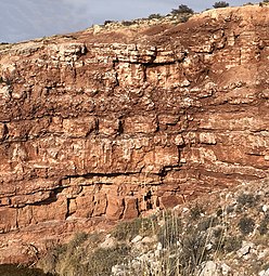
 Cliff of Seven Rivers Formation | |
| Type | Formation |
| Unit of | Artesia Group |
| Underlies | Yates Formation |
| Overlies | Queen Formation |
| Thickness | 400–1,970 feet (120–600 m) |
| Lithology | |
| Primary | Anhydrite |
| Other | Shale, siltstone, dolomite (rock), sandstone |
| Location | |
| Coordinates | 32°29′49″N 104°15′22″W / 32.497°N 104.256°W |
| Region | New Mexico |
| Country | U.S. |
 Seven Rivers Formation (the United States)  Seven Rivers Formation (New Mexico) | |
The Seven Rivers Formation is a geologic formation in southeastern New Mexico and west Texas. It preserves fossils dating back to the late Guadalupian Epoch of the Permian period.[1]
Description[edit]
The formation consists of 400–1,970 feet (120–600 m)[2][1] of anhydrite, with interbeds of shale, dolomite, siltstone, and sandstone. It rests on the Queen Formation and is overlain by the Yates Formation. The Seven Rivers Formation is part of the Artesia Group, which is interpreted as a sequence of shelf rocks of the Capitan reef.[1][3]
History of investigation[edit]
The unit was first named as the Seven Rivers Member of the (now abandoned) Chupadera Formation by Oscar Edward Meinzer and coinvestigators in 1927.[4] In 1937, W.B. Lang assigned the Seven Rivers Member to the (now abandoned) Chalk Bluff Formation and removed its upper beds to the Three Twins Member.[5] The unit was promoted to formation rank and assigned to the Whitehorse Group by Ronald K. DeFord and E. Russel Lloyd in 1940.[6] Norman D. Newell and coinvestigators assigned the formation to the (now abandoned) Carlsbad Group in 1953,[7] and it was assigned to the Artesia Group by D.B. Tait and coinvestigators in 1962.[1]
-
 Shales and gypsum of the Seven Rivers Formation, Bottomless Lakes State Park, New Mexico
 -
 Weathered face of gypsum in the Seven Rivers Formation, Bottomless Lakes State Park, NM. Note the dark, irregular reprecipitated gypsum


See also[edit]
Footnotes[edit]
References[edit]
- DeFord, Ronald K.; Lloyd, E. Russel (1940). "West Texas-New Mexico Symposium: Part I Editorial Introduction". AAPG Bulletin. 24. doi:10.1306/3D933188-16B1-11D7-8645000102C1865D.
- Hayes, P.T.; Koogle, R.L. (1958). "Geology of the Carlsbad Caverns West quadrangle, New Mexico-Texas". U.S. Geological Survey Geologic Quadrangle Map. GQ-112.
- Kues, Barry S. (2006). "Geological studies of the Guadalupe Mountains area, New Mexico and West Texas, to 1928" (PDF). New Mexico Geological Society Field Conference Series. 57: 127–144. Retrieved 20 September 2020.
- Lang, W.B. (1937). "The Permian formations of the Pecos Valley of New Mexico and Texas". American Association of Petroleum Geologists Bulletin. 21 (7): 833–898. doi:10.1306/3D932EDE-16B1-11D7-8645000102C1865D.
- Meinzer, O.E.; Renick, B.C.; Bryan, Kirk (1927). "Geology of No. 3 reservoir site of the Carlsbad Irrigation Project, New Mexico, with respect to water tightness". U.S. Geological Survey Water-Supply Paper. 580-A.
- Newell, N.D.; Rigby, J.K.; Fischer, A.G.; Whiteman, A.J.; Hickox, J.E.; Bradley, J.S. (1953). The Permian reef complex of the Guadalupe Mountains region, Texas and New Mexico; a study in paleoecology. San Francisco: W.H. Freeman and Company. ASIN B001AQT3YC.
- Tait, D.B.; Motts, W.S.; Spitler, M.E. (1962). "Artesia Group of New Mexico and West Texas". American Association of Petroleum Geologists Bulletin. 46 (4): 504–517. doi:10.1306/BC74383B-16BE-11D7-8645000102C1865D.