| Peradayan Forest Reserve | |
|---|---|
 | |
 | |
| Location | Batu Apoi, Temburong |
| Nearest city | Bandar Seri Begawan, Brunei-Muara |
| Coordinates | 4°45′00″N 115°10′00″E / 4.7500000°N 115.1666667°E |
| Area | 2,650 hectares (6,500 acres) |
| Governing body | Temburong District Office |
Peradayan Forest Reserve is a 2,650 hectares (10.2 sq mi) nature reserve in Mukim Batu Apoi, Temburong District, Brunei.[1][2] It is located about 15 km (9.3 mi) from Bangar town.[3]
Perdayan Forest Recreation Park's 1,070 ha (2,600 acres) territory is home to a variety of readily seen wildlife such as Borneo`s native Kijang (deer).[4][3] The reserve encompasses the twin hills of Bukit Perdayan (Perdayan Hill) which rises to 410 m (1,350 ft),[5] and Bukit Patoi at 310 m (1,020 ft) above sea level.[6] The patch of level stone on Bukit Patoi's summit is used as a helipad. It takes about two hours to negotiate the 1.6 km (1 mi) winding trek to the park. Perdayan Forest Recreation Park is situated on the road to Labu, approximately 15 km (9.3 mi) from Bangar town.[7]
Gallery[edit]
-
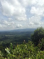 View from Bukit Patoi's peak
 -
 A shelter at Bukit Patoi
 -
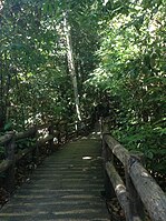 Forest walkway
 -


References[edit]
- ^ The Malayan Forester. 1953. p. 195.
{{cite book}}: CS1 maint: date and year (link) - ^ "BRUNEIresources.com - Peradayan Recreation Forest". www.bruneiresources.com. Retrieved 3 June 2022.
- ^ a b "Peradayan Forest Reserve Travel Guide". www.traveldojo.com. Retrieved 3 June 2022.
- ^ Atiyah, Jeremy (2002). Southeast Asia. Rough Guides. p. 82. ISBN 978-1-85828-893-2.
- ^ "Ficus tarennifolia, Sg Perdayan 02, Brunei". THE FIGS OF BORNEO. 9 March 2019. Retrieved 3 June 2022.
- ^ "Breathtaking Bukit Patoi » Borneo Bulletin Online". Breathtaking Bukit Patoi. 22 November 2019. Retrieved 3 June 2022.
- ^ "Department of Fisheries - Bukit Patoi Forest Recreation Park". www.fisheries.gov.bn. Retrieved 3 June 2022.
External links[edit]
- Bukit Peradayan Recreational Forest; Brunei Resources