Ostřetice | |
|---|---|
 Main road | |
 Ostřetice Location in the Czech Republic | |
| Coordinates: 49°25′21″N 13°20′49″E / 49.42250°N 13.34694°E | |
| Country | |
| Region | Plzeň |
| District | Klatovy |
| First mentioned | 1379 |
| Area | |
| • Total | 5.07 km2 (1.96 sq mi) |
| Elevation | 415 m (1,362 ft) |
| Population (2023-01-01)[1] | |
| • Total | 72 |
| • Density | 14/km2 (37/sq mi) |
| Time zone | UTC+1 (CET) |
| • Summer (DST) | UTC+2 (CEST) |
| Postal code | 339 01 |
| Website | www |
Ostřetice is a municipality and village in Klatovy District in the Plzeň Region of the Czech Republic. It has about 70 inhabitants. The historic centre of the village is well preserved and is protected by law as a village monument zone.
Ostřetice lies approximately 6 kilometres (4 mi) north-east of Klatovy, 36 km (22 mi) south of Plzeň, and 107 km (66 mi) south-west of Prague.
Administrative parts[edit]
The village of Makalovy is an administrative part of Ostřetice.
Demographics[edit]
| Year | Pop. | ±% |
|---|---|---|
| 1869 | 197 | — |
| 1880 | 229 | +16.2% |
| 1890 | 213 | −7.0% |
| 1900 | 222 | +4.2% |
| 1910 | 223 | +0.5% |
| 1921 | 206 | −7.6% |
| 1930 | 198 | −3.9% |
| 1950 | 116 | −41.4% |
| 1961 | 122 | +5.2% |
| 1970 | 103 | −15.6% |
| 1980 | 74 | −28.2% |
| 1991 | 65 | −12.2% |
| 2001 | 59 | −9.2% |
| 2011 | 66 | +11.9% |
| 2021 | 70 | +6.1% |
| Source: Censuses[2][3] | ||
Gallery[edit]
-
 Municipal office
 -
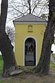 Upper chapel
 -
 The village of Makalovy


References[edit]
- ^ "Population of Municipalities – 1 January 2023". Czech Statistical Office. 2023-05-23.
- ^ "Historický lexikon obcí České republiky 1869–2011 – Okres Klatovy" (in Czech). Czech Statistical Office. 2015-12-21. pp. 21–22.
- ^ "Population Census 2021: Population by sex". Public Database. Czech Statistical Office. 2021-03-27.
External links[edit]
| Authority control databases: National |
|---|