Loretta, Kansas | |
|---|---|
 | |
 Loretta  Loretta | |
| Coordinates: 38°39′13″N 99°10′50″W / 38.65361°N 99.18056°W[1] | |
| Country | United States |
| State | Kansas |
| County | Rush |
| Township | Illinois |
| Founded | 1876 |
| Elevation | 2,001 ft (610 m) |
| Time zone | UTC-6 (CST) |
| • Summer (DST) | UTC-5 (CDT) |
| Area code | 785 |
| FIPS code | 20-42750 |
| GNIS ID | 475395[1] |
Loretta is an unincorporated community in Rush County, Kansas, United States.[1] It is located 7.5 miles (12.1 km) east of Liebenthal, and 3.5 miles (5.6 km) south of Pfeifer.
History[edit]
The community was founded in 1876, and named with the same name as the Illinois township where it was located. Its name evolved over time from Illinois to Marienfeld to Loretta.[2]
Education[edit]
The community is served by Otis–Bison USD 403 public school district.
References[edit]
Further reading[edit]
External links[edit]
- History of Cities in Rush County
- Rush County maps: Current, Historic, KDOT
Municipalities and communities of Rush County, Kansas, United States | ||
|---|---|---|
| Cities | 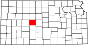 | |
| Unincorporated communities | ||
| Ghost towns | ||
| Townships |
| |