Llano | |
|---|---|
 Llano Location within the state of New Mexico  Llano Llano (the United States) | |
| Coordinates: 36°08′24″N 105°40′54″W / 36.14000°N 105.68167°W | |
| Country | United States |
| State | New Mexico |
| County | Taos |
| Elevation | 8,054 ft (2,455 m) |
| Time zone | UTC-7 (Mountain (MST)) |
| • Summer (DST) | UTC-6 (MDT) |
| ZIP codes | 87543[1] |
| Area code | 575 |
| GNIS feature ID | 908081[2] |
Llano, also known as Llano de San Juan is an unincorporated community located in Taos County, New Mexico, United States. The community is located on New Mexico State Road 73, 2.1 miles (3.4 km) south of Peñasco. It was founded in 1796 after governor Fernando Chacon gave permission for settlement in the valley. A post office was operated from 1898 to 1914, and was then reestablished in 1925.[3]
Llano is located about two miles from the scenic High Road to Taos in the valley of the Rio Santa Barbara on the western side of the Sangre de Cristo mountains.
Gallery[edit]
-
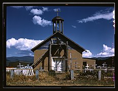 The Catholic Church in Llano.
 -
 Llano c. 1930s
 -
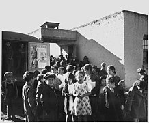 School children in Llano, 1940s
 -
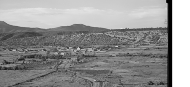 The hamlet of Rodarte, New Mexico, one mile from Llano, August 1940.


References[edit]
- ^ United States Postal Service. "USPS - Look Up a ZIP Code". Retrieved November 29, 2014.
- ^ "Llano". Geographic Names Information System. United States Geological Survey, United States Department of the Interior.
- ^ Julyan, Robert (1996). The Place Names of New Mexico. University of New Mexico Press. p. 205. ISBN 0826316891.
Municipalities and communities of Taos County, New Mexico, United States | ||
|---|---|---|
| Towns |  | |
| Villages | ||
| CDPs | ||
| Other communities | ||
| Ghost towns | ||
| Indian reservation | ||
| Footnotes | ‡This populated place also has portions in an adjacent county or counties | |