| In-SHUCK-ch Mountain | |
|---|---|
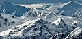
 North aspect, from Mt. Taylor | |
| Highest point | |
| Elevation | 2,386 m (7,828 ft)[1][2] |
| Prominence | 486 m (1,594 ft)[1] |
| Parent peak | Wedge Mountain[2] |
| Isolation | 8.27 km (5.14 mi)[1] |
| Listing | Mountains of British Columbia |
| Coordinates | 50°06′59″N 122°35′37″W / 50.11639°N 122.59361°W[3] |
| Geography | |
 In-SHUCK-ch Mountain Location in British Columbia  In-SHUCK-ch Mountain In-SHUCK-ch Mountain (Canada) | |
| Country | Canada |
| Province | British Columbia |
| District | New Westminster Land District[4] |
| Protected area | Garibaldi Provincial Park |
| Parent range | Coast Mountains[1] |
| Topo map | NTS 92J2 Whistler |
| Climbing | |
| First ascent | 1967 John Clarke[5] |
In-SHUCK-ch Mountain is a 2,386-metre (7,828-foot) summit in British Columbia, Canada.
Description[edit]
In-SHUCK-ch Mountain is located 26 kilometres (16 mi) east of Whistler in Garibaldi Provincial Park and the Coast Mountains.[1][4] Precipitation runoff and glacial meltwater from this mountain drains into tributaries of the Lillooet River. In-SHUCK-ch Mountain is more notable for its steep rise above local terrain than for its absolute elevation as topographic relief is significant with the summit rising 2,186 metres (7,172 ft) above Little Lillooet Lake in four kilometres (2.5 mi).
History[edit]
The mountain was officially named Gunsight Peak in 1978, but officially changed on August 13, 1992, by the Geographical Names Board of Canada.[3] The name of the mountain is pronounced In-SHUCK-ch, meaning "split like a crutch", which refers to the split gap of the summit area. The people of the In-SHUCK-ch Nation took their name from this sacred mountain.[6] In-SHUCK-ch Mountain is significant in the origin stories of the people, as the mountain provided a refuge from a great flood.[3]
Climate[edit]
Based on the Köppen climate classification, In-SHUCK-ch Mountain is located in the marine west coast climate zone of western North America.[7] Most weather fronts originate in the Pacific Ocean, and travel east toward the Coast Mountains where they are forced upward by the range (orographic lift), causing them to drop their moisture in the form of rain or snowfall. As a result, the Coast Mountains experience high precipitation, especially during the winter months in the form of snowfall. Winter temperatures can drop below −20 °C with wind chill factors below −30 °C. This climate supports an unnamed glacier on the north slope of the peak. The months of July and August offer the most favorable weather for climbing or viewing In-SHUCK-ch Mountain.
See also[edit]
Gallery[edit]
-
 In-SHUCK-ch Mountain in front.
Nivalis Mountain centered at top, Mount Sir Richard at far right. -
 Nivalis Mountain (upper left corner) and Mount Sir Richard (upper right corner) with the Southwest peak of In-shuck-ch Mountain centered.


References[edit]
- ^ a b c d e "In-shuck-ch Mountain, British Columbia". Peakbagger.com. Retrieved 2024-03-05.
- ^ a b "In-SHUCK-ch Mountain, Peakvisor.com". Retrieved 2024-03-05.
- ^ a b c "In-SHUCK-ch Mountain". BC Geographical Names.
- ^ a b "In-SHUCK-ch Mountain". Geographical Names Data Base. Natural Resources Canada. Retrieved 2024-03-05.
- ^ Climbers You Should Know About: John Clarke, Gripped, January 26, 2021. Retrieved 2024-03-05.
- ^ William C. Sturtevant, Handbook of North American Indians: Plateau, 1998, Smithsonian Institution, ISBN 9780140495140, p. 189.
- ^ Peel, M. C.; Finlayson, B. L.; McMahon, T. A. (2007). "Updated world map of the Köppen−Geiger climate classification". Hydrol. Earth Syst. Sci. 11 (5): 1633. Bibcode:2007HESS...11.1633P. doi:10.5194/hess-11-1633-2007. ISSN 1027-5606.
External links[edit]
- Weather: In-SHUCK-ch Mountain
- In-SHUCK-ch Mountain (photo): Flickr
Places adjacent to In-SHUCK-ch Mountain | ||||||||||||||||
|---|---|---|---|---|---|---|---|---|---|---|---|---|---|---|---|---|
| ||||||||||||||||