No higher resolution available.
Rim_Village_map,_Comfort_Station_-4.JPG (520 × 281 pixels, file size: 54 KB, MIME type: image/jpeg)
Summary
| Description |
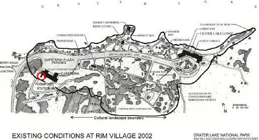
English: Rim Village (Crater Lake National Park) map showing location of Comfort Station #4; building is listed on National Register of Historic Places as "Comfort Station No. 72" (NRHP #88002625) |
| Date | |
| Source | http://www.craterlakeinstitute.com/online-library/rim-village-cli/site.htm |
| Author | National Park Service |
| Permission (Reusing this file) |
Public Domain |
| Other versions | Original version does not red circle |
Licensing
| This image or media file contains material based on a work of a National Park Service employee, created as part of that person's official duties. As a work of the U.S. federal government, such work is in the public domain in the United States. See the NPS website and NPS copyright policy for more information. |
File history
Click on a date/time to view the file as it appeared at that time.
| Date/Time | Thumbnail | Dimensions | User | Comment | |
|---|---|---|---|---|---|
| current | 21:31, 15 July 2016 | | 520 × 281 (54 KB) | Sunmist | Border removed. |
| 23:57, 5 April 2008 |  | 561 × 309 (41 KB) | Orygun | {{Information |Description=Rim Village map showing location of Comfort Station #4; building is listed on National Register of Historic Places as "Comfort Station No. 72" (NRHP #88002625) |Source=http://www.craterlakeinstitute.com/online-library/rim-villag |
File usage
The following pages on the English Wikipedia use this file (pages on other projects are not listed):