Size of this preview: 776 × 600 pixels. Other resolutions: 311 × 240 pixels | 621 × 480 pixels | 994 × 768 pixels | 1,100 × 850 pixels.
Original file (1,100 × 850 pixels, file size: 811 KB, MIME type: image/jpeg)

|
This geology image could be re-created using vector graphics as an SVG file. This has several advantages; see Commons:Media for cleanup for more information. If an SVG form of this image is available, please upload it and afterwards replace this template with
{{vector version available|new image name}}.
It is recommended to name the SVG file “Oregon wind resource map 50m 800.svg”—then the template Vector version available (or Vva) does not need the new image name parameter. |
Summary
| Description |
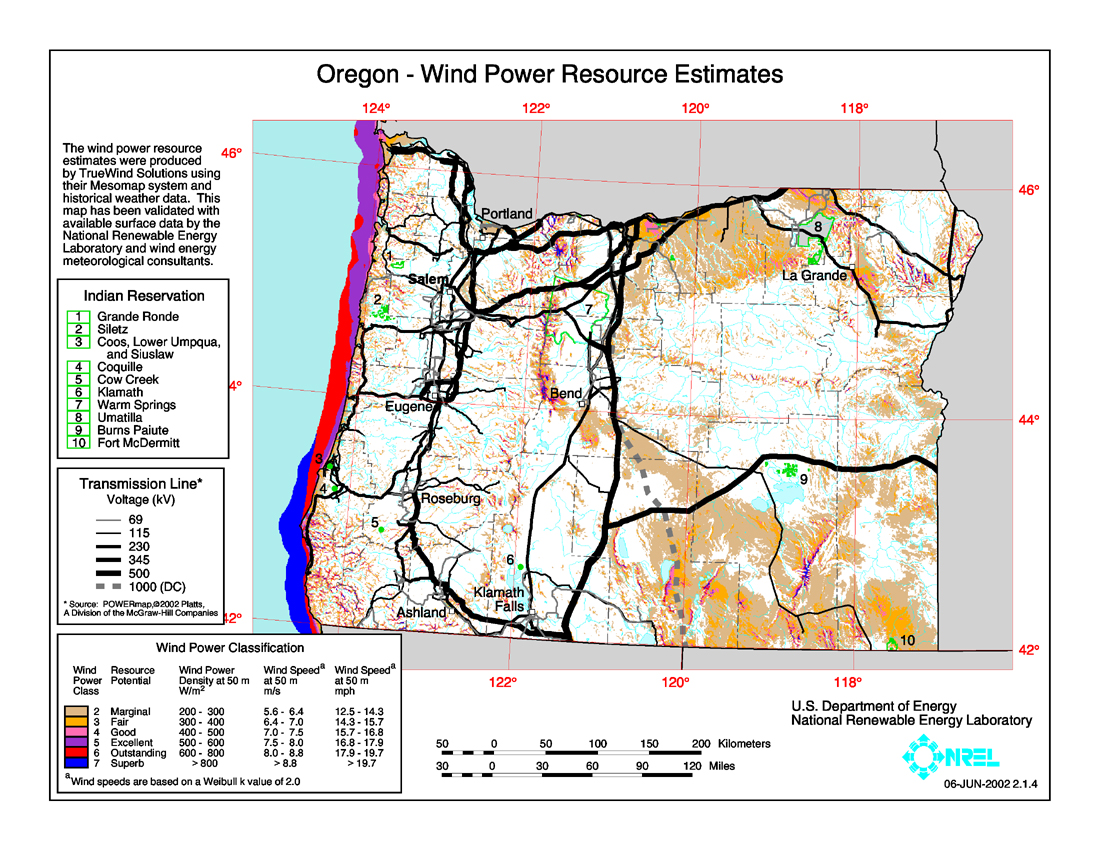
English: Average annual wind power distribution for Oregon, 50m height above ground, also showing location of existing electrical transmission lines |
| Date | |
| Source | http://www.windpoweringamerica.gov/images/windmaps/or_50m_800.jpg |
| Author | United States Department of Energy, National Renewable Energy Laboratory, TrueWind Solutions |
| Permission (Reusing this file) |
EERE copyright policy says its works are public domain: http://www1.eere.energy.gov/webpolicies/#copyright |
| Other versions | http://www.awstruewind.com/files/OR_pwr50m.pdf - more detailed commercial version |
Licensing
| This image is a work of a United States Department of Energy (or predecessor organization) employee, taken or made as part of that person's official duties. As a work of the U.S. federal government, the image is in the public domain.
Please note that national laboratories operate under varying licences and some are not free. Check the site policies of any national lab before crediting it with this tag.
|

|
File history
Click on a date/time to view the file as it appeared at that time.
| Date/Time | Thumbnail | Dimensions | User | Comment | |
|---|---|---|---|---|---|
| current | 08:14, 26 January 2009 | | 1,100 × 850 (811 KB) | Teratornis | == Summary == {{Information |Description={{en|1=Average annual wind power distribution for Oregon, 50m height above ground, also showing location of existing electrical transmission lines}} |Source=http://www.windpoweringamerica.gov/images/windmaps/or_50m |
File usage
The following pages on the English Wikipedia use this file (pages on other projects are not listed):