
Size of this preview: 800 × 532 pixels. Other resolutions: 320 × 213 pixels | 640 × 426 pixels | 1,024 × 681 pixels | 1,280 × 851 pixels | 2,560 × 1,702 pixels | 6,016 × 4,000 pixels.
Original file (6,016 × 4,000 pixels, file size: 6.47 MB, MIME type: image/jpeg)
| Camera location | | View this and other nearby images on: OpenStreetMap |
|---|
| Description |
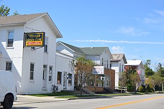
English: Buildings on the southern side of Main Street (U.S. Route 35) west of Church Street in central New Lebanon, Ohio, United States. |
||
| Date | Taken on 13 September 2016 | ||
| Source | Own work | ||
| Author | Nyttend | ||
| Permission (Reusing this file) |
|
File history
Click on a date/time to view the file as it appeared at that time.
| Date/Time | Thumbnail | Dimensions | User | Comment | |
|---|---|---|---|---|---|
| current | 03:09, 20 September 2016 | | 6,016 × 4,000 (6.47 MB) | Nyttend | {{Location|39|44|44|N|84|23|10|W}} {{Information |Description={{en|Buildings on the southern side of Main Street ({{w|U.S. Route 35}}) west of Church Street in central {{w|New Lebanon, Ohio|New Lebanon}}, {{w|Ohio}}, {{w|United States}}.}} |Source={{Ow... |
File usage
The following pages on the English Wikipedia use this file (pages on other projects are not listed):
Global file usage
The following other wikis use this file:
- Usage on ar.wikipedia.org
- Usage on arz.wikipedia.org
- Usage on ca.wikipedia.org
- Usage on ceb.wikipedia.org
- Usage on cy.wikipedia.org
- Usage on es.wikipedia.org
- Usage on eu.wikipedia.org
- Usage on fr.wikipedia.org
- Usage on ht.wikipedia.org
- Usage on it.wikipedia.org
- Usage on lld.wikipedia.org
- Usage on pl.wikipedia.org
- Usage on pt.wikipedia.org
- Usage on sr.wikipedia.org
- Usage on uk.wikipedia.org
- Usage on ur.wikipedia.org
- Usage on vi.wikipedia.org
- Usage on www.wikidata.org
- Usage on zh-min-nan.wikipedia.org