
Size of this preview: 800 × 600 pixels. Other resolutions: 320 × 240 pixels | 640 × 480 pixels | 1,024 × 768 pixels | 1,280 × 960 pixels | 2,560 × 1,920 pixels | 8,000 × 6,000 pixels.
Original file (8,000 × 6,000 pixels, file size: 11.59 MB, MIME type: image/png)
Summary
| Description |
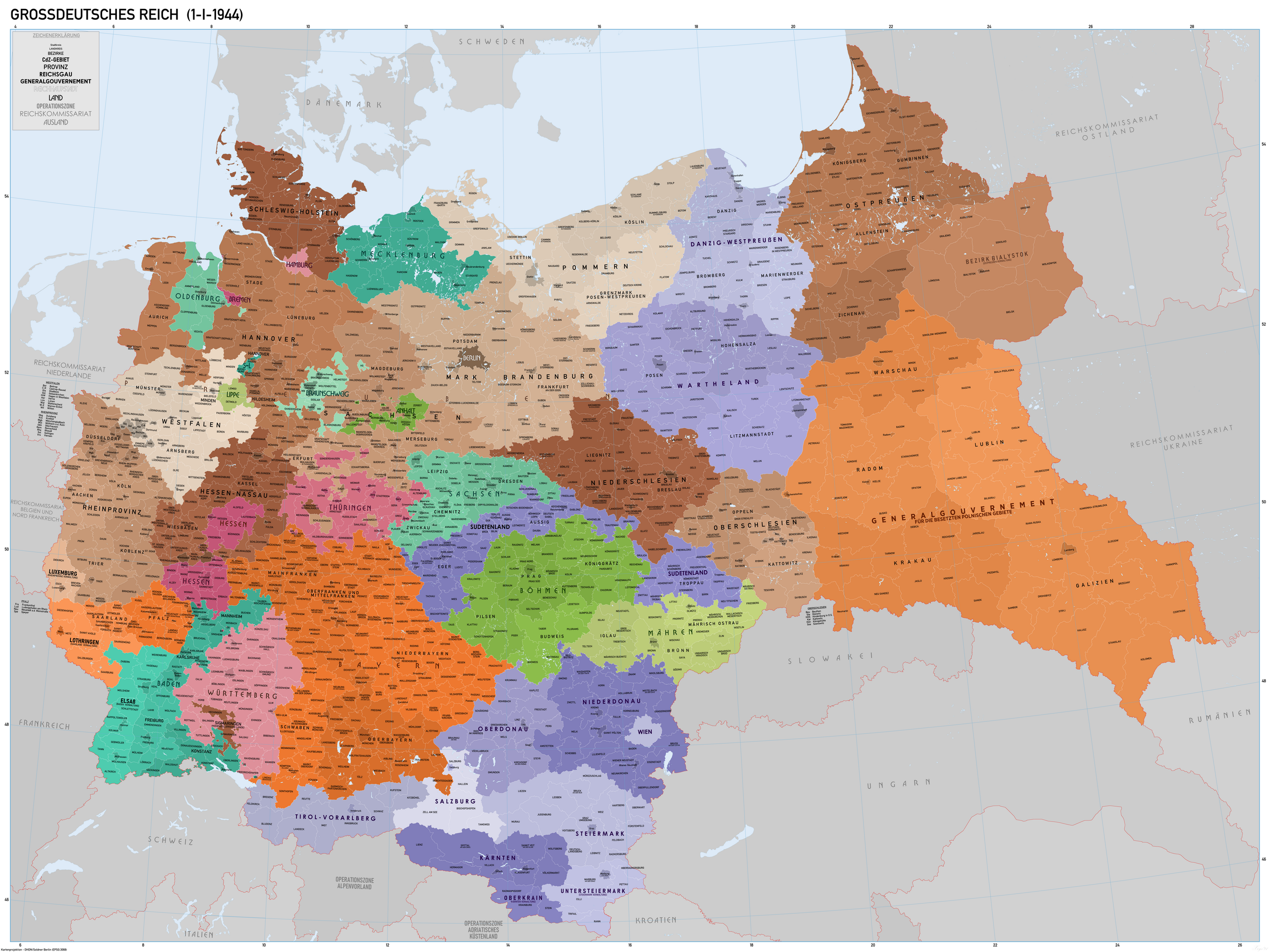
Deutsch: Verwaltungskarte des Grossdeutschen Reiches, im 1-1-1944. Quelle GIS Data digitisierte aus Karte des Deutschen Reiches 1:100 000 und Karte von Mitteleuropa 1:300k. Etwa Karte Quellen bei WIG (www.mapywig.org). Verwaltungsdatei bei http://territorial.de/. |
| Date | |
| Source | Own work |
| Author | XrysD |
| Other versions |
 |
Licensing
I, the copyright holder of this work, hereby publish it under the following license:
This file is licensed under the Creative Commons Attribution-Share Alike 4.0 International license.
- You are free:
- to share – to copy, distribute and transmit the work
- to remix – to adapt the work
- Under the following conditions:
- attribution – You must give appropriate credit, provide a link to the license, and indicate if changes were made. You may do so in any reasonable manner, but not in any way that suggests the licensor endorses you or your use.
- share alike – If you remix, transform, or build upon the material, you must distribute your contributions under the same or compatible license as the original.
File history
Click on a date/time to view the file as it appeared at that time.
| Date/Time | Thumbnail | Dimensions | User | Comment | |
|---|---|---|---|---|---|
| current | 10:30, 17 October 2021 | | 8,000 × 6,000 (11.59 MB) | XrysD | Incorporated typos KRUBIESZOW->HRUBIESZOW and CZORTZOW->CZORTKOW and removed duplicate of Gumpolds in Boh-Mar. Reverted Lublin district border changes, see https://commons.wikimedia.org/wiki/User_talk:Kamilhrub |
| 22:46, 10 October 2021 |  | 8,000 × 6,000 (13.64 MB) | Kamilhrub | Corrected name Hrubieszow and southern borders of Bilgoraj, Hrubieszow and Zamosc districts, which didn't change after 1941 (source: Amtliches Gemeinde- und Dorfverzeichnis für das Generalgouvernement auf Grund der Summarischen Bevölkerungsbestandsaufnahme am 1. März 1943) | |
| 17:39, 21 January 2020 |  | 8,000 × 6,000 (11.59 MB) | XrysD | Tippfehler: Güding-->Göding | |
| 19:25, 16 December 2019 |  | 8,000 × 6,000 (11.59 MB) | XrysD | Noch zwei Schreibfehler korrigiert: Königgratz -> Königgrätz Koniginhof -> Königinhof | |
| 15:22, 27 November 2019 |  | 8,000 × 6,000 (11.59 MB) | XrysD | Drei Schreibfehler korrigiert. Württemburg -> Württemberg (Hohenzollerisch Lande) -> (Hohenzollernsche Lande) Operationszone Adriatisches Kustenland -> Operationszone Adriatisches Küstenland | |
| 12:12, 23 November 2019 |  | 8,000 × 6,000 (11.59 MB) | XrysD | User created page with UploadWizard |
File usage
The following pages on the English Wikipedia use this file (pages on other projects are not listed):
Global file usage
The following other wikis use this file:
- Usage on ar.wikipedia.org
- Usage on de.wikipedia.org
- Usage on ko.wikipedia.org
- Usage on ku.wikipedia.org
- Usage on pt.wikipedia.org
- Usage on ru.wikipedia.org
- Usage on uk.wikipedia.org
- Usage on uz.wikipedia.org
- Usage on vi.wikipedia.org