
Size of this PNG preview of this SVG file: 800 × 443 pixels. Other resolutions: 320 × 177 pixels | 640 × 355 pixels | 1,024 × 568 pixels | 1,280 × 709 pixels | 2,560 × 1,419 pixels | 1,281 × 710 pixels.
Original file (SVG file, nominally 1,281 × 710 pixels, file size: 41 KB)
Summary
| Description |
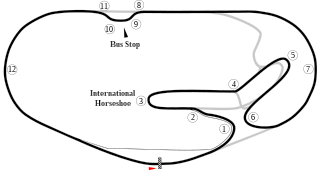
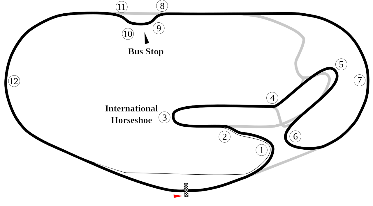
English: Track map of Daytona International Speedway showing mainly the road course. |
| Date | 7-8-2008 |
| Source | Own work |
| Author | Will Pittenger |
| Other versions |
|


| Camera location | | View this and other nearby images on: OpenStreetMap |
|---|
Licensing
| I, the copyright holder of this work, release this work into the public domain. This applies worldwide. In some countries this may not be legally possible; if so: I grant anyone the right to use this work for any purpose, without any conditions, unless such conditions are required by law. |
File history
Click on a date/time to view the file as it appeared at that time.
| Date/Time | Thumbnail | Dimensions | User | Comment | |
|---|---|---|---|---|---|
| current | 23:45, 28 January 2012 | | 1,281 × 710 (41 KB) | Spyder Monkey | new bus stop route |
| 22:44, 25 October 2009 |  | 1,354 × 687 (42 KB) | Spyder Monkey | ... | |
| 22:42, 25 October 2009 |  | 1,354 × 687 (42 KB) | Spyder Monkey | added missing part of oval between 1-6, attempting to fix cropping issue... | |
| 02:37, 16 October 2009 |  | 1,354 × 687 (42 KB) | Spyder Monkey | resize | |
| 02:35, 16 October 2009 |  | 1,281 × 710 (41 KB) | Spyder Monkey | Corrected bus stop route & corner numbers | |
| 10:16, 8 July 2008 |  | 1,281 × 710 (46 KB) | Will Pittenger | {{Information |Description={{en|1=Track map of w:Daytona International Speedway showing mainly the road course.}} |Source=Own work by uploader |Author=Will Pittenger |Date=7-8-2008 |Permission= |other_versions=[[Image:Daytona |
File usage
The following pages on the English Wikipedia use this file (pages on other projects are not listed):
- 1985 24 Hours of Daytona
- 1986 24 Hours of Daytona
- 1987 24 Hours of Daytona
- 1988 24 Hours of Daytona
- 1989 24 Hours of Daytona
- 1990 24 Hours of Daytona
- 1991 24 Hours of Daytona
- 1992 24 Hours of Daytona
- 1993 24 Hours of Daytona
- 1994 24 Hours of Daytona
- 1995 24 Hours of Daytona
- 1996 24 Hours of Daytona
- 1997 24 Hours of Daytona
- 1998 24 Hours of Daytona
- 1999 24 Hours of Daytona
- 2000 24 Hours of Daytona
- 2001 24 Hours of Daytona
- 2002 24 Hours of Daytona
- 2003 24 Hours of Daytona
- 2004 24 Hours of Daytona
- 2005 24 Hours of Daytona
- 2006 24 Hours of Daytona
- 2007 24 Hours of Daytona
- 2008 24 Hours of Daytona
- 2009 24 Hours of Daytona
- 2009 Brumos Porsche 250
- 2010 24 Hours of Daytona
- 2011 24 Hours of Daytona
- 2012 24 Hours of Daytona
- 2013 24 Hours of Daytona
- 2014 24 Hours of Daytona
- 2015 24 Hours of Daytona
- 2016 24 Hours of Daytona
- 2016 Finali Mondiali
- 2017 24 Hours of Daytona
- 2018 24 Hours of Daytona
- 2019 24 Hours of Daytona
- 2020 24 Hours of Daytona
- 2020 WeatherTech 240
- 2021 24 Hours of Daytona
- 2022 24 Hours of Daytona
- 2023 24 Hours of Daytona
- 2024 24 Hours of Daytona
- 2024 IMSA VP Challenge Round at Daytona International Speedway
- 24 Hours of Daytona
- Daytona 200
- Daytona International Speedway
- List of AMA Superbike Championship circuits
- List of Grand Prix motorcycle circuits
- List of IMSA GT Championship circuits
- List of IMSA SportsCar Championship circuits
- List of World Sportscar Championship circuits
- Oval track racing
- WeatherTech 240
- User:SmackJam/sandbox/2020 Cadillac DPi Clash
Global file usage
The following other wikis use this file:
- Usage on de.wikipedia.org
- 24-Stunden-Rennen von Daytona
- 24-Stunden-Rennen von Daytona 1981
- 24-Stunden-Rennen von Daytona 1967
- 24-Stunden-Rennen von Daytona 1966
- 24-Stunden-Rennen von Daytona 2018
- 24-Stunden-Rennen von Daytona 1983
- 24-Stunden-Rennen von Daytona 1982
- 24-Stunden-Rennen von Daytona 1980
- 24-Stunden-Rennen von Daytona 1979
- 24-Stunden-Rennen von Daytona 1978
- 24-Stunden-Rennen von Daytona 1977
- 24-Stunden-Rennen von Daytona 1976
- 24-Stunden-Rennen von Daytona 1975
- 24-Stunden-Rennen von Daytona 1973
- 6-Stunden-Rennen von Daytona 1980
- Kategorie:Daytona International Speedway
- Usage on es.wikipedia.org
- Usage on eu.wikipedia.org
- Usage on fa.wikipedia.org
- Usage on fi.wikipedia.org
- Usage on fr.wikipedia.org
- Usage on he.wikipedia.org
- Usage on hr.wikipedia.org
- Usage on id.wikipedia.org
- Usage on it.wikipedia.org
- Usage on ja.wikipedia.org
- Usage on nl.wikipedia.org
View more global usage of this file.