No higher resolution available.
Chesapeake_Bay_Watershed.png (300 × 345 pixels, file size: 16 KB, MIME type: image/png)
Summary
| Description |
Български: Местообитанието на Часи.
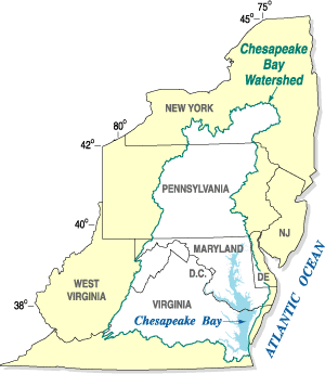
Dansk: Vandskellet omkring Chesapeake Bay.
English: The Chesapeake Bay Watershed.
Español: Mapa de la cuenca hidrográfica de la bahía de Chesapeake (en blanco), mostrando los estados a los que drena.
Nederlands: Chesapeake Bay stroomgebied. English: Chesapeake Bay Watershed overlaid on political map of Mid-Atlantic states It is a large body of water |
| Source | United States Geological Survey |
| Author |
Licensing
This work is in the public domain in the United States because it is a work prepared by an officer or employee of the United States Government as part of that person’s official duties under the terms of Title 17, Chapter 1, Section 105 of the US Code.
Note: This only applies to original works of the Federal Government and not to the work of any individual U.S. state, territory, commonwealth, county, municipality, or any other subdivision. This template also does not apply to postage stamp designs published by the United States Postal Service since 1978. (See § 313.6(C)(1) of Compendium of U.S. Copyright Office Practices). It also does not apply to certain US coins; see The US Mint Terms of Use.
|
 | |
| This file has been identified as being free of known restrictions under copyright law, including all related and neighboring rights. | ||
Original upload log
Transferred from en.wikipedia to Commons by Hejsa.
The original description page was here. All following user names refer to en.wikipedia.
- 2008-01-31 01:59 Karma Heretic 300×345× (13443 bytes) {{Information |Description=Chesapeake Bay Watershed overlaid on political map of Mid-Atlantic states |Source=United States Geological Survey |Date=January 30, 2008 |Location=http://md.water.usgs.gov/publications/fs-091-03/html/location_big.gif |Author= |P
Original upload log
| Date/Time | Dimensions | User | Comment |
|---|---|---|---|
| 7 November 2008, 15:29:53 | 300 × 345 (13443 bytes) | Hejsa (talk · contribs) | {{Information |Description={{en|Chesapeake Bay Watershed overlaid on political map of Mid-Atlantic states<br/> It is a large body of water}} |Source=Transferred from [http://en.wikipedia.org en.wikipedia]; transfer was stated to be made by [[User:Hejsa]]. |
File history
Click on a date/time to view the file as it appeared at that time.
| Date/Time | Thumbnail | Dimensions | User | Comment | |
|---|---|---|---|---|---|
| current | 15:29, 21 November 2014 | | 300 × 345 (16 KB) | GifTagger | Bot: Converting file to superior PNG file. (Source: Chesapeake_Bay_Watershed.gif). This GIF was problematic due to transparency and non-greyscale color table. |
File usage
The following pages on the English Wikipedia use this file (pages on other projects are not listed):
Global file usage
The following other wikis use this file:
- Usage on bg.wikipedia.org
- Usage on da.wikipedia.org
- Usage on es.wikipedia.org
- Usage on fy.wikipedia.org
- Usage on nl.wikipedia.org
- Usage on th.wikipedia.org