
Size of this preview: 800 × 600 pixels. Other resolutions: 320 × 240 pixels | 640 × 480 pixels | 1,024 × 768 pixels | 1,280 × 960 pixels | 2,560 × 1,920 pixels | 4,000 × 3,000 pixels.
Original file (4,000 × 3,000 pixels, file size: 8.51 MB, MIME type: image/jpeg)
Summary
| Description |
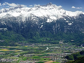
English: The Chablais region around Monthey (far right), viewed from above Torgon. The Rhone marks the border between the Vaud (background) and Valais (foreground) parts of the Chablais. The region is overlooked by the massif of the Dent de Morcles. On the bottom left is the Collombey refinery complex. Note the snow and foliation limit of deciduous trees at about 1,000 metres above sea level and in the middle of the image (all elevations are from Swisstopo). |
| Date | |
| Source | Own work |
| Author | Zacharie Grossen |
| Camera location | | View this and other nearby images on: OpenStreetMap |
|---|
Licensing
I, the copyright holder of this work, hereby publish it under the following license:
This file is licensed under the Creative Commons Attribution-Share Alike 4.0 International license.
- You are free:
- to share – to copy, distribute and transmit the work
- to remix – to adapt the work
- Under the following conditions:
- attribution – You must give appropriate credit, provide a link to the license, and indicate if changes were made. You may do so in any reasonable manner, but not in any way that suggests the licensor endorses you or your use.
- share alike – If you remix, transform, or build upon the material, you must distribute your contributions under the same or compatible license as the original.
| Annotations | This image is annotated: View the annotations at Commons |
File history
Click on a date/time to view the file as it appeared at that time.
| Date/Time | Thumbnail | Dimensions | User | Comment | |
|---|---|---|---|---|---|
| current | 12:22, 4 July 2018 | | 4,000 × 3,000 (8.51 MB) | Zacharie Grossen | luminosity and colors |
| 14:19, 30 July 2016 |  | 4,000 × 3,000 (7.44 MB) | Zacharie Grossen | uploading new image (older one was moved to File:Chablais Alps.jpg) | |
| 14:17, 30 July 2016 |  | 4,000 × 3,000 (7.44 MB) | Zacharie Grossen |
File usage
The following pages on the English Wikipedia use this file (pages on other projects are not listed):
Global file usage
The following other wikis use this file:
- Usage on arz.wikipedia.org
- Usage on bg.wikipedia.org
- Usage on de.wikipedia.org
- Usage on es.wikipedia.org
- Usage on fr.wikipedia.org
- Usage on oc.wikipedia.org
- Usage on sr.wikipedia.org
- Usage on tr.wikipedia.org