
Size of this preview: 800 × 322 pixels. Other resolutions: 320 × 129 pixels | 640 × 257 pixels | 1,024 × 412 pixels | 1,280 × 514 pixels | 3,200 × 1,286 pixels.
Original file (3,200 × 1,286 pixels, file size: 1.53 MB, MIME type: image/jpeg)
Summary
| Description |
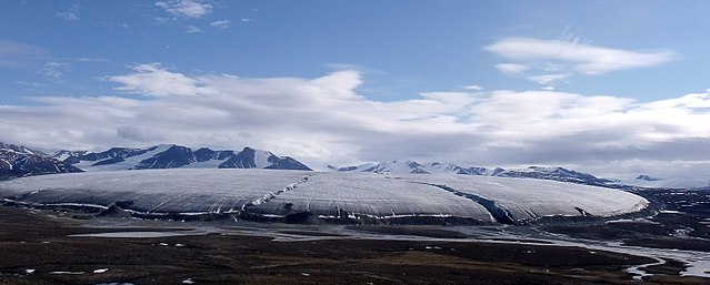
A much larger mothership than before. This mountain glacier is one of many streams of ice coming down from the interior ice cap on top of Byam Martin Mtns. View large to see this 3 mile wide tongue's terminal moraine. Pond Inlet is the nearest community to Sirmilik National Park. For those folks looking for the most scenic places to visit in Canada's far north, I am one happy camper who will point you to landscape painter Cory Trepanier's video "Into the Arctic II". intothearctic.com/ Deutsch: Gletscher der Byam Martin Mountains auf der, der an seinem Rand eine Endmoräne aufschüttet. |
| Date | |
| Source | Bylot Island Glacier |
| Author | Mike Beauregard from Nunavut, Canada |
| Camera location | | View this and other nearby images on: OpenStreetMap |
|---|
Licensing
This file is licensed under the Creative Commons Attribution 2.0 Generic license.
- You are free:
- to share – to copy, distribute and transmit the work
- to remix – to adapt the work
- Under the following conditions:
- attribution – You must give appropriate credit, provide a link to the license, and indicate if changes were made. You may do so in any reasonable manner, but not in any way that suggests the licensor endorses you or your use.
| This image was originally posted to Flickr by subarcticmike at https://www.flickr.com/photos/31856336@N03/7722673784. It was reviewed on 10 October 2012 by FlickreviewR and was confirmed to be licensed under the terms of the cc-by-2.0. |

.jpg¶ms=073.211633_N_-079.826660_E_globe:Earth_type:camera_source:Flickr_&language=en)
File history
Click on a date/time to view the file as it appeared at that time.
| Date/Time | Thumbnail | Dimensions | User | Comment | |
|---|---|---|---|---|---|
| current | 15:03, 9 June 2014 | 3,200 × 1,286 (1.53 MB) | Tillman | Cropped version of File:Bylot Island Glacier.jpg using CropTool. |
File usage
The following pages on the English Wikipedia use this file (pages on other projects are not listed):
Global file usage
The following other wikis use this file:
- Usage on bs.wikipedia.org
- Usage on ca.wikipedia.org
- Usage on de.wikipedia.org
- Usage on es.wikipedia.org
- Usage on he.wikipedia.org
- Usage on ky.wikipedia.org
- Usage on pt.wikipedia.org
- Usage on sr.wikipedia.org
- Usage on uk.wikipedia.org
.jpg)