
Original file (1,776 × 2,502 pixels, file size: 7.43 MB, MIME type: image/png)
Summary
| Description |
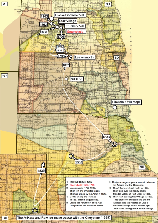
English: Map adapted to show the major movements (approximately) of the Arikara tribe from 1795 to 1862.
Source to archaelogical site 39ST50 and Greenshild.: Johnson, Craig M. (2007): A Chronology of Middle Missouri Plains Village Sites. Smithsonian contributions to Anthropology • number 47. Washington. P. 199 Sources to Delisle 1718 map, Leavenworth Site, the stay in present Nebraska and the peace council with the Cheyenne: Wood, Raymond W.: Historical and Archeological Evidence for Arikara Visits to the Central Plains. Plains Anthropologist. 1955 (July), No. 4, pp. 27-39. Meyer, Roy W. (1977): The Village Indians of the Upper Missouri. Lincoln and London. Pp. 87-89. Source to the Mandan village at Fort Clark, Star Village and Like-a-Fishhook Village: Meyer, Roy W. (1977): The Village Indians of the Upper Missouri. Lincoln and London. Pp. 90 and 108 |
| Date | |
| Source | 18th Annual Report of the Bureau of American Ethnology, 1896-'97. Part II, Smithsonian Institution. Washington 1899. GPO |
| Author | Unknown author |
North America, US, North Dakota, South Dakota, Nebraska, Colorado
Licensing
This work is in the public domain in the United States because it was published (or registered with the U.S. Copyright Office) before January 1, 1929.
Public domain works must be out of copyright in both the United States and in the source country of the work in order to be hosted on the Commons. If the work is not a U.S. work, the file must have an additional copyright tag indicating the copyright status in the source country.
Note: This tag should not be used for sound recordings. |
File history
Click on a date/time to view the file as it appeared at that time.
| Date/Time | Thumbnail | Dimensions | User | Comment | |
|---|---|---|---|---|---|
| current | 03:45, 8 July 2018 | | 1,776 × 2,502 (7.43 MB) | Naawada2016 | User created page with UploadWizard |
File usage
Global file usage
The following other wikis use this file:
- Usage on ru.wikipedia.org