Size of this preview: 775 × 600 pixels. Other resolutions: 310 × 240 pixels | 620 × 480 pixels | 814 × 630 pixels.
Original file (814 × 630 pixels, file size: 102 KB, MIME type: image/png)
Summary
| Description |
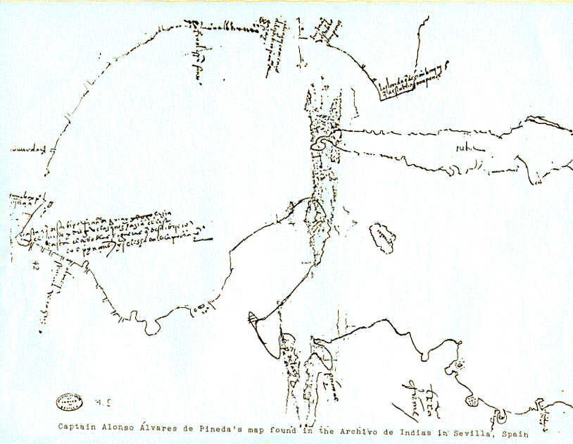
English: The map drawn by Alonso Alvarez de Pineda of the coast of the Gulf of Mexico in 1519. Русский: Карта Мексиканского залива, сделаннная Пинедой. Первая карта этого региона, сделанная европейцами |
| Date | |
| Source | Scan or photograph of 1519 map. Transferred from en.wikipedia to Commons. http://pares.mcu.es/ParesBusquedas/servlets/Control_servlet?accion=3&txt_id_desc_ud=20814&fromagenda=N |
| Author | Alonso Alvarez de Pineda |
Licensing
|
This work is in the public domain in its country of origin and other countries and areas where the copyright term is the author's life plus 100 years or fewer. | |
| This file has been identified as being free of known restrictions under copyright law, including all related and neighboring rights. | |
Original upload log
The original description page was here. All following user names refer to en.wikipedia.
- 2007-12-06 16:13 Karanacs 814×630× (68753 bytes) This is the map drawn by [[Alonso Alvarez de Pineda]] of the coast of the [[Gulf of Mexico]] in 1519.
Original upload log
| Date/Time | Dimensions | User | Comment |
|---|---|---|---|
| 28 June 2011, 21:20:39 | 814 × 630 (68753 bytes) | Urdangaray (talk · contribs) | {{Information |Description={{en|This is the map drawn by [[:en:Alonso Alvarez de Pineda|]] of the coast of the [[:en:Gulf of Mexico|]] in 1519.}} |Source=Transferred from [http://en.wikipedia.org en.wikipedia] |Date={{Date|2007|12|06}} (original upload da |
File history
Click on a date/time to view the file as it appeared at that time.
| Date/Time | Thumbnail | Dimensions | User | Comment | |
|---|---|---|---|---|---|
| current | 15:51, 14 August 2014 | | 814 × 630 (102 KB) | GifTagger | Bot: Converting file to superior PNG file. (Source: Alonso_Alvarez_de_Pineda_Map_of_Gulf_Coast.GIF). This GIF was problematic due to non-greyscale color table. |
File usage
The following pages on the English Wikipedia use this file (pages on other projects are not listed):
Global file usage
The following other wikis use this file:
- Usage on ca.wikipedia.org
- Usage on de.wikipedia.org
- Usage on es.wikipedia.org
- Usage on he.wikipedia.org
- Usage on it.wikipedia.org
- Usage on ru.wikipedia.org
- Usage on tr.wikipedia.org