
Size of this preview: 800 × 495 pixels. Other resolutions: 320 × 198 pixels | 640 × 396 pixels | 1,024 × 634 pixels | 1,280 × 792 pixels | 2,560 × 1,584 pixels | 12,635 × 7,817 pixels.
Original file (12,635 × 7,817 pixels, file size: 8.22 MB, MIME type: image/jpeg)
Summary
| Warning | The original file is very high-resolution. It might not load properly or could cause your browser to freeze when opened at full size. |
|---|
| Description |
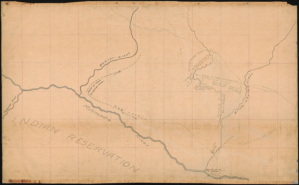
English: Detail plan shows wagons in half circle and posting of horses killed, with drawings of wagons, officers tents, and dugouts pasted on. Presumed to be prepared by Robert K. Boyd, a survivor of the battle. Pen-and-ink and some crayon and watercolor. Watermark: Dietzgen "Double Force" Germany. Ancillary map pasted on in upper right corner of detailed plan: Sectional map, U.S. Survey : [shows direct line distance of 14 miles between Fort Ridgley and the battle grounds]. Scale [ca. 1:63,360]. 1 in. = 1 mile. Available also through the Library of Congress Web site as a raster image. Gift; David W. Cook and Dorothy Wampole; 1994. Vault Filed with map: [Photocopy of author's] The Battle of Birch Coulee : a wounded man's description of a battle with the Indians, c1925. Acquisitions control no. 94-10 |
||
| Title | [Historical maps relating to the Battle of Birch Coulee, Minnesota 1862]. | ||
| Shelf ID | G4142.B53S4 19-- .B6 | ||
| Date | 19?? | ||
| Source | https://www.loc.gov/item/96687321/ | ||
| Author | Boyd, Robert K. | ||
| Permission (Reusing this file) |
|
||
| Other versions |
|
||
| Location | Renville County · Birch Coulee, Battle Of, Minn., 1862 · Birch Coulee, Battle Of, Minn., 1862. · Minnesota · United States · Renville County. | ||
| Part of | Military Battles And Campaigns · General Maps · Catalog · Geography And Map Division · American Memory | ||
| Subject | Maps, Manuscript · Renville County · Renville County (Minn.) · Minnesota · Birch Coulee, Battle Of, Minn. · United States · History |


Licensing
This work is in the public domain in the United States because it is a work prepared by an officer or employee of the United States Government as part of that person’s official duties under the terms of Title 17, Chapter 1, Section 105 of the US Code.
Note: This only applies to original works of the Federal Government and not to the work of any individual U.S. state, territory, commonwealth, county, municipality, or any other subdivision. This template also does not apply to postage stamp designs published by the United States Postal Service since 1978. (See § 313.6(C)(1) of Compendium of U.S. Copyright Office Practices). It also does not apply to certain US coins; see The US Mint Terms of Use.
|
 | |
| This file has been identified as being free of known restrictions under copyright law, including all related and neighboring rights. | ||
File history
Click on a date/time to view the file as it appeared at that time.
| Date/Time | Thumbnail | Dimensions | User | Comment | |
|---|---|---|---|---|---|
| current | 10:30, 14 October 2019 | | 12,635 × 7,817 (8.22 MB) | Fæ | LOC Maps https://www.loc.gov/item/96687321/ #21703 |
File usage
The following pages on the English Wikipedia use this file (pages on other projects are not listed):
._LOC_96687321.jpg)