Conyers Residential Historic District | |
   | |
| Location | NW of the central business district, roughly along Main St., Milstead Ave., and Railroad St., Conyers, Georgia |
|---|---|
| Coordinates | 33°40′15″N 84°1′13″W / 33.67083°N 84.02028°W |
| Area | 85 acres (34 ha) |
| Built | 1840 |
| Architect | Neel Reid, Willis F. Denny |
| Architectural style | Mid 19th Century Revival, Late 19th and 20th Century Revivals, Late Victorian |
| NRHP reference No. | 90000947[1] |
| Added to NRHP | July 5, 1990 |
-
 Craftsmen Bungalow within Conyers Commercial Historic District
 -
 College Ave that runs through Conyers Commercial Historic District.
 -
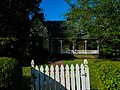 Almand-O'Kelley-Walker House - also on the National Register of Historical Places within Conyers Residential Historic District.


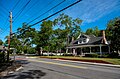
The Conyers Residential Historic District is an irregularly-shaped historic district in Conyers, Georgia, the only city in Rockdale County, Georgia, located 24 miles east of Atlanta. The district's development dates from the 1840s.[2]
It has examples of high style architecture, including the Pierce Home Place (c. 1840s) Greek Revival style, at 988 Milstead Avenue.[2]
Atlanta architect Neel Reid designed the Langford House (1913, see photo 1), at 900 Main Street, which has a mix of Classical Revival and Italian Renaissance styles. It has identical side porches and a front porch with a columned portico.[2]
Atlanta architect Willis Denny designed the Methodist church (1902, see photo 35), Late Gothic Revival, in red brick.[2]
The district has three other churches:
- Presbyterian Church (1918, see photo 35), Late Gothic Revival, with granite veneer,
- Macedonia Baptist Church (1925, see photo 26), Late Gothic Revival, with granite veneer, and
- Baptist Church (1938, see photo 9), has elements of Classical Revival, red brick, which has a columned portico main entrance.[2]
It was listed on the National Register of Historic Places in 1990.[1] It was deemed significant for its architecture and in the area of community planning and development, the latter "because it reflects how a small railroad town grew to accommodate not only the railroad but also the major roads leading to other nearby towns. It was this irregular growth, rather than a planned grid pattern, which became the core of this district. The district developed in a radiating pattern from the wedge-shaped central business district. Railroad, Main, and Milstead are the three main arteries where development occurred."[2]: 10
In 1990, the district included 120 contributing buildings, one other contributing structure, and 16 non-contributing buildings.[2]: 2
References[edit]
- ^ a b "National Register Information System". National Register of Historic Places. National Park Service. March 13, 2009.
- ^ a b c d e f g Lisa Raflo (May 11, 1990). "National Register of Historic Places Registration: Conyers Residential Historic District". National Park Service. Retrieved April 13, 2017. with 35 photos
| Topics | |
|---|---|
| Lists by state |
|
| Lists by insular areas | |
| Lists by associated state | |
| Other areas | |
| Related | |