islands nowhere near those places; othewise unnotable map of just Korea |
Good friend100 (talk | contribs) it clearly shows the two islands. The caption helps the reader find the two islets. I don't understand why you and Lactose delete everything you don't like |
||
| Line 271: | Line 271: | ||
Image:Liancourt-rocks distances.png|Distances. Liancourt Rocks are located at 37°14′N, 131°52′E and [[Ulleungdo]] appears at 37°30′N, 130°52′E, west of Liancourt Rocks. |
Image:Liancourt-rocks distances.png|Distances. Liancourt Rocks are located at 37°14′N, 131°52′E and [[Ulleungdo]] appears at 37°30′N, 130°52′E, west of Liancourt Rocks. |
||
Image:Part of Kaisei Nihon Yochi Rotei Zenzu.jpg|Kaisei Nihon Yochi Rotei Zenzu (part, 1775, Japan). Matsushima appears at 37°50′N, 131°40′E with Takeshima (aka. Isotakeshima) at around 37°80′N, 131°00′E. |
Image:Part of Kaisei Nihon Yochi Rotei Zenzu.jpg|Kaisei Nihon Yochi Rotei Zenzu (part, 1775, Japan). Matsushima appears at 37°50′N, 131°40′E with Takeshima (aka. Isotakeshima) at around 37°80′N, 131°00′E. |
||
Image:18thcenturydokdo.jpg|An 18th century map of Korea that shows two islands to the east of Korea in the approximate locations of Ulleungdo and Liancourt Rocks. |
|||
Image:DaehanJeondo.jpg| Daehan Jeondo (part, 1899, Korea) Showing Usando slightly northeast to [[Ulleungdo]], both drawn just west of 37°40′N, 130°30′E. (whole images[http://www.occidentalism.org/?p=670][http://ullungdo.com/map/image/12.jpg]) |
Image:DaehanJeondo.jpg| Daehan Jeondo (part, 1899, Korea) Showing Usando slightly northeast to [[Ulleungdo]], both drawn just west of 37°40′N, 130°30′E. (whole images[http://www.occidentalism.org/?p=670][http://ullungdo.com/map/image/12.jpg]) |
||
Image:1834-Ulleungdo-map.jpg|Cheonggudo (part, 1834, Korea) To scale map featuring Usan (于山), located in about 10 [[Li (unit)#Other Cultures|ri]] from Ulleungdo. ([http://www.occidentalism.org/?p=328 whole and enlarged images]) |
Image:1834-Ulleungdo-map.jpg|Cheonggudo (part, 1834, Korea) To scale map featuring Usan (于山), located in about 10 [[Li (unit)#Other Cultures|ri]] from Ulleungdo. ([http://www.occidentalism.org/?p=328 whole and enlarged images]) |
||
Revision as of 15:33, 22 June 2007
 | |
| Geography | |
|---|---|
| Location | Sea of Japan (East Sea) |
| Coordinates | 37°14′30″N 131°52′E / 37.24167°N 131.867°EInvalid arguments have been passed to the {{#coordinates:}} function 37°14′30″N 131°52′E / 37.24167°N 131.867°EInvalid arguments have been passed to the {{#coordinates:}} function |
| Administration | |
South Korea | |
Liancourt Rocks are a group of disputed islets in the Sea of Japan (East Sea); South Korea currently controls the islets (where they are known as Dokdo (Solitary islands)), but they also claimed by Japan (where they are known as Takeshima (Bamboo islands)).[1][2] The name "Liancourt Rocks" comes from the French whaling ship Liancourt which charted the islets in 1849. The Korean Central News Agency of North Korea refers to them as Tok Islet in its English-language articles and supports control of the islands by "the Korean nation".[3]
South Korea claims it as Korean territory from records that date back to the sixth century during the Unified Silla period and on the 1900 Korean Empire ordinance incorporating three islands into modern Ulleung County. Japanese claims come from seventeenth century records, as well as a "terra nullius" incorporation in 1905. Today, South Korea classifies the islets as a part of Ulleung County, North Gyeongsang Province, while Japan classifies them as part of Okinoshima, in Oki District, Shimane Prefecture.
Geography
 | |
| English name | |
|---|---|
| English | Liancourt Rocks |
| Japanese name | |
| Hepburn romanization | Takeshima |
| Kanji | 竹島 |
| Korean name | |
| Hangul | 독도 |
| Hanja | 獨島 |
| Revised Romanization | Dokdo |
| McCune-Reischauer | Tokto |
Liancourt Rocks are composed mainly of two islets, 150 meters apart[4] (Seodo and Dongdo in Korean, Nishi-jima and Higashi-jima in Japanese; both literally meaning western island 西島 and eastern island 東島, respectively). The western islet is the larger of the two islets. Altogether, there are about 90 islets and reefs,[5] volcanic rocks formed in the Cenozoic era.[6] A total of 37 of these islets are recognized as permanent land.[5] In 2006, a Korean geologist reported that both of these islets, especially, the eastern islet formed 4.5 million years ago and Ulleungdo formed 2 million years later are quickly eroding and weathering, and expected to sink in the sea before Japan sinks.[7]
The total area of the islets is about 187,450 square meters, with their highest point at 169 meters in the western islet. The western islet is about 88,640 square meters in area; the eastern islet about 73,300 square meters.[5] Liancourt Rocks are located at about 131°52′ East longitude and about 37°14′ North latitude.[5] The western islet is located at 37°14′31″N 131°51′55″E / 37.24194°N 131.86528°E and the eastern islet is located at 37°14′27″N 131°52′10″E / 37.24083°N 131.86944°E. The islets are 217 km from mainland Korea and 250 km from mainland Japan.[4] The nearest Korean territory (Ulleung-do) is 87 km away and can be visible on fair days;[8][4] the nearest Japanese territory (Oki Islands) is 157 km away.[5]
The western islet consists of a single peak and features many caves along the coastline. The cliffs of the eastern islet are about 10 to 20 meters high. There are two caves giving access to the sea, as well as a crater.[6]
Economy
Over 900 Korean citizens list the islets as their residence, while over 2,000 Japanese do the same. However, only two people, a married Korean couple, are actual permanent residents.[9]
Korean telecom service providers (namely SK Telecom, KTF, and LG Telecom) have also installed stations on Liancourt Rocks to cover the islets in the South Korean wireless telephone network. There is also regular ferry service from Ulleung-do.[10]
Although the islets themselves are barely habitable, the Exclusive Economic Zone surrounding them has rich fishing grounds and possible reserves of natural gas.[11] As of 2006, the expected reserves have not been found.[5] A wide variety of fish as well as seaweed, kelp, sea slugs, and clams are located around Liancourt Rocks.[6] Major fishery catches in the area are squid, Alaskan pollock, codfish, and octopus.[6][5] There are 102 species of seaweed, although many of these have no economic value.[5]
This area used to be one of the largest breeding grounds of sea lions (Zalophus californianus japonicus) and a good spot for hunting them and also a spot for obtaining abalone at the end of the Meiji period (1868-1912).[12] Until the 1950s, sea lions were observed on Liancourt Rocks by the voluntary guards.[13]
There are approximately 37 South Korean police that guard the islets, also there are Ministry of Maritime Affairs & Fisheries personnel, a married Korean couple (whose occupation is fishing), and three lighthouse keepers living on the islets in rotation. In the past, several fishermen also lived there temporarily.[14]
Tourism
Due to their status as a nature reserve, special permits are required for tourists seeking to land on the islets rather than just circling them.[14] There were 1,507 and 1,597 recorded tourists in 2003 and 2004 respectively.[14] Visitors generally come by boat from Ulleung-do.[5][14]
In 2005, the first wedding ceremony was held on Liancourt Rocks. The South Korean couple chose the location to protest against Japanese territorial claims.[15]
Climate
Due to its location and extremely small size, the Liancourt Rocks sometimes have harsh weather. At times, ships are unable to dock because of strong northwestern winds in winter.[4][6] The climate is warm and humid, and heavily influenced by warm sea currents. Precipitation is high throughout the year (annual average - 1324 mm), with occasional snowfall.[6] Fog is a common sight. In the summer, southernly winds dominate.[6] The water around the islets is about 10 degrees Celsius in spring, when the water is coolest. It warms to about 25 degrees Celsius in August.[6]
Ecology
Like Ulleung-do, the islets are volcanic rocks, with only a thin layer of soil and moss.[5] About 80 species of plants, over 22 species of birds, and 37 species of insects have been recorded on the islets, in addition to the local maritime life.[4] The islets are too small to have any significant amount of fresh water.
Since the early 1970s, trees and some types of flowers were planted along with the indigenous flora and fauna.[4] (Trees are required under international law for the islets to be recognized as natural islands rather than reefs.[14][6])
Liancourt was declared a "Natural Monument #336" by South Korea in the 1990s. While home to some birds, the islets mostly provide temporary refuge for birds migrating elsewhere. They serve as a home to fork-tailed petrel, streaked shearwater, and black-tailed gulls. The population of breeding birds counted on the rocks, however, has been declining in recent years.[6]
In 1999, the islets were designated a special environmental protected area by the South Korean government.[4] They predate any other Korean volcanic islands, including Ulleung-do.[6]
It was announced in 2005 that three new genera and five new species of bacteria had been identified by ROK scientists in the waters off Liancourt. The genera are Dokdonella koreensis, Dokdonia donghaenensis, and Donghae dokdoensis. The newly identified species are Virgilbacillus dokdoensis, Maribacter dokdoensis, Marimonas dokdoensis, Polaribacter dokdoensis, and Porphyrobacter dokdoensis.
Strategic location
The islets are of importance not only for economic reasons, but also for military reasons. They have occasionally served for military purpose, such as a temporary watchtower during the Russo-Japanese War. The South Korean government has built a radar station and helicopter landing pad on the islets, enabling it to track foreign naval forces. The 37 police on the islets serve as armed guards.[5]
History of the territorial dispute
Korea and Japan have a long, complex history of cultural exchange, war, and political rivalry (see: Korean-Japanese disputes). The islets are the last disputed territory between Korea and Japan following World War II.
South Korea bases its claim on records that date back to the sixth century, including the 1900 Korean Empire ordinance that officially incorporated the Liancourt rocks into the modern-day Ulleung County of the Gyeongsangbuk-do.[16]
North Korea publicly supports the control of the island by "the Korean nation".The Korean Central News Agency of North Korea refers to the Liancourt rocks as "Tok Islet" in English, and publicly supports the control of the island by "the Korean nation".[17] [18]
Japanese protests Korea's claim and administration of the Liancourt rocks.[19] [20] Japan bases its claim on historical records from the seventeenth century and the 1905 terra nullius incorporation. Japan designates the islets as a part of Okinoshima in the Oki District of Shimane Prefecture. [21]
The Three Kingdoms period
In 1145, Samguk Sagi (Chronicles of Three Kingdoms) recorded that the state of Usan (Usan-guk), an island kingdom located on Ulleung-do, was conquered and "re-integrated" into the Korean kingdom of Silla in 512. Samguk Sagi mentions that another name of Usan-state is Ulleung-do.[22]
Korea argues that the rocks was called Usan-do and was a part of Usan-guk, based on later Joseon dynasty records such as the Yeojiji and Man'gi yoram. A number of historians in Japan reject the theory that Dokdo was a part of Usan-guk, disputing the Korean interpretation of the Samguk Sagi.
The Joseon and Edo Period
Taejong-sillok (Annals for King Taejong) recorded that 60 people were living on Yusan-guk-do (流山國, Yusan-state-island) and in 1412, and 86 people living on Usan-do in 1417.[23]
The Sejong Sillok ("Chronicle of King Sejong", 1432) mentions Usan-do ,[24][25] but interpretation of the context is disputed. Korean scholars interpret the text as: "Usan-do (于山島) and Mulung-do (武陵島, a former name of Ulleungdo), located in the sea east of the Uljin Prefecture, are close enough to each other that in clear weather the two islands come into view [of each other]", and consider it as evidence that Usan-do refers to the Liancourt Rocks, the only island that is visible from Ulleungdo only in clear weather.[25] Japanese scholars interpret the latter part as "come into view [from mainland Korea]" in the context of the whole text.[citation needed] Some others argue that Usan-do refers to Juk-do locating 4 km east of Ulleungdo. (The Chinese characters 竹島 are read as Juk-do in Korean and Takeshima in Japanese.)
The Don'guk yeoji seungnam ("Augmented Survey of the Geography of the Eastern Nation (Korea)", 1481) defining Korea's territory, stated that "Usando and Ulleungdo are under the jurisdiction of Uljin-hyeon of Gangwon-do as an administrative unit. However, Don'guk yoji sungnam also mentions that the tree and the beach could be clearly seen on a fine day and thus there is another theory that Usan-do and Ulleung-do are the same island, as trees cannot grow on Liancourt Rocks and the two islands are 90 km apart. Moreover, Korea interpreted the same record as the record that saw Ulleungdo from the peninsula in 1694 when the dispute of possession of Ulleungdo was occurred with Japan.[26] The 1531 revision of this book includes the Paldo Chongdo ("Map of the Eight Provinces"), showing two separate islands of Usan-do and Ulleung-do in the middle of the Sea of Japan (East Sea). Usando is drawn to the west of Ulleungdo (The Liancourt rock is to the east of Ulleungdo).
Man'gi yoram ("Handbook of State Affairs") from 1808 quotes the earlier Yeojiji ("Gazette") that Ulleungdo and Usando all belonged to Usan'guk and Usando is what Japanese call Matsushima, i.e., present Liancourt Rocks. [27]
On the Korean cartographs Donguk jido (by Chong Sang-gi, 1678~1752), Haejwa Jeondo (1822), and Dongguk Jeondo (by Kim Tae-gon, 1821~1846), Usando is displayed. From the Korean point of view, this islet is Liancourt Rocks, but Japan construes this to be Jukdo from the distance, shape, size, and direction.[28]
From the early fifteenth century to the aftermath of the Japanese invasions of Korea (1592-1598), the government in Korea was unable and unwilling to maintain a civilian population on both Ulleung-do and Usan-do. According to the Taejong Sillok ("Chronicle of King Taejong"), the mainland government forcibly evacuated the islands during his reign as according to the "vacant island policy"[29] and thus the islets was only occasionally populated by permanent settlers up to the seventeenth century (a permanent population existed only on Ulleung-do). Following the war, the islands were completely vacated.
Takeshima Tōkai Yuraiki Bassho Hikae, written by Ōya Kyuemon, records that in 1618 the Tokugawa Shogunate granted the Ōya and Murakami families of Yonago fishing rights, and in 1661, feudal tenure, of "Takeshima", which then referred to Ulleung-do. On the way to Ulleung-do, Japanese fishermen sometimes used the islets, then called in Japanese "Matsushima" (松島), as an intermediate port of call. From the Korean point of view, the grants were invalid because the islets were Korean territory.[30]
The earliest record for Japan's claim on Liancourt Rocks comes from Japanese records that the islets were utilized since 1618.[31] This is a contradiction of the terra nullius policy adopted later by Shimane Prefecture in 1904 (noted below).
In 1677, the Japanese record Onshu shicho goki ("Records on Observations in Oki Province") was compiled by Saito Hessen in 1667. Saito was a retainer of the daimyo of Izumo (sesshu) and at his lord's behest made an observation trip to Oki Island whereupon he submitted these records to his lord. The record reports the following:
Oki is in the middle of the North Sea and is called Okinoshima. Going further from there for two days and one night in a northwesterly direction, one reaches Matsushima. Also there is Takeshima at another day's travel. These two islands are uninhabited and viewing Goryeo from there is like viewing Oki from Onshu. And thus Matsushima (Ulleung-do) marks the northwestern boundary of Japan.
Considering that this report was compiled from the view of Japan, Matsushima (the closer island) refers to Liancourt Rocks and Takeshima (the farther island) refers to Ulleungdo.[32]
The Ahn Yong-bok incident
In the spring of 1693 about 40 Korean fisherman from Tongnae and Ulsan clashed with the Otani and Murakawa fishermen at Ulleung-do. Ahn Yong-bok and Pak O-dun were captured and taken to the Yonago in the Tottri clan (modern-day Yonago city and Tottori Prefecture). Ahn was detained in Otani's house in Yonago for two months, and investigated by the Tottori clan. The shogunate ordered to send them to the Nagasaki magistrate place, and to send them to Tsushima clan in addition. Ahn was held hostage by the governor of Tsushima Island (So Yoshitsugu). When Ahn was repatriated to Korea, the Tokugawa Shogunate demanded the prohibition of Korean from going to Ulleung-do against Korea.[33] This led to diplomatic friction between Korea and Japan. After Ahn was repatriated to Korea, he testified that "the Kanpaku (Imperial regent) of the Tokugawa Shogunate made a note that confirmed Ulleungdo as Korean territory and I was in possession of the note until I was seized en route to Korea by the lord of Nagasaki, where it was confiscated and I was held on the grounds of trespassing onto Japanese territory." The Korean scholar is alleging as a fact this testimony.[34] The Japanese scholar is insisting that this testimony is Ahn's lie, because he didn't go to EDO where the Shogunate lived and the Shogunate demanded Korea prohibited Korean from going to Ulleung-do.[35][36] As a response to the Korean warning, the Kanpaku issued the following instructions to So Yoshimichi, So Yoshitsugu's successor and new lord of Tsushima (translated into English):
- 1.Takeshima is about 160-ri (64km) from Oki but only about 40-ri (16km) from Korea; therefore, it can be considered Korean territory as it is nearer to that country.
- 2.Japanese are forbidden henceforth to make passage to Takeshima.
- 3.The lord of Tsushima should communicate this to Korea.
- 4.He should also send the Osakabe Daisuke (judge) of Tsushima to Korea officially to notify the Korean government of this decision and report the result of his mission to the Kanpaku.
In 1696, according to the Sukjong Sillok, Ahn sailed to Ulleung-do and the Liancourt Rocks again with the company of sixteen fishermen, disguised as a naval officer, and clashed again with the Japanese at Ulleung-do. The Japanese said they were living on Matsushima (Tokdo) and strayed onto Takeshima (Ullungdo) while fishing and would return. Ahn fulminated at this, demanding to know why the Japanese were, in Ahn's view, living on a Korean island. Arriving in Japan, Ahn had the Tokugawa Shogunate reconfirm in writing that the islands were Korean possessions.[37][38]
As for the Liancourt Rocks, however, it is unclear whether the Tokugawa Shogunate regarded the islets as Korean possessions because they were not referred to in the treaty. The South Korean government insists that the area of "Ulleung-do" included the Liancourt rocks, as the treaty also mentioned that Japanese sailors should not travel to either island. The Japanese government insists that the Shogunate did not prohibit Japanese from sailing to the Liancourt rocks because Japanese fishers continued to fish using the islets. This was even after the prohibition on sailing to Ulleung-do.[39]
Following the diplomatic spat in the seventeenth century, the Sangoku setsujozu ("A Map of Three Adjoining Countries"), a map attached to the Sangoku tsuran zusetsu ("An Illustrated General Survey of Three Countries") was compiled by Hayashi Shihei (1738-1793) and published in 1785. The map shows international boundaries and foreign countries in different colors: Korea is in yellow and Japan in green. On the map Ullungdo and the Liancourt rocks are shown in their correct positions in yellow. Alongside the islands Hayashi wrote, "Korea's possessions."[40]
In the Dainihonzu ("Map of Great Japan"), another map attached to An Illustrated General Survey of Three Countries, Hiyashi also treated Ulleungdo and the Liancourt rocks as Korean territory in an explanatory note. In the latter part of the 18th century, a Japanese geographer made a map called Soezu ("A Complete Illustrated Map") which uses colors to distinguish national borders and territories: Korea in yellow and Japan in red. Those islands are not identified by name, but are shown in yellow in their accurate positions and described as "Korea's possessions."
Regardless, some have commented that any remaining historical documents are so ambiguous that it is not easy to interpret which recorded term refers to which island.
Other Maps and records
- Chosen Hachido-no Zu (1758) depicts Ulleung-do and Usan-guk(state) on one big island within Korean territory. Korean scholars insist that the Liancourt rocks are comparised in this one island. Japanese insist that only Ullengdo is drawn in this map.[41]
- Sangoku Tsuran Yochi Rotei Zensu (1785) depicts as Korean territory a small island located next to Ulleung-do. Korean scholars believe this to depict the Liancourt rocks, but Japanese scholars believe it corresponds to Juk-do.
- Dae Dong Yeo Ji Do (1861), depicts one island. Korean scholars insist that the Liancourt rocks are comprised in this island. Japanese insist that only Ullengdo is drawn in this map.[42]
In 1849, a French whaler from Le Havre by the name of Le Liancourt, named the islets "Rochers de Liancourt" in 1849.[5] In 1854, the Russians called them the "Manalai and Olivutsa Rocks" upon their first sighting and, in 1855, the English started calling them the "Hornet Rocks".[4]
The inconsistent use of the names "Takeshima" and "Matsushima" in Japanese documents leaves room for dispute. Most Japanese documents and maps after 1905 use the name Takeshima or place the islets in Korean territory outright under the title Dokdo, while pre-1905 documents tend to use Takeshima, Matsushima, or entirely exclude the islets.
In 1877, the Japanese Dajokan (Council of State) issued the following ruling, (translated into English):
- In response to the compilation of the cadastre for Takeshima and another island in the Sea of Japan (East Sea) per Home Office Inquiry.
- Knowing that our country has nothing to do with them as the result of the communication between our old government and that country involved after the entry into the island by the Koreans in the fifth year of the Genroku, and having examined the view stated in the inquiry, the following draft instruction has been made for deliberation and sanction.
- Draft Introduction-
- In reference to Takeshima and another island, it is to be understood that our country has nothing to do with them.
On October 25 1900, the Korean Empire issued Korean Government Imperial Ordinance 41,[43] incorporating the islands of Ulleung-do, Juk-do (竹島), and Seok-do (石島) into Ulleung County. The Korean government regards "Seok-do" as the island they now call Dok-do because 石島(Seok-do) is pronounced "Dok-do" in the Gyeongsang and Jeolla dialects.[44][45] Article ・ of the ordinance designated Taehadong as the kun office venue and defined the jurisdiction of the Uldo country magistrate as extending over the whole of Ulleung-do, Juk-do, and Seok-do. Here Juk-do refers to Jukseo-do, a rocky islet adjoining Ullungdo that was confirmed by Yi Kyu-won in his diary during an inspection trip there.
A majority of the people who settled on Ulleungdo were from Jeolla Province. In the dialect of that region dol (meaning rock; seok or 石 in Hanja) is pronounced as dok, thus dol-seom (literally rocky island) becomes dok-seom. As a result the government registered the island as Seok-do or 石島 in the Chinese writing system —the preferred method of transcription- which had remained official (as was Latin under the Roman Empire and French after the Norman conquest in Great Britain) even after the creation of Hangul as the indigenous Korean alphabet in 1447.
Similar cases can be found not only in the names of islands but also those of valleys. This is especially true for the southern regions of Korea. In some cases Dok-seom is pronounced Dokdo and is written with the Chinese characters 獨島. The sound dok or dol is the Chinese character 獨, and 島 is the Chinese character for island — namely, som or to.
Although the government adopted the name of Seok-do for the rocks when the ordinance came into effect, the residents of Ullungdo called the island either Seok-do or the rocks.
During the Russo-Japanese war the Japanese warship Niitakago was sent to Ulleungdo to investigate the area in preparation for the building of a watchtower on the Liancourt rocks in 1904. The deck log of Niitakago recorded that Korean wrote the islets as 'Dokdo(獨島)'[citation needed].
Japan, however, makes use of the inconsistency of terms used for the islands and claims that Korea is short of evidence that makes "Seok-do" "Dokdo". Some Japanese researchers claim Seok-do to be a different island now called Kwaneum-do(관음도) and that Korean government did not regard the Liancourt rocks as its territory at the time.[46]
During the Russo-Japanese War and increasing Japanese influence over Korea, Takeshima was proclaimed a part of Shimane prefecture in Japan under the doctrine of terra nullius (although this presumption is no longer mentioned in the Japanese Ministry of Foreign Affairs following the release of Korean Imperial Ordinance 41) on January 28, 1905. The Koreans were not notified of the annexation until March 23 1906, when Korea had already become a Japanese protectorate under the Protectorate Treaty of 1905 and thus had no power to protest the Japanese government's actions.[47][48] The South Korean government claims this incorporation is invalid because it was done covertly. Japan, on the other hand, claims it was not done secretly and was reported in newspapers and that it does not violate any international laws.[49] Notably, however, the Japanese did not contact other countries of its annexation of the Liancourt rocks as it did with the acquisition of the Bonin (Ogasawara) Islands in the Pacific, when it contacted Great Britain and the U.S. several times, which were only remotely involved in them, as well as notified 12 European countries of its establishment of control over the islands. (In any case, the previously-held claim of terra nullius creates a contradiction in the Japanese argument: if the islands had been Japanese territory since 1618, the terra nullius policy would have been incorrect, while if the terra nullius policy had been right, the Japanese claim of historical ownership over the islets would be void.)
After World War II and during occupied Japan
Upon Japan's defeat in World War II and occupation of Japan, Korea, and Taiwan by the Allies, the SCAP Instruction #677 of January 29, 1946 ceased Japan's administrative power over Liancourt Rocks.[50][51] SCAPIN are instructions of occupation forces based on international law of war, and not treaties between subjects.
- SUBJECT:Governmental and Administrative Separation of Certain Outlying Areas Japan.
- 1. The Imperial Japanese Government is directed to cease exercising, or attempting to exercise, governmental or administrative authority over any area outside Japan, or over any government officials and employees or any other persons within such areas.
- 3. For the purpose of this directive, Japan is defined to include the four main islands of Japan (Hokkaidō, Honshū, Kyūshū and Shikoku) and the approximately 1,000 smaller adjacent islands, including the Tsushima Islands and the Ryūkyū (Nansei) Islands north of 30° North Latitude (excluding Kuchinoshima Island); and excluding
- (a) Utsuryo (Ullung) Island, Liancourt Rocks (Take Island), and Kuelpart (saishu or Cheju) Island,
- (b) the Ryūkyū (nansei) Islands south of 30° North Latitude (including Kuchinoshima Island), the Izu, Kanpo, Bonin (Ogasawara) and Volcano (Kazan or Iwo) Island Groups, and all other outlying Pacific Islands including the Daito (Ohigashi or Gagari) Islands Group, and Parace Vela (Okino-tori), Kercus (Kinami-tori) and Canges (Nakano-tori) Islands, and
- (c) the Kurile (Chishima) Islands, the Habomai (Hapomazo) Islands Group (including Suisho, Yuri, Aki-yuri, Shibotsu and Taraku Islands) and Shikotan Island.
- 6. Nothing in this directive shall be construed as an indication of Allied policy relating to the ultimate determination of the minor islands referred to in Article 8 of the Postdam Declaration.
Islands mentioned in (a), other than the Liancourt rocks, were renounced by Japan at Treaty of San Francisco. Japanese sovereignty which is mentioned in (b) were eventually recovered. Those mentioned in (c), for the most part, remain in Russian control (though disputed by Japan). The instruction stated that "nothing in this directive shall be construed as an indication of Allied policy relating to the ultimate determination of the minor islands referred to in Article 8 of the Potsdam Declaration."
A similar description is seen in Article 5 of SCAP Instruction #1033 that became the origin of the MacArthur line.[52][53]
- 3. (b) Japanese vessels or personnel thereof will not approached closer than twelve (12) miles to Takeshima (37°15′ North Latitude, 131°53′ East Longitude) nor have any contact with said island.
- 5. The present authorization is not an expression of Allied policy relative to ultimate determination of national jurisdiction, international boundaries or fishing rights in the area concerned or in any other area.
Several official memoranda recorded in the Foreign Relations of the United States between 1949 and 1951 appear to side with Japan's view and are occasionally described as "proof" of American support such as the Rusk documents.[54]
- Article 2: (a) Japan, recognizing the independence of Korea, renounces all right, title and claim to Korea, including the islands of Quelpart [Jeju-do], Port Hamilton [Geomun-do], and Dagelet [Ulleung-do].
The CIA's Daily Digest of November 30, 1951, reported Japan decided to abandon the islets after signing the San Francisco Peace Treaty in September 1951.[55] However, such document of Japanese Government has not been discovered.
Japan argues that Liancourt Rocks are not named because the parties accepted its claim over the islets.[56][57] Korea responds that Article 2 is stated to be non-exclusive, silent on other Korean islets like Marado, and that the silence means SCAPIN 677's exclusion of the islets from Japanese territory remains in effect.[citation needed]
In 1951, during the Korean War, Lieutenant General John B. Coulter affiliated with the U.S. Army in Korea requested and received permission from South Korea to use the islets for military exercises, though it is unknown whether such permission was also requested of Japan.[58] Barely a year later, on July 26 1952, the United States Government made a security agreement with Japan listing the island as a "facility of the Japanese Government."
Today, the United States avoids the issue, hoping it can be solved by Japan and Korea amicably.[59]
Armed confrontations
South Korean President Syngman Rhee's (Syngman Rhee line) declaration of January 18, 1952, three months before the Treaty of San Francisco came into effect, included the liancourt rocks as a Korean territory that was protested by Japan and unofficially criticized by US and Taiwan.[56][57]
On January 12, 1953, South Korea ordered its army to enforce its claim on the islets, and on April 20, 1953 South Korean volunteer coastguards set up camp. There has been some controversy regarding whether all of the 33 decorated members of the voluntary coastguard participated in the 1953 expedition.[60] The Board of Audit and Inspection of Korea found that 16 of the 33 were not participants in the expedition[61]
According to Japan, five Japanese fishermen were shot to death, 3,929 Japanese fishermen and 328 fishing boats were abducted and detained in South Korea as hostages for crossing the line between 1952 and 1965. The fishermen were released in 1965 in return for the release of 472 Koreans imprisoned in Japan.[62]
On June 27, 1953, two Japanese Coast Guard vessels briefly landed and erected a territorial post on the islets. Several armed skirmishes followed, leading to the sinking of a Japanese ship by Korean mortar fire on July 12, 1953. Similar incidents occurred on April 21, 1954 and August 24, 1954.
In September 1954, Japan protested and suggested arbitration action at the International Court of Justice, but the offer was fiercely rejected by South Korea.[63] After the incidents, in 1954, South Korea built a lighthouse and a helicopter landing pad on the islets, which it has regularly administered ever since.[4]
The issue of sovereignty over the Liancourt rocks were omitted from the 1965 Basic Relations Treaty[64]
Recent developments
The dispute occasionally resurfaces, such as when South Korea built a wharf on the islets in 1996 and declared them a Natural Monument in 2002, spurred by a controversial Japanese textbook that called South Korea's control of the islets "illegal" that same year. Most Koreans regard Japan's claims to the islets as a sign of Japan's unrepentant expansionism.
In June 2005, a South Korean official guideline recommended referring to the Liancourt rocks in the singular form ‘island’ “to reflect the island character, instead of ‘islands’, ‘islet(s)’ or ‘rock(s)’.[65]
In the same year, Japan's Shimane prefecture designated February 22 Takeshima Day, to commemorate the centennial anniversary of Japan's claim to the islets and boost public interest in Japan about the dispute. In response, Korea's Masan municipality passed the Daemado Day bill, commemorating General Yi Jong Mu's conquest of the Tsushima Island in 1419.
In 2004 South Korea issued a set of stamps depicting the wildlife of the rocks under that name, implying an ownership claim. The Japanese government formally protested this action as a violation of the spirit of the Universal Postal Union charter.[66][67] Similar stamp series had been printed in 2002 and even 1954. The stamp dispute was allegedly linked to a series of denial of service attacks and other Internet campaigns between Koreans and Japanese.[68]
2006 Japanese maritime survey
In April 2006, Japan dispatched two ships to the islets to conduct a maritime survey near the islets, without formally notifying South Korea. In response, the South Korean government dispatched eighteen patrol ships to the islets, warning the Japanese government not to go through with its plans.[69] South Korean foreign minister Ban Ki-Moon emphasized that Seoul was "preparing counter-measures for all scenarios", leading some in the media to speculate that the South Korean military may try to capture the Japanese ships.[70]
South Korea maintained that the proposed maritime survey would encroach on its EEZ surrounding the islets, and that such a move must be accompanied by advance notice according to international law.[71] For its part, Japan denied any attempt to enter the EEZ, stating that all activities would take place inside its own waters.[72] Because of the competing claims to the islets, both South Korea and Japan have claimed the area in which the hydrological survey would be conducted as part of their EEZ. On April 19 2006, The Korea Times reported that South Korean officials viewed Japanese actions as an attempt to bring the dispute over the islets to an international court.[73] On April 20, 2006, the Korean government refused to take the matter to the International Court of Justice.[74] The Japanese officials stated that the maritime survey ship would not enter the area near the islets on April 20, as previously planned, but it would still maintain that no diplomatic agreement has been reached between the two governments.[75]
On April 20, 2006, The Chosun Ilbo (The Chosun Daily Report) and The Japan Times both stated that at least one of the main reasons for the maritime survey arose from a naming dispute between South Korea and Japan. Several of the features on the sea floor within South Korea's claimed EEZ carry Japanese names, which in turn led to South Korea's plan to propose Korean names for the features at an international conference in Germany over the naming of submarine features.[76][77]
An agreement to end the dispute was eventually reached during meetings on April 22 and April 23 between the South Korean and Japanese vice foreign ministers, in which Japan agreed to suspend the survey, while Korea agreed not to push forward its proposal "until an appropriate time," although the Japanese side interpreted this as the period of the IHO meeting in June.[78]
2006 South Korean maritime survey
On 5 July 2006 a South Korean survey ship entered the disputed waters around the islets. The Japanese foreign ministry called the survey "extremely regrettable", and lodged a complaint with the South Korean ambassador in Tokyo.[79]
2006 Japanese radioactive waste survey
The chief cabinet secretary of Japan, Shinzo Abe, announced on 2 August 2006 that Japan had indicated through the newly proposed bilateral mutual notification procedures to South Korea of its intention to have the Japan Coast Guard conduct a radioactive waste survey from late August to early September to examine the effect of waste that was dumped in waters near Vladivostok in Russia's Far Eastern region by the former Soviet Union. The survey area contains a couple of points located in the South Korean-claimed EEZ near the disputed islets while the specific locations were not clarified. Abe also said Japan will conduct the survey in response to South Korea's survey in the Japan-claimed EEZ in early July, 2006.[80]
Mutual notification talks
The latest surveys prompted an agreement to discuss notification procedures for both nations. Reportedly, mandating notification of each other whenever undertaking a study or survey in the disputed area where their claimed EEZs overlap will be discussed. This marks a step forward, as South Korea has in the past refused to discuss this issue, which Japan had proposed earlier.[81][82]
Map Gallery
-
Paldo Chongdo. A 1530 map of Korea that includes two islands to the east: Usando and Ulleungdo (Usando is to the west of Ulleungdo)Paldo Chongdo. A 1530 map of Korea that includes two islands to the east: Usando and Ulleungdo (Usando is to the west of Ulleungdo)
-
Donguk Jido. Map of Kangwon province with islands labeled Ulleungdo and Usando (杆山島). (enlarged images)Donguk Jido. Map of Kangwon province with islands labeled Ulleungdo and Usando (杆山島). (enlarged images)
-
 Distances. Liancourt Rocks are located at 37°14′N, 131°52′E and Ulleungdo appears at 37°30′N, 130°52′E, west of Liancourt Rocks.
 -
 Kaisei Nihon Yochi Rotei Zenzu (part, 1775, Japan). Matsushima appears at 37°50′N, 131°40′E with Takeshima (aka. Isotakeshima) at around 37°80′N, 131°00′E.
 -
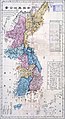 An 18th century map of Korea that shows two islands to the east of Korea in the approximate locations of Ulleungdo and Liancourt Rocks.
 -
![Daehan Jeondo (part, 1899, Korea) Showing Usando slightly northeast to Ulleungdo, both drawn just west of 37°40′N, 130°30′E. (whole images[1][2])](https://upload.wikimedia.org/wikipedia/commons/thumb/8/80/DaehanJeondo.jpg/120px-DaehanJeondo.jpg)
-
Cheonggudo (part, 1834, Korea) To scale map featuring Usan (于山), located in about 10 ri from Ulleungdo. (whole and enlarged images)Cheonggudo (part, 1834, Korea) To scale map featuring Usan (于山), located in about 10 ri from Ulleungdo. (whole and enlarged images)
-
Ulleungdo and the small neighboring island, Jukdo located in 2 km east. Jukdo is larger than the total area of Liancourt Rocks.


![Daehan Jeondo (part, 1899, Korea) Showing Usando slightly northeast to Ulleungdo, both drawn just west of 37°40′N, 130°30′E. (whole images[1][2])](https://thcscience.wiki/legality-of-cannabis-by-u-s-jurisdiction/?rdp_we_resource=https%3A%2F%2Fen.wikipedia.org%2Fwiki%2FFile%3ADaehanJeondo.jpg)
![[2]](http://ullungdo.com/map/image/12.jpg)
See also
- Japanese-Korean relations
- Japanese-Korean disputes
- Foreign relations of Japan
- Foreign relations of South Korea
- Dokdo class landing platform experimental
References
- ^ Charles Scanlon South Koreans vent fury at Japan BBC, 18 March 2005
- ^ Japan eyes expanding EEZ to counter S. Korean proposal, Kyodo News International
- ^ [3]
- ^ a b c d e f g h i Korea.net (1999–2006). Dokdo: A Profile. Retrieved 9 January, 2006.
- ^ a b c d e f g h i j k l Gyongsangbuk-do (2001). Cyber Dokdo. Retrieved 9 January, 2006.
- ^ a b c d e f g h i j k Truth of Dokdo. Story of Dokdo. Retrieved 9 January, 2006.
- ^ "독도, 일본보다 빠른 속도로 침몰하고 있다", The Korea Times, 2006/12/01. 손영관교수 `독도ㆍ울릉도 `침몰하고 있다``, JoongAng Ilbo, 2006/12/01.
- ^ DKB News. UL1.jpg. Retrieved 9 January, 2006.
- ^ See Hankooki.
- ^ See Cyber Dokdo.
- ^ Truth of Dokdo. Importance of Dokdo. Retrieved 9 January, 2006.
- ^ Historically,Takeshima belongs to Japan, Shimane Prefectural Government, Japan
- ^ (ko) "50년대 독도의용수비대가 활약할 당시만 해도 20∼30마리씩 떼를 지어 독도 연안에서 서식하는장면이 목격됐다. 독도의용수비대원이던 이규현씨(82·울릉군 울릉읍 도동리)는 "당시 독도에서 강치(바다사자) 무리를 간간이 볼 수 있었고, 울릉도 주민들은 이를 가재, 강치로 부르기도 했다"고 말했다." 독도에 바다사자 복원한다, The Kukmin Daily, 2006.02.02
- ^ a b c d e Korea.net (1999–2006). Dokdo: Inhabitants and Visitors. Retrieved 9 January, 2006.
- ^ Tour 2 Korea Dokdo Tour. Retrieved 18 January, 2006.
- ^ Kim Byong-kuk (2002-11-21). "Japan's Preposterous Claims on Tok-do". Korea Times. Retrieved 2007-01-21.
Historical verification goes back to the ``Samkuk Saki" (History of The Kingdoms: Koguryo, Paekche and Silla) authored by Kim Pu-sik which recorded that Silla Kingdom during the reign of King Chi-chung annexed in 512 A.D. the Usankuk (three peak islands of Ullung-do and Tok-do) in the East Sea.
{{cite web}}: Cite has empty unknown parameters:|accessyear=,|month=,|accessmonthday=, and|coauthors=(help) - ^ [4]
- ^ Cite error: The named reference
kcnawas invoked but never defined (see the help page). - ^ Jon M. Van Dyke (2007-01-18). "Who Owns Tok-Do/Takeshima? Should These Islets Affect the Maritime Boundary Between Japan and Korea?" (PDF). Retrieved 2007-01-23.
Japan's protests appear to have been sufficient to overcome a presumption of acquiescence, and thus if Korea's claim were based solely on its occupation of the islets since World War II, these protests could be seen as adequate to block a claim based on prescription.
{{cite web}}: Cite has empty unknown parameters:|accessyear=,|month=,|accessmonthday=, and|coauthors=(help) - ^ CIA (2007-01-18). "The world Fact Book". CIA. Retrieved 2007-01-23.
South Korea and Japan claim the Liancourt Rocks (Tok-do/Take-shima), occupied by South Korea since 1954.
{{cite web}}: Cite has empty unknown parameters:|accessyear=,|month=,|accessmonthday=, and|coauthors=(help) - ^ "About Takeshima". Shimane Prefectural Government. Retrieved 2007-01-27.
{{cite web}}: Cite has empty unknown parameter:|coauthors=(help) - ^ Template:Ko icon "十三年夏六月,于山國帰服,歳以士宜為貢于山國,在溟州正東海島,或名欝陵島,地方一百里,恃嶮不服,伊異斯夫,為何瑟羅州軍主,謂于山人愚悍難以威来,可以計服,乃多造木偶師子,分載戦船,抵其国海岸誑告白,汝若不服,則放此猛獣,踏殺之,國人恐懼則降." The character "do" (島) refers to island, whereas "guk" (國) refers to state/nation. See 三国史記「干山国帰服す」画像. 三国史記-卷四·新羅本紀·智証麻立干 智証王13年(512年)夏6月条.
- ^ Template:Ja icon "命議政府議處流山國島人江原道觀察使報云流山國島人白加勿等十二名來泊高城於羅津言曰予等生長武陵其島内人戸十一男女共六十餘今移居本島是島自東至西自南至北皆二息周回八息無牛馬水田唯種豆一斗出二十石或三十石麥一石出五十餘石竹如大椽海錯果木皆在焉竊慮此人等逃還姑分置于通州高城扞城" See 架空の「流山国島」が記された太宗実録12年4月巳巳条の原文画像.
- ^ 世宗實錄地理志江原道三陟都護府蔚珍縣 "于山、武陵二島在縣正東海中。二島相去不遠, 風日淸明, 則可望見。", National Institute of Korean History.
- ^ a b Korea.net (1999–2006). History of Dokdo. Retrieved 9 January, 2006.
- ^ 肅宗27巻,20年8月14日己酉 "本島峰巒樹木, 自陸地歴歴望見, 而凡其山川紆曲, 地形闊狭, 民居遺址, 土物所産, 倶載於我国《輿地勝覧》書, 歴代相伝, 事跡昭然", National Institute of Korean History.
- ^ See the English translation at the bottom of this link [5].
- ^ Template:Ja icon See Map which is on this page and part of the "竹島問題" site.
- ^ 太宗實錄 太宗33卷17年(1417)2月8日乙丑, National Institute of Korean History.
- ^ Dokdo Is Korean Territory, May 2005, Korea Foundation Newsletter.
- ^ Chronological Table of Takeshima, part of the Takeshima is Japanese Territory website maintained by Shimane Prefecture.
- ^ First Japanese Record on Tokdo from the First Written Records on Tokdo site maintained by Iwato Hashimori.
- ^ [対馬藩政史料 (国元表書札方)毎日記 元禄六年六月三日条] "向後弥不参候様二堅堅朝鮮表江被仰遣候様二御国元江被申越候様二と相模守申付候"
- ^ See Japanese government reconfirms Dokdo and Uleungdo as Korean territories at the end of 17th century on the Cyber Dokdo site.
- ^ See 鳥取藩政資料からみた竹島問題
- ^ See [6]
- ^ See New Destroyer to Be Named `Ahn Yong-bok', Korean Times, March 28, 2005.
- ^ See Japan Twice Admitted Korean Sovereignty Over Dokdo, Digital Chosun Ilbo, March 4, 2005.
- ^ See Shimane Prefecture site on Takeshima.
- ^ See Korea's Posessions.
- ^ See Chosen Hachido-no Zu, University of Tsukuba Library,.
- ^ See Dae Dong Yeo Ji Do map.
- ^ See Korean Government Imperial Ordinance 41
- ^ See Chosun
- ^ KBS
- ^ See http://toron.pepper.jp/jp/take/hennyu/ishijima41.html.
- ^ See http://www.geocities.com/mlovmo/page4.html
- ^ See Cyber Dokdo.
- ^ See Takeshima Position
- ^ See http://www.geocities.com/mlovmo/temp10.html.
- ^ SCAPIN677, Dokdo Center, 2005.09.09.
- ^ Who Owns Tok-Do/Takeshima? Should These Islets Affect the Maritime Boundary Between Japan and Korea?, Jon M. Van Dyke[7], p. 49.
- ^ SCAPIN-1033, Toron Talker.
- ^ See Rusk documents.
- ^ "CIA Records Say Japan Gave up Dokdo". KBS Global. 24. Retrieved 2006-06-07.
{{cite journal}}: Check date values in:|date=and|year=/|date=mismatch (help); Unknown parameter|month=ignored (help) - ^ a b (ko) "책갈피 속의 오늘 1952년 이승만 평화선 선포", Dong-a Ilbo, 2006/01/18. See also Rusk documents. Cite error: The named reference "DI-SMRLine" was defined multiple times with different content (see the help page).
- ^ a b (ko) "미국, 한국전직후 "독도는 일본땅" 일방결론", Segye Ilbo, 2006-03-27. See also Report of Van Fleet Mission to Far East.
- ^ See [8]
- ^ See [9]
- ^ (ko)"전설의 독도수비대, '영웅'은 없었다", OhmyNews, 2006-10-30.
- ^ (ko) 감사원 "독도수비대 일부 엉터리 훈장", mbn/Naver News 2007-04-19
- ^ "Shimane Prefectural Government website: Photo Shimane No. 161" (in Japanese). 2006. Retrieved 2006-05-07.
- ^ See Takeshima Position
- ^ See http://www.geocities.com/mlovmo/page4.html.
- ^ See Official guideline.
- ^ See Japan Post protest statement.
- ^ See Picture
- ^ See Jeju Times.
- ^ See Hankooki Times.
- ^ See Japan-South Korea Island Dispute, Yahoo! News, April 19, 2006.
- ^ See Hankooki Times.
- ^ See Japan-South Korea Island Dispute, Yahoo! News, April 19, 2006.
- ^ See Hankooki Times.
- ^ See Naver News.
- ^ See Naver News.
- ^ See Chosun
- ^ See Japan Times.
- ^ See Chosun.
- ^ See BBC News.
- ^ "Japan informs ROK of intended survey around disputed islets", Xinhua News Agency, 2006-08-02.
- ^ [10]
- ^ [11] Japan, S. Korea to discuss notification procedure for EEZ surveys
![[6]](http://homepage2.nifty.com/oppekepe/takeshima/eng/korea/Ahn_incident/img/ahn_map.jpg)
External links
- "Day on the Dokdo Islands", an American's photographs of his trip to the islets.
Official sites
- South Korean government's perspective on Dokdo via Korea.net
- Takeshima is Japanese territory: a web page by the Shimane Prefectural Government, Japan
- Japan's position on Takeshima by the Japanese Ministry of Foreign Affairs
- Cyber Dokdo System by Gyeongbuk provincial authorities
Pro-Korea
- Tokdo or Takeshima? The International Law of Territorial Acquisition in the Japan-Korea Island Dispute, Sean Fern, Stanford Journal of East Asian Affairs, Volume 5 Number 1 (Winter 2005), pp.78-89 Third party analysis of dispute in an academic journal
- Tokdo Dispute History by Kalani O'Sullivan Third party analysis of dispute in an academic journal
- The historical facts of the Dokdo - Takeshima Island dispute between Japan and Korea Third party analysis of dispute
- dodkdonews.net: News updates on the disputed islets
- The Territorial Dispute Over Dokdo, compiled by Mark S. Lovmo Third party analysis of dispute
- "North Korea Denounces Japanese Territorial Claims on Dokdo", Yonhap via Yahoo news
- Northeast Asian History Foundation in Korea
Pro-Japan
| |||||||||
| |||||||||