208.108.138.21 (talk) |
This lousy T-shirt (talk | contribs) |
||
| Line 7: | Line 7: | ||
==Island components== |
==Island components== |
||
The archipelago consists of 6,852 islands ("island" defined as land more than 100 m in circumference), of which 430 are inhabited.<ref>"Islands in Abundance", ' |
The archipelago consists of 6,852 islands ("island" defined as land more than 100 m in circumference), of which 430 are inhabited.<ref>"Islands in Abundance", ''Look Japan'' |
||
Volume 43, Issues 493–504, [http://books.google.co.uk/books?id=NHi6AAAAIAAJ&q=%226%2C852+islands%22 p. 37].</ref> The four main islands, from north to south, are [[Hokkaido]], [[Honshu]], [[Shikoku]], and [[Kyushu]]; Honshu is the largest and referred to as the Japanese mainland.<ref>[http://www.thefreedictionary.com/Japanese+Archipelago "Japanese Archipelago"], [[TheFreeDictionary.com]], retrieved 24 June 2013.</ref> |
|||
== Palaeogeography == |
== Palaeogeography == |
||
Revision as of 14:55, 11 February 2014


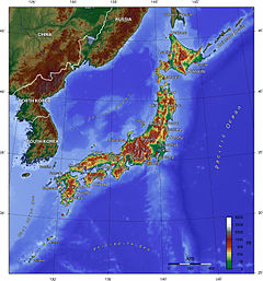
The Japanese archipelago (日本列島, Nihon Rettō) are the islands that form the country of Japan, and extends roughly from northeast to southwest along the northeastern coast of the Eurasia mainland, washing upon the northwestern shores of the Pacific Ocean. It consists of islands from the Sakhalin island arc and the Northeastern Japan arc.
The term Home Islands was used at the end of World War II to define the area of Japan to which its sovereignty and the constitutional rule of the Emperor would be restricted.[citation needed] The term is also commonly used today to distinguish the archipelago from Japan's colonies and other territories in the first half of the 20th century.[1]
Island components
The archipelago consists of 6,852 islands ("island" defined as land more than 100 m in circumference), of which 430 are inhabited.[2] The four main islands, from north to south, are Hokkaido, Honshu, Shikoku, and Kyushu; Honshu is the largest and referred to as the Japanese mainland.[3]
Palaeogeography
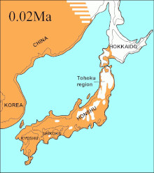
Changes to the Japanese archipelago over time:


| – regions above sea level | |
| (white color) – unvegetated land[clarification needed] | |
| – sea |
See also
References
- ^ Milton W. Meyer, Japan: A Concise History, 4th ed. Lanham, Maryland: Rowman & Littlefield, 2012, ISBN 9780742541184, p. 2.
- ^ "Islands in Abundance", Look Japan Volume 43, Issues 493–504, p. 37.
- ^ "Japanese Archipelago", TheFreeDictionary.com, retrieved 24 June 2013.
External links
- 37°30′52″N 137°42′44″E / 37.514444°N 137.712222°E, center of mass