Restored revision 1077186637 by Daniel boxs (talk): This is not a moderate tropical storm, please see MFR |
FleurDeOdile (talk | contribs) →Tropical Depression 08: readd JTWC designation that was removed for no reason |
||
| Line 217: | Line 217: | ||
|Dissipated=27 February <!-- merged with Tropical Storm Vernon --> |
|Dissipated=27 February <!-- merged with Tropical Storm Vernon --> |
||
|10-min winds=30 |
|10-min winds=30 |
||
|1-min winds=35 |
|||
|Pressure=998 |
|Pressure=998 |
||
}} |
}} |
||
Revision as of 18:00, 15 March 2022
| 2021–22 South-West Indian Ocean cyclone season | |
|---|---|
 Season summary map | |
| Seasonal boundaries | |
| First system formed | 20 January 2022 (record latest) |
| Last system dissipated | Season ongoing |
| Strongest storm | |
| Name | Batsirai |
| • Maximum winds | 195 km/h (120 mph) (10-minute sustained) |
| • Lowest pressure | 934 hPa (mbar) |
| Seasonal statistics | |
| Total disturbances | 9 |
| Total depressions | 9 |
| Total storms | 8 official, 1 unofficial |
| Tropical cyclones | 4 |
| Intense tropical cyclones | 4 |
| Very intense tropical cyclones | 0 |
| Total fatalities | 289 total |
| Total damage | > $53.3 million (2022 USD) |
| Related articles | |
The 2021–22 South-West Indian Ocean cyclone season is an ongoing event of the annual cycle of tropical cyclone and subtropical cyclone formation. The season began on 15 November 2021, and it will end on 30 April 2022, with the exception for Mauritius and the Seychelles, for which it will end on 15 May 2022. These dates conventionally delimit the period of each year when most tropical and subtropical cyclones form in the basin, which is west of 90°E and south of the Equator. However, tropical cyclones that form at any time between 1 July 2021 and 30 June 2022 will count towards the season total. Tropical and subtropical cyclones in this basin are monitored by the Regional Specialised Meteorological Centre in Réunion and unofficially by the Joint Typhoon Warning Center.
The season's first storm, Moderate Tropical Storm Ana, formed as a zone of disturbed weather on 20 January 2022, marking the latest first system in a Southwest Indian Ocean cyclone season ever.[1][2] The second, and strongest storm of the season so far, Cyclone Batsirai, formed on 24 January, and became a long-lived and powerful storm. It cruised west, and eventually made landfall in Madagascar as a Category 3-equivalent storm. Continuing the active period of development, Tropical Storm Dumako formed, struggling to intensify and making landfall in Madagascar later. Yet another storm, Cyclone Emnati, would strike extreme southern Madagascar as a Category 1-equivalent after peaking as a Category 4-equivalent beforehand. The third Intense Tropical Cyclone, Cyclone Vernon, passed into the basin as a Category 4-equivalent after very rapidly intensifying in the neighboring Australian region.
Seasonal summary

Systems
Moderate Tropical Storm Ana
| Moderate tropical storm (MFR) | |
| Tropical storm (SSHWS) | |
  | |
| Duration | 20 January – 25 January |
|---|---|
| Peak intensity | 85 km/h (50 mph) (10-min); 990 hPa (mbar) |
At 07:30 UTC on 20 January, the Joint Typhoon Warning Center began monitoring an area of convection, which they designated as Invest 93S, approximately 378 nmi (700 km; 435 mi) from Mauritius, with the agency giving a low chance for potential cyclogenesis within the next 24 hours.[3] Early the next day, at 02:00 UTC, the JTWC issued a Tropical Cyclone Formation Alert (TCFA) for Invest 93S, as the agency noted its consolidation of a well-defined low-level circulation (LLC).[4] Later at 12:00 UTC, the MFR declared the tropical low pressure system as a zone of disturbed weather, making it the first system of the season.[5] Twelve hours later, the MFR upgraded it to a tropical disturbance,[6] further upgrading it to a tropical depression by 06:00 UTC on 22 January.[7] Between 08:00 UTC and 09:00 UTC, the system's center crossed between Toamasina and Île Sainte-Marie as a tropical depression, with the MFR re-classifying the system as a overland depression.[8][9] Following landfall, the system weakened slightly, though its structure remained intact.[9] At 06:00 UTC the next day, the MFR re-classified it again as a tropical disturbance after entering the Mozambique Channel.[10] Six hours later, it re-intensified into a tropical depression, as it gradually regained its structure.[11] At 15:00 UTC on 23 January, the JTWC declared the system a tropical cyclone and designated it 07S.[12] The MFR later upgraded it to a moderate tropical storm and named it Ana, making it the first named storm of the season.[13] Ana maintained its intensity until at 08:00 UTC the same day, when it made landfall near south of Angoche, Mozambique.[14][15] The system later moved westwards as an overland depression, crossing across southern Malawi and northern Zimbabwe, and by midday of 25 January, it became a remnant low over the adjoining areas of Zimbabwe and Zambia.[16] The remnant later moved towards Angola and was last noted on 30 January around Namibia and Angola.[17]
Despite being a weak system, Ana caused devastating floods in Madagascar, Malawi, and Mozambique, killing 115 people in total.[18][19][20] Before becoming a moderate tropical storm, Ana made landfall as a tropical depression in Madagascar, causing heavy rainfall which led to deadly landslides and floods; it caused 58 fatalities in the country.[18] An estimated 55,000 people had become homeless and 130,000 were forced to flee to temporary habitation centres.[21][22] In Mozambique, at least 20 people had died and 10,000 homes had been destroyed. An additional 20,000 were affected by the cyclone.[20][22] In Malawi, 200,000 people had been displaced and 37 fatalities had been reported, with additional 22 being missing.[19] Catastrophic flooding caused severe damages to infrastructure and powerlines, which led to severe power outages in the affected areas.[22] The Kapichira hydroelectric dam was badly damaged due to the flash floods. Because of this, the government of Malawi declared a state of natural disaster.[23]
Intense Tropical Cyclone Batsirai
| Intense tropical cyclone (MFR) | |
| Category 4 tropical cyclone (SSHWS) | |
  | |
| Duration | 24 January – 8 February |
|---|---|
| Peak intensity | 195 km/h (120 mph) (10-min); 934 hPa (mbar) |
On 23 January, the JTWC noted an area of convection over the eastern part of the basin, located approximately 493 nmi (913 km; 567 mi) from the Cocos Islands. The agency gave a low chance for potential cyclogenesis in the next day.[24] Later at 21:30 UTC the same day, the agency issued a TCFA for the system after noting an obscure LLC.[25] At midday on 25 January, the MFR recognized the same low pressure system and later upgraded it to a tropical disturbance at 06:00 UTC the next day.[26][27] The MFR further upgraded it to a tropical depression at 12:00 UTC on 26 January, as it continued to improve its convective structure.[28] After its convective activity was briefly interrupted after 18:00 UTC due to dry air,[29] the JTWC recognized the system as a tropical cyclone at 03:00 UTC the next day.[30] The MFR followed three hours later, by upgrading it to a moderate tropical storm and naming it Batsirai.[31] Between 06:00 UTC and 12:00 UTC, Batsirai underwent rapid deepening and intensified from a moderate tropical storm to an intense tropical cyclone within three hours, establishing an inner core 75 to 90 km (45 to 55 mi) in diameter.[32] Two hours later, the JTWC upgraded it to a Category 2 tropical cyclone, as it developed a small eye at about 7 nmi (13 km; 8.1 mi) in diameter.[33] However, by 18:00 UTC, it started to rapidly weaken after its eye quickly collapsed and the cloud tops had warmed. Because of these reasons, the MFR downgraded it to a tropical cyclone.[34] At midnight on 28 January, it was further downgraded to a moderate tropical storm, after further weakening of the convective structure.[35] Three hours later, the JTWC downgraded it to tropical storm status.[36]
Batsirai resumed its intensification after re-intensifying to a severe tropical storm status at 06:00 UTC the next day.[37] Nine hours later, the JTWC upgraded it to a Category 1 tropical cyclone,[38] before further upgrading it to a Category 2 tropical cyclone after noting a well-defined central dense overcast (CDO) and a microwave eye feature at 03:00 UTC on 30 January.[39] The MFR further upgraded it to a tropical cyclone status at midday.[40] Three hours later, the JTWC upgraded it to a Category 3 tropical cyclone, as it developed a 5 nmi (9.3 km; 5.8 mi) wide pinhole-eye.[41] However, it was short-lived and it weakened to Category 1 status by 03:00 UTC on 1 February, as its eye collapsed and its eyewall became disorganized.[42][43] By 15:00 UTC the same day, however, it strengthened back to Category 2 status, consolidating and regaining a visible eye on satellite imagery.[44] Three hours later, the MFR upgraded it to an intense tropical cyclone.[45] By 03:00 UTC on 2 February, it went through another round of rapid intensification, strengthening from a Category 2 to a Category 4 tropical cyclone, according to the JTWC.[46] Its eyewall rapidly organized, developing a 15 nmi (28 km; 17 mi) wide eye.[46] After reaching its peak at 12:00 UTC, satellite imagery depicted the formation of another eyewall, though it showed signs of weakening by 15:00 UTC, indicating the beginning of an eyewall replacement cycle.[47][48]
Moderate Tropical Storm Cliff
| Moderate tropical storm (MFR) | |
| Tropical storm (SSHWS) | |
  | |
| Duration | 3 February – 5 February |
|---|---|
| Peak intensity | 75 km/h (45 mph) (10-min); 994 hPa (mbar) |
On 31 January, the MFR reported the formation of a weak area of low pressure east of Cyclone Batsirai,[49] which the JTWC recognized as Invest 90S at 08:00 UTC of 2 January.[50] Two days later at 03:00 UTC, the JTWC issued a TCFA for the invest,[51] upgrading it to a tropical cyclone shortly after, noting the defined but obscured LLC.[52] At midday, the MFR followed, and declared the same low as a tropical depression.[53] Later in the evening, the MFR upgraded it to a moderate tropical storm and was given the name Cliff.[54] By midnight of February 5, Cliff weakened as it lost organization, with its convection being displaced south of its LLC.[55] By 06:00 UTC, Cliff further weakened due to an intrusion of dry air and further strengthening of northwesterly wind shear.[56] Six hours later, the MFR issued its last bulletin and declared it as a "filling up" low.[57] On the next day at 21:00 UTC, the JTWC also issued its final warning on Cliff.[58] The remnants of Cliff meandered in the open-sea and briefly passed west of the Reunion island on 11 February,[59] dissipating completely on 12 February.[60]
Moderate Tropical Storm Dumako
| Moderate tropical storm (MFR) | |
| Tropical storm (SSHWS) | |
  | |
| Duration | 10 February – 18 February |
|---|---|
| Peak intensity | 85 km/h (50 mph) (10-min); 993 hPa (mbar) |
On 10 February, MFR began monitoring an area of disturbed weather,[61] with the JTWC designating the system as an invest a day later.[62] By 12 February, it had been upgraded to a tropical disturbance by MFR, before being upgraded to a tropical depression later that day.[61] The JTWC assessed that the system had developed into a tropical cyclone on 13 February, giving it the designation 12S.[63] MFR upgraded the system to a moderate tropical storm later that day, being given the name Dumako by the Mauritius Meteorological Service.[64] By 14 February at 00:00 UTC, MFR estimated Dumako to have peaked in intensity, with maximum 10-minute sustained winds of 85 kilometres per hour (50 mph) and a minimum central pressure of 993 hPa (29.32 inHg).[61] Dumako continued westward, and by the next day, it had made landfall near Sainte-Marie Island.[65] MFR downgraded Dumako to a tropical depression later that day,[61] with the JTWC doing the same at 00:00 UTC on 16 February.[66] Dumako re-emerged over water on the same day,[67] before being assessed to have lost tropical depression status by MFR on 17 February. Dumako dissipated on 18 February as it made landfall over Mozambique close to the city of Quelimane.[61]
14 people died as a result of Dumako, with four thousand people having been displaced.[68]
Intense Tropical Cyclone Emnati
| Intense tropical cyclone (MFR) | |
| Category 4 tropical cyclone (SSHWS) | |
  | |
| Duration | 15 February – 24 February |
|---|---|
| Peak intensity | 175 km/h (110 mph) (10-min); 940 hPa (mbar) |
Emnati initially developed as a zone of disturbed weather, where it moved westwards over the open waters in Indian Ocean. Environmental conditions were assessed as being marginally conducive for tropical cyclogenesis, with the disturbance being located about 420 nautical miles (780 km; 480 mi) south of Diego Garcia.[69][70] On the same day, the JTWC issued a Tropical Cyclone Formation Alert for the system, and by 21:00 UTC, the JTWC initiated advisories on the system and classified it as Tropical Cyclone 13S.[71] The next day, the system organized into a tropical disturbance.[72] The system continued organizing, and at 12:00 UTC, MFR upgraded the system to a tropical depression.[73] By 17 February, the MFR reported that the system had become a moderate tropical storm, and the Sub-Regional Tropical Cyclone Advisory Center in Mauritius named it Emnati.[74][75] It underwent a period of rapid intensification, gaining hurricane-force winds according to the JTWC, before ceasing intensification due to cool waters upwelled by Cyclone Batsirai. Its intensity fluctuated for two days, before undergoing another period of rapid intensification on 20 February to become a Category 3-equivalent tropical cyclone. Continuing to intensify, at 12:00 UTC of the same day, the cyclone peaked as an intense tropical cyclone, with the MFR estimating 10-minute sustained winds of 175 kilometres per hour (110 mph) with a minimum central pressure of 940 hPa. The JTWC estimated it to have peaked as a Category 4-equivalent tropical cyclone with 1-minute sustained winds of 215 kilometres per hour (130 mph). Shortly after reaching its peak intensity, due to the upwelled sea and an eyewall replacement cycle, the storm began to weaken below intense tropical cyclone intensity by 06:00 UTC on the next day. Similarly, the land interaction with Madagascar affected the storm's overall structure. At 23:00 UTC on 22 February, the storm made landfall near Manakara with winds of 120 kilometres per hour (75 mph) according to both MFR and the JTWC. Weakening slowly, it entered into the Mozambique channel at 21:00 UTC of the next day. Due to cooler waters and very high wind shear, it began to transition into a subtropical cyclone, with the JTWC issued its final warning at 21:00 UTC on 24 February and MFR doing the same six hours earlier.[citation needed]
Moderate Tropical Storm Fezile
| Moderate tropical storm (MFR) | |
  | |
| Duration | 16 February (Entered basin) – 18 February |
|---|---|
| Peak intensity | 85 km/h (50 mph) (10-min); 980 hPa (mbar) |
During 16 February, the MFR reported that a low-pressure system which was labelled as Tropical Low 19U by the Australian Bureau of Meteorology entered the basin. The agency re-assessed it as Zone of Disturbed Weather 06, with the system having an ill-defined center and fluctuating convection.[76] On the same day, the JTWC issued a TCFA following deepening of the system's convective bands and the organization of its LLC.[77] After maintaining the same intensity for two days, the system intensified into a moderate tropical storm at midnight of 18 February. The Mauritius Meteorological Service named the storm as Fezile. The system's cloud pattern rapidly organized, with numerous satellite imagery depicting the formation of curved bands.[78] However, three hours later, the JTWC cancelled its TCFA as the system started its subtropical transition,[79] with the MFR noting its convective structure weakening and being continuously sheared by 06:00 UTC.[80] Fezile's structure was continually affected by wind shear,[81] until evening, when Fezile became a post-tropical cyclone and began extratropical transition.[82] Fezile completely dissipated shortly after.[83]
Intense Tropical Cyclone Vernon
| Intense tropical cyclone (MFR) | |
| Category 4 tropical cyclone (SSHWS) | |
  | |
| Duration | 26 February (Entered basin) – 3 March |
|---|---|
| Peak intensity | 195 km/h (120 mph) (10-min); 950 hPa (mbar) |
On 26 February, when Vernon entered the MFR's area of responsibility (AoR), it was assessed as an intense tropical cyclone on the SWIO scale, with maximum 10-minute sustained winds of 195 km/h (120 mph) and a central atmospheric pressure of 950 hPa (28.47 inHg).[84][85] At this time, the JTWC subsequently reported that the cyclone reached Category 4-equivalent status on the Saffir–Simpson scale. This was short-lived, however, as it began a Fujiwhara interaction with Tropical Depression 08 to its northwest, causing it to weaken rapidly to a tropical storm. Maintaining its intensity, it soon entered into favourable conditions in which the storm peaked again as a severe tropical storm according to MFR, with winds estimated at 95 kilometres per hour (60 mph). However, by 2 March, it began to undergo subtropical transition as it entered deeper latitudes, and the JTWC issued ites final warning on 21:00 UTC of the same day. The MFR tracked the system until 18:00 UTC of 3 March.
Tropical Depression 08
| Tropical depression (MFR) | |
| Tropical storm (SSHWS) | |
  | |
| Duration | 23 February – 27 February |
|---|---|
| Peak intensity | 55 km/h (35 mph) (10-min); 998 hPa (mbar) |
Tropical Depression 08 initially formed on 23 February as a low-pressure area, which was located very close to Cyclone Vernon.[86] Two days later, the JTWC started to monitor the same disturbance as Invest 93S.[87] At 06:00 UTC of 27 February, the MFR upgraded it to a tropical depression as it orbited near Vernon.[86] After maintaining its convection for a day, the MFR issued its last advisory for Tropical Depression 08, as it underwent a Fujiwhara interaction with Vernon. Its convection had decayed and its low-level center had became ill-defined as a result of the interaction,[88] and due to this, the JTWC had also stopped monitoring the invest on the next day.[89]
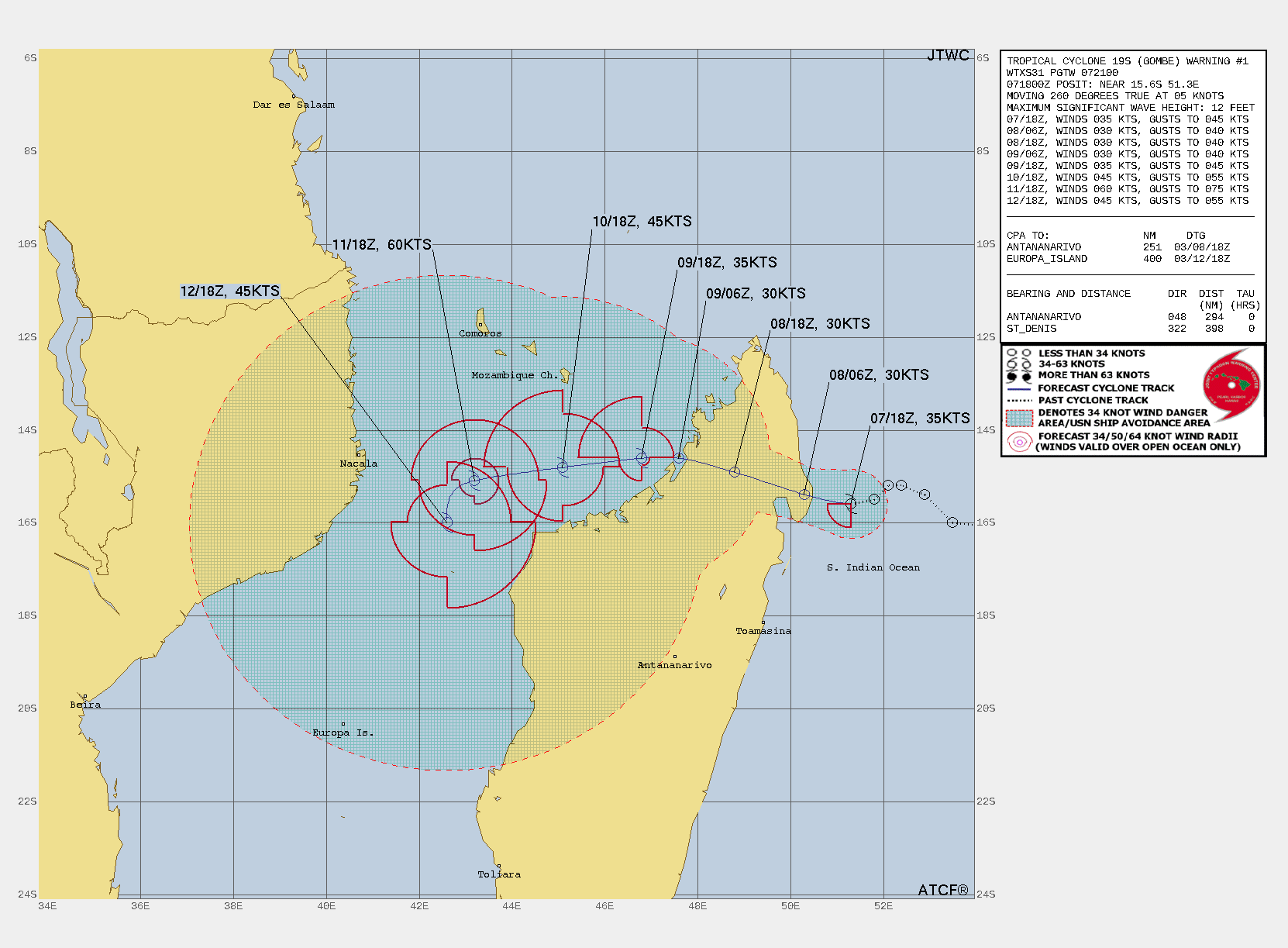
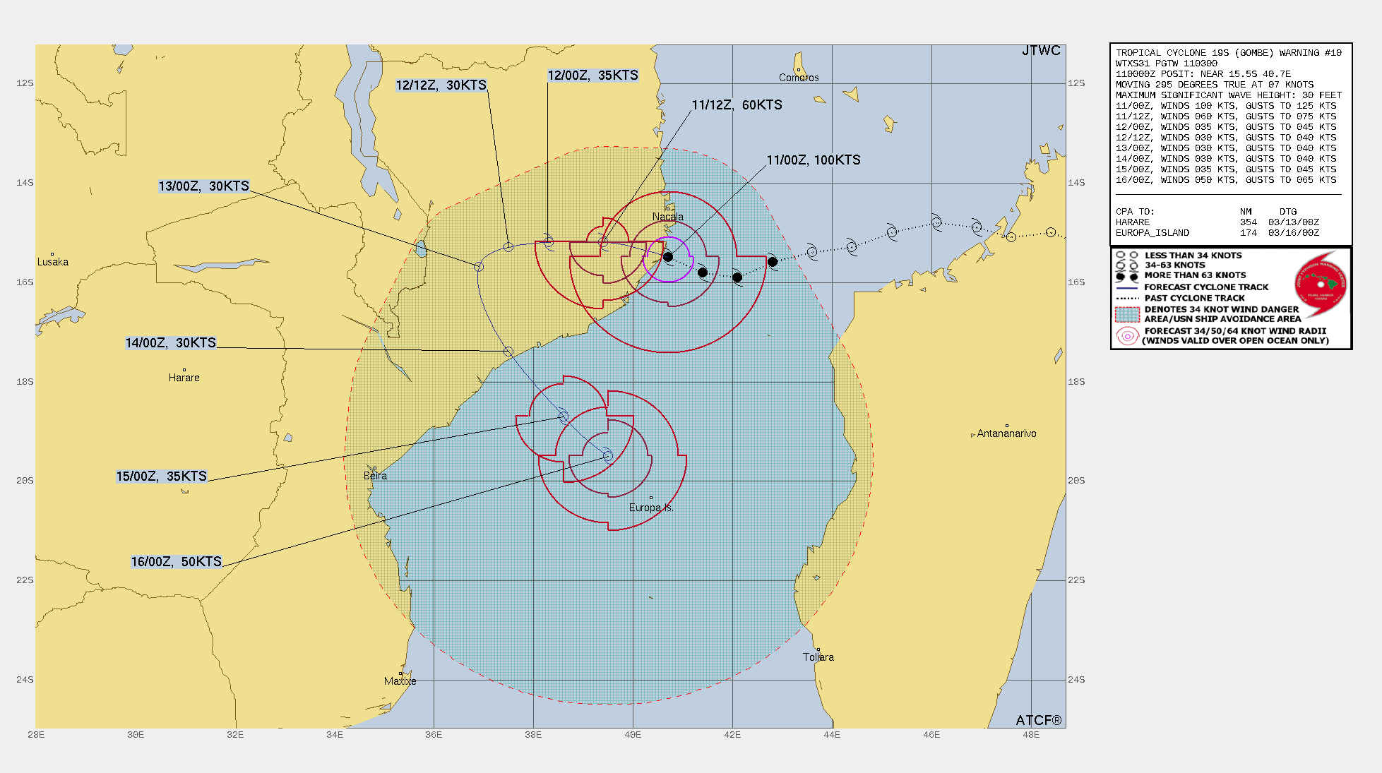
Intense Tropical Cyclone Gombe
| Intense tropical cyclone (MFR) | |
| Category 3 tropical cyclone (SSHWS) | |
  | |
| Duration | 5 March – 13 March |
|---|---|
| Peak intensity | 165 km/h (105 mph) (10-min); 960 hPa (mbar) |
On 6 March, the MFR began to monitor a zone of disturbed weather located approximately 280 nmi (520 km; 320 mi) from Mauritius, moving northwards.[90] The JTWC later tagged the system as Invest 97S, and issued a TCFA for the storm at 11:40 UTC on 6 March.[91] The next day, the MFR upgraded it to a tropical depression on 12:00 UTC, with it being named Moderate Tropical Storm Gombe six hours later. The JTWC followed, upgrading Gombe to a tropical storm with winds of 35 kn (65 km/h; 40 mph) at 18:00 UTC on 7 March.[92][93] The MFR re-classified Gombe as an overland depression at 06:00 UTC as it made landfall in northern Madagascar on 8 March,[94] and the JTWC downgraded the storm to a tropical depression.[95] 24 hours later, Gombe emerged over the Mozambique Channel, and strengthened back to a tropical storm.[96] Gombe gradually re-built its structure, and then intensified to a high-end tropical storm late on 9 March, and gained Category 1-equivalent winds by 06:00 UTC on 10 March.[97] As it neared landfall on Nampula Province, it underwent rapid intensification and strengthened from 65 to 100 kn (120 to 185 km/h; 75 to 115 mph) in 18 hours.[98] The MFR upgraded Gombe to the fourth Intense Tropical Cyclone of the year at the same time.[99] Following Gombe's landfall in Mozambique, it proceeded to lose most of its convection the next day. The MFR downgraded the storm to an Overland Depression for the second time on 06:00 UTC on 11 March.[100]
According to press reports, so far 22 people have died as a result of the cyclone passing through Mozambique.[101] At least 115,000 people were affected by the cyclone.[102]
Storm names
Within the South-West Indian Ocean, tropical depressions and subtropical depressions that are judged to have 10-minute sustained windspeeds of 65 km/h (40 mph) by the Regional Specialized Meteorological Center on Réunion island, France (RSMC La Réunion) are usually assigned a name. However, it is the Sub-Regional Tropical Cyclone Advisory Centers in Mauritius and Madagascar who name the systems. The Sub-Regional Tropical Cyclone Advisory Center (Mauritius Meteorological Services) in Mauritius names a storm should it intensify into a moderate tropical storm between 55°E and 90°E. If instead a cyclone intensifies into a moderate tropical storm between 30°E and 55°E then the Sub-Regional Tropical Cyclone Advisory Center (Madagascar Meteorological Services) in Madagascar assigns the appropriate name to the storm. Storm names are taken from three pre-determined lists of names, which rotate on a triennial basis, with any names that have been used automatically removed. Therefore, all storm names used this year will be removed from the rotation and replaced with a new name for the 2024–25 season, while the unused names will remain on the list.[103] New names this season are: Ana, Batsirai, Cliff, Dumako, Emnati, Fezile, Gombe, Halima, Issa, Jasmine, Karim, and Letlama. They replaced Alcide, Bouchra, Cilida, Desmond, Eketsang, Funani, Gelena, Haleh, Idai, Joaninha, Kenneth, and Lorna after the 2018–19 season.
|
|
If a tropical cyclone enters the South-West Indian basin from the Australian region basin (west of 90°E), it will retain the name assigned to it by the Australian Bureau of Meteorology (BoM). The following storms were named in this manner:
- Vernon
Season effects
This table lists all of the tropical cyclones and subtropical cyclones that were monitored during the 2021–2022 South-West Indian Ocean cyclone season. Information on their intensity, duration, name, areas affected, primarily comes from RSMC La Réunion. Death and damage reports come from either press reports or the relevant national disaster management agency while the damage totals are given in 2021 or 2022 USD.
| Name | Dates | Peak intensity | Areas affected | Damage (USD) |
Deaths | Refs | ||
|---|---|---|---|---|---|---|---|---|
| Category | Wind speed | Pressure | ||||||
| Ana | 20 – 25 January | Moderate tropical storm | 85 km/h (50 mph) | 990 hPa (29.23 inHg) | Mauritius, Madagascar, Mozambique, South Africa, Malawi, Zimbabwe, Zambia | Unknown | 115 | [18][19][20] |
| Batsirai | 24 January – 8 February | Intense tropical cyclone | 195 km/h (120 mph) | 934 hPa (27.58 inHg) | Mauritius, Réunion, Madagascar | > $53.3 million | 123 | [104][105] |
| Cliff | 3 – 5 February | Moderate tropical storm | 75 km/h (45 mph) | 994 hPa (29.35 inHg) | None | None | None | |
| Dumako | 10 – 18 February | Moderate tropical storm | 85 km/h (50 mph) | 993 hPa (29.32 inHg) | Madagascar, Mozambique | Unknown | 14 | [106] |
| Emnati | 15 – 24 February | Intense tropical cyclone | 175 km/h (110 mph) | 940 hPa (27.76 inHg) | Mauritius, Réunion, Madagascar | Unknown | 15 | [107] |
| Fezile | 16 – 18 February | Moderate tropical storm | 75 km/h (45 mph) | 980 hPa (28.94 inHg) | None | None | None | |
| Vernon | 26 February – 3 March | Intense tropical cyclone | 195 km/h (120 mph) | 950 hPa (28.05 inHg) | None | None | None | |
| 08 | 23 – 27 February | Tropical depression | 55 km/h (35 mph) | 998 hPa (29.47 inHg) | None | None | None | |
| Gombe | 5 March – 13 March | Intense tropical cyclone | 165 km/h (105 mph) | 960 hPa (28.35 inHg) | Madagascar, Mozambique, Malawi | Unknown | 22 | [108][109][110] |
| Season aggregates | ||||||||
| 9 systems | 20 January – Season ongoing | 195 km/h (120 mph) | 934 hPa (27.58 inHg) | > $53.3 million | 289 | |||
See also
- Weather of 2021 and 2022
- List of Southern Hemisphere cyclone seasons
- Tropical cyclones in 2021 and 2022
- Atlantic hurricane seasons: 2021, 2022
- Pacific hurricane seasons: 2021, 2022
- Pacific typhoon seasons: 2021, 2022
- North Indian Ocean cyclone seasons: 2021, 2022
- 2021–22 Australian region cyclone season
- 2021–22 South Pacific cyclone season
References
- ^ "Cronaca meteo. Africa, la tempesta tropicale Ana fa landfall in Mozambico". 3BMeteo | Previsioni Meteo (in Italian). 24 January 2022. Archived from the original on 26 January 2022. Retrieved 26 January 2022.
- ^ The Meteorological Office [@metofficestorms] (24 January 2022). "Tropical Storm #Ana has formed and will soon be making landfall over #Mozambique. The 2021-22 season in the Southwest Indian Ocean is making an unusually late start - Ana is the latest that the first named storm of the season has formed since 1998" (Tweet). Exeter, Devon, UK. – via Twitter.
- ^ Significant Tropical Weather Advisory for the Indian Ocean Reissued (Report). United States Joint Typhoon Warning Center. 20 January 2022. Archived from the original on 20 January 2022. Retrieved 23 January 2022.
- ^ Tropical Cyclone Formation Alert (Invest 93S) (Report). United States Joint Typhoon Warning Center. 21 January 2022. Archived from the original on 20 January 2022. Retrieved 23 January 2022.
- ^ "Zone of Disturbed Weather 1 Warning Number 1/1/20212022" (PDF). La Réunion, France: Météo-France. 21 January 2022. Archived (PDF) from the original on 24 January 2022. Retrieved 23 January 2022.
- ^ "Tropical Disturbance 1 Warning Number 2/1/20212022" (PDF). La Réunion, France: Météo-France. 22 January 2022. Archived (PDF) from the original on 22 January 2022. Retrieved 23 January 2022.
- ^ "Tropical Depression 1 Warning Number 3/1/20212022" (PDF). La Réunion, France: Météo-France. 22 January 2022. Archived (PDF) from the original on 22 January 2022. Retrieved 24 January 2022.
- ^ "Overland Depression 1 Warning Number 4/1/20212022" (PDF). La Réunion, France: Météo-France. 22 January 2022. Archived (PDF) from the original on 24 January 2022. Retrieved 24 January 2022.
- ^ a b "Overland Depression 1 Warning Number 5/1/20212022" (PDF). La Réunion, France: Météo-France. 22 January 2022. Archived (PDF) from the original on 23 January 2022. Retrieved 24 January 2022.
- ^ "Tropical Disturbance 1 Warning Number 7/1/20212022" (PDF). La Réunion, France: Météo-France. 23 January 2022. Archived (PDF) from the original on 23 January 2022. Retrieved 24 January 2022.
- ^ "Tropical Disturbance 1 Warning Number 8/1/20212022" (PDF). La Réunion, France: Météo-France. 23 January 2022. Archived (PDF) from the original on 23 January 2022. Retrieved 24 January 2022.
- ^ Prognostic Reasoning for Tropical Cyclone 07S (Seven) Warning No. 1 (Report). United States Joint Typhoon Warning Center. 23 January 2022. Archived from the original on 23 January 2022. Retrieved 24 January 2022.
- ^ "Moderate Tropical Storm 1 (Ana) Warning Number 10/1/20212022" (PDF). La Réunion, France: Météo-France. 24 January 2022. Archived (PDF) from the original on 24 January 2022. Retrieved 24 January 2022.
- ^ "Moderate Tropical Storm 1 (Ana) Warning Number 12/1/20212022" (PDF). La Réunion, France: Météo-France. 24 January 2022. Archived (PDF) from the original on 3 February 2022. Retrieved 1 February 2022.
- ^ "Bulletin for Cyclonic Activity and Significant Tropical Weather in the Southwestern Indian Ocean" (PDF). La Réunion, France: Météo-France. 24 January 2022. Archived (PDF) from the original on 1 February 2022. Retrieved 1 February 2022.
- ^ "Overland Depression 1 (Ana) Warning Number 16/1/20212022" (PDF). La Réunion, France: Météo-France. 25 January 2022. Archived (PDF) from the original on 1 February 2022. Retrieved 2 February 2022.
- ^ "Bulletin for Cyclonic Activity and Significant Tropical Weather in the Southwestern Indian Ocean" (PDF). La Réunion, France: Météo-France. 30 January 2022. Archived (PDF) from the original on 1 February 2022. Retrieved 2 February 2022.
- ^ a b c "Southern Africa: Cyclone Season Flash Update No. 2 (4 February 2022)". ReliefWeb. United Nations Office for the Coordination of Humanitarian Affairs. Retrieved 6 February 2022.
{{cite web}}: CS1 maint: url-status (link) - ^ a b c "Malawi, Africa | Tropical Storm Ana 2022 - Emergency Appeal n° MDRMW015 - Malawi". ReliefWeb. Archived from the original on 6 February 2022. Retrieved 5 February 2022.
- ^ a b c "Dozens killed in Tropical Storm Ana as southern Africa braces for more wild weather". The Guardian. Archived from the original on 6 February 2022. Retrieved 28 January 2022.
- ^ Gregory Gondwe (25 January 2022). "Malawi hit by flooding caused by tropical storm Ana; 1 dead". apnews.com. Blantyre, Malawi: The Associated Press. Archived from the original on 1 February 2022. Retrieved 2 February 2022.
- ^ a b c "Storm Ana kills dozens in Malawi, Madagascar and Mozambique". www.bbc.com. British Broadcasting Channel (BBC). 28 January 2022. Archived from the original on 3 February 2022. Retrieved 2 February 2022.
- ^ "Storm Ana kills at least three in Mozambique and Malawi". www.reuters.com. Maputo, Mozambique: Reuters. 26 January 2022. Archived from the original on 2 February 2022. Retrieved 2 February 2022.
- ^ Significant Tropical Weather Advisory for the Indian Ocean Reissued (Report). United States Joint Typhoon Warning Center. 23 January 2022. Archived from the original on 23 January 2022. Retrieved 29 January 2022.
- ^ Tropical Cyclone Formation Alert (Invest 96S) (Report). United States Joint Typhoon Warning Center. 24 January 2022. Archived from the original on 24 January 2022. Retrieved 29 January 2022.
- ^ "Bulletin for Cyclonic Activity and Significant Tropical Weather in the Southwestern Indian Ocean" (PDF). La Réunion, France: Météo-France. 25 January 2022. Retrieved 29 January 2022.
{{cite web}}: CS1 maint: url-status (link) - ^ "Tropical Disturbance 2 Warning Number 1/2/20212022" (PDF). La Réunion, France: Météo-France. 26 January 2022. Retrieved 29 January 2022.
{{cite web}}: CS1 maint: url-status (link) - ^ "Tropical Depression 2 Warning Number 2/2/20212022" (PDF). La Réunion, France: Météo-France. 26 January 2022. Retrieved 29 January 2022.
{{cite web}}: CS1 maint: url-status (link) - ^ "Tropical Depression 2 Warning Number 3/2/20212022" (PDF). La Réunion, France: Météo-France. 26 January 2022. Retrieved 29 January 2022.
{{cite web}}: CS1 maint: url-status (link) - ^ Prognostic Reasoning for Tropical Cyclone 08S (Eight) Warning No. 1 (Report). United States Joint Typhoon Warning Center. 27 January 2022. Archived from the original on 27 January 2022. Retrieved 29 January 2022.
- ^ "Moderate Tropical Storm 2 (Batsirai) Warning Number 5/2/20212022" (PDF). La Réunion, France: Météo-France. 27 January 2022. Retrieved 29 January 2022.
{{cite web}}: CS1 maint: url-status (link) - ^ "*CORRECTED* Intense Tropical Cyclone 2 (Batsirai) Warning Number 6/2/20212022" (PDF). La Réunion, France: Météo-France. 27 January 2022. Retrieved 29 January 2022.
{{cite web}}: CS1 maint: url-status (link) - ^ Prognostic Reasoning for Tropical Cyclone 08S (Batsirai) Warning No. 2 (Report). United States Joint Typhoon Warning Center. 27 January 2022. Archived from the original on 27 January 2022. Retrieved 29 January 2022.
- ^ "Tropical Cyclone 2 (Batsirai) Warning Number 7/2/20212022" (PDF). La Réunion, France: Météo-France. 27 January 2022. Retrieved 29 January 2022.
{{cite web}}: CS1 maint: url-status (link) - ^ "Moderate Tropical Storm 2 (Batsirai) Warning Number 8/2/20212022" (PDF). La Réunion, France: Météo-France. 28 January 2022. Retrieved 29 January 2022.
{{cite web}}: CS1 maint: url-status (link) - ^ Prognostic Reasoning for Tropical Cyclone 08S (Batsirai) Warning No. 3 (Report). United States Joint Typhoon Warning Center. 28 January 2022. Archived from the original on 28 January 2022. Retrieved 29 January 2022.
- ^ "Severe Tropical Storm 2 (Batsirai) Warning Number 13/2/20212022" (PDF). La Réunion, France: Météo-France. 29 January 2022. Retrieved 31 January 2022.
{{cite web}}: CS1 maint: url-status (link) - ^ Prognostic Reasoning for Tropical Cyclone 08S (Batsirai) Warning No. 6 (Report). United States Joint Typhoon Warning Center. 29 January 2022. Archived from the original on 31 January 2022. Retrieved 31 January 2022.
- ^ Prognostic Reasoning for Tropical Cyclone 08S (Batsirai) Warning No. 7 (Report). United States Joint Typhoon Warning Center. 30 January 2022. Archived from the original on 31 January 2022. Retrieved 31 January 2022.
- ^ "Tropical Cyclone 2 (Batsirai) Warning Number 18/2/20212022" (PDF). La Réunion, France: Météo-France. 30 January 2022. Retrieved 31 January 2022.
{{cite web}}: CS1 maint: url-status (link) - ^ Prognostic Reasoning for Tropical Cyclone 08S (Batsirai) Warning No. 8 (Report). United States Joint Typhoon Warning Center. 30 January 2022. Archived from the original on 31 January 2022. Retrieved 31 January 2022.
- ^ Prognostic Reasoning for Tropical Cyclone 08S (Batsirai) Warning No. 10 (Report). United States Joint Typhoon Warning Center. 31 January 2022. Archived from the original on 31 January 2022. Retrieved 3 February 2022.
- ^ Prognostic Reasoning for Tropical Cyclone 08S (Batsirai) Warning No. 11 (Report). United States Joint Typhoon Warning Center. 31 January 2022. Archived from the original on 31 January 2022. Retrieved 3 February 2022.
- ^ Prognostic Reasoning for Tropical Cyclone 08S (Batsirai) Warning No. 12 (Report). United States Joint Typhoon Warning Center. 1 February 2022. Archived from the original on 1 February 2022. Retrieved 3 February 2022.
- ^ "Intense Tropical Cyclone 2 (Batsirai) Warning Number 27/2/20212022" (PDF). La Réunion, France: Météo-France. 1 February 2022. Retrieved 3 February 2022.
{{cite web}}: CS1 maint: url-status (link) - ^ a b Prognostic Reasoning for Tropical Cyclone 08S (Batsirai) Warning No. 13 (Report). United States Joint Typhoon Warning Center. 1 February 2022. Archived from the original on 1 February 2022. Retrieved 3 February 2022.
- ^ Prognostic Reasoning for Tropical Cyclone 08S (Batsirai) Warning No. 14 (Report). United States Joint Typhoon Warning Center. 2 February 2022. Archived from the original on 2 February 2022. Retrieved 3 February 2022.
- ^ "Intense Tropical Cyclone 2 (Batsirai) Warning Number 27/2/20212022" (PDF). La Réunion, France: Météo-France. 2 February 2022. Retrieved 3 February 2022.
{{cite web}}: CS1 maint: url-status (link) - ^ "Bulletin for Cyclonic Activity and Significant Tropical Weather in the Southwestern Indian Ocean" (PDF). La Réunion, France: Météo-France. 31 January 2022. Retrieved 18 February 2022.
{{cite web}}: CS1 maint: url-status (link) - ^ Significant Tropical Weather Advisory for the Indian Ocean Reissued (Report). United States Joint Typhoon Warning Center. 2 February 2021. Archived from the original on 2 February 2022. Retrieved 18 February 2022.
- ^ Tropical Cyclone Formation Alert (Invest 90S) (Report). United States Joint Typhoon Warning Center. 4 February 2021. Archived from the original on 4 February 2022. Retrieved 18 February 2022.
- ^ Prognostic Reasoning for Tropical Cyclone 10S (Ten) Warning No. 1 (Report). United States Joint Typhoon Warning Center. 4 February 2021. Archived from the original on 4 February 2022. Retrieved 18 February 2022.
- ^ "Tropical Depression 3 Warning Number 1/3/202122" (PDF). La Réunion, France: Météo-France. 4 February 2022. Retrieved 18 February 2022.
{{cite web}}: CS1 maint: url-status (link) - ^ "Moderate Tropical Storm 3 (Cliff) Warning Number 2/3/202122" (PDF). La Réunion, France: Météo-France. 4 February 2022. Retrieved 18 February 2022.
{{cite web}}: CS1 maint: url-status (link) - ^ "Moderate Tropical Storm 3 (Cliff) Warning Number 3/3/202122" (PDF). La Réunion, France: Météo-France. 5 February 2022. Retrieved 18 February 2022.
{{cite web}}: CS1 maint: url-status (link) - ^ "Moderate Tropical Storm 3 (Cliff) Warning Number 4/3/202122" (PDF). La Réunion, France: Météo-France. 5 February 2022. Retrieved 18 February 2022.
{{cite web}}: CS1 maint: url-status (link) - ^ "Filling Up 3 (Cliff) Warning Number 5/3/202122" (PDF). La Réunion, France: Météo-France. 5 February 2022. Retrieved 18 February 2022.
{{cite web}}: CS1 maint: url-status (link) - ^ Tropical Cyclone 10S (Cliff) Warning No. 6-FINAL (Report). United States Joint Typhoon Warning Center. 6 February 2021. Archived from the original on 4 February 2022. Retrieved 18 February 2022.
- ^ "Bulletin for Cyclonic Activity and Significant Tropical Weather in the Southwestern Indian Ocean" (PDF). La Réunion, France: Météo-France. 11 February 2022. Retrieved 18 February 2022.
{{cite web}}: CS1 maint: url-status (link) - ^ "Bulletin for Cyclonic Activity and Significant Tropical Weather in the Southwestern Indian Ocean" (PDF). La Réunion, France: Météo-France. 12 February 2022. Retrieved 18 February 2022.
{{cite web}}: CS1 maint: url-status (link) - ^ a b c d e "Dumako : 10/02/2022 to 18/02/2022". Météo-France. Retrieved 21 February 2022.
- ^ "Significant Tropical Weather Advisory for the Indian Ocean Reissued 110330Z-111800Z February 2022". Joint Typhoon Warning Center. 11 February 2022. Archived from the original on 11 February 2022. Retrieved 21 February 2022.
- ^ Tropical Cyclone 12S (Twelve) Warning No. 1 (Report). United States Joint Typhoon Warning Center. 13 February 2022. Retrieved 21 February 2022.
{{cite report}}:|archive-url=requires|archive-date=(help) - ^ "Moderate Tropical Storm 4 (Dumako) Warning Number 6/4/20212022" (PDF). Météo-France. 13 February 2022. Retrieved 21 February 2022.
- ^ "Moderate Tropical Storm 4 (Dumako) Warning Number 13/4/20212022" (PDF). Météo-France. 15 February 2022. Retrieved 21 February 2022.
- ^ "bsh122022.dat". United States Naval Research Laboratory. Retrieved 21 February 2022.
- ^ "Tropical Disturbance 4 (Dumako) Warning Number 17/4/20212022" (PDF). Météo-France. 17 February 2022. Retrieved 21 February 2022.
- ^ "Madagascar braces for next cyclone as at least 14 killed by storm". Reuters. 19 February 2022. Retrieved 20 February 2022.
- ^ Significant Tropical Weather Advisory for the Indian Ocean (Report). United States Joint Typhoon Warning Center. 15 February 2022. Archived from the original on 15 February 2022. Retrieved 15 February 2022.
- ^ "Bulletin for Cyclonic Activity and Significant Tropical Weather In the Southwest Indian Ocean 2022/02/15 AT 1200 UTC" (PDF). La Réunion, France: Météo-France. 15 February 2022. Retrieved 15 February 2022.
{{cite web}}: CS1 maint: url-status (link) - ^ Tropical Cyclone Formation Alert (Invest 96S) (Report). United States Joint Typhoon Warning Center. 15 February 2022. Archived from the original on 15 February 2022. Retrieved 15 February 2022.
- ^ "Tropical Disturbance 5 Warning Number 4/5/20212022" (PDF). La Réunion, France: Météo-France. 16 February 2022. Retrieved 16 February 2022.
{{cite web}}: CS1 maint: url-status (link) - ^ "Tropical Depression 5 Warning Number 6/5/20212022" (PDF). La Réunion, France: Météo-France. 16 February 2022. Retrieved 16 February 2022.
{{cite web}}: CS1 maint: url-status (link) - ^ "Current Storm/Cyclone Moderate Tropical Storm Emnati 17 February 2022". Mauritius Meteorological Services. 17 February 2022. Archived from the original on 17 February 2022. Retrieved 17 February 2022.
- ^ "Moderate Tropical Storm Emnati 5 Warning Number 8/5/20212022" (PDF). La Réunion, France: Météo-France. 17 February 2022. Retrieved 17 February 2022.
{{cite web}}: CS1 maint: url-status (link) - ^ "Zone of Disturbed Weather 6 1/6/202120222" (PDF). La Réunion, France: Météo-France. 16 February 2022. Retrieved 21 February 2022.
{{cite web}}: CS1 maint: url-status (link) - ^ Tropical Cyclone Formation Alert (Invest 97S) (Report). United States Joint Typhoon Warning Center. 16 February 2021. Archived from the original on 16 February 2022. Retrieved 21 February 2022.
- ^ "Moderate Tropical Storm 6 (Fezile) 4/6/20212022" (PDF). La Réunion, France: Météo-France. 18 February 2022. Retrieved 21 February 2022.
{{cite web}}: CS1 maint: url-status (link) - ^ Tropical Cyclone Formation Alert (Invest 97S) Cancellation (Report). United States Joint Typhoon Warning Center. 18 February 2021. Archived from the original on 18 February 2022. Retrieved 21 February 2022.
- ^ "Moderate Tropical Storm 6 (Fezile) 5/6/20212022" (PDF). La Réunion, France: Météo-France. 18 February 2022. Retrieved 21 February 2022.
{{cite web}}: CS1 maint: url-status (link) - ^ "Moderate Tropical Storm 6 (Fezile) 6/6/20212022" (PDF). La Réunion, France: Météo-France. 18 February 2022. Retrieved 21 February 2022.
{{cite web}}: CS1 maint: url-status (link) - ^ "Post-Tropical Depression 6 (Ex-Fezile) 6/6/20212022" (PDF). La Réunion, France: Météo-France. 18 February 2022. Retrieved 21 February 2022.
{{cite web}}: CS1 maint: url-status (link) - ^ "Fezile : 13/02/2022 to 18/02/2022". Météo-France. La Réunion, France. Retrieved 21 February 2022.
- ^ "Severe Tropical Cyclone Vernon (22U) Technical Bulletin (00Z)". Australian Bureau of Meteorology. 26 February 2022. Archived from the original on 26 February 2022. Retrieved 26 February 2022.
- ^ "Intense Tropical Cyclone Vernon (07) Warning Number 1/07/2022 (06Z)" (PDF). Météo-France. La Réunion, France. Retrieved 26 February 2022.
- ^ a b "Tropical Depression 8 Warning Number 1/8/20212022" (PDF). La Réunion, France: Météo-France. 25 February 2022. Retrieved 12 March 2022.
{{cite web}}: CS1 maint: url-status (link) - ^ Significant Tropical Weather Advisory for the Indian Ocean Reissued (Report). United States Joint Typhoon Warning Center. 25 February 2022. Archived from the original on 25 February 2022. Retrieved 12 March 2022.
- ^ "Tropical Depression 8 Warning Number 3/8/20212022" (PDF). La Réunion, France: Météo-France. 27 February 2022. Retrieved 12 March 2022.
{{cite web}}: CS1 maint: url-status (link) - ^ Significant Tropical Weather Advisory for the Indian Ocean Corrected (Report). United States Joint Typhoon Warning Center. 28 February 2022. Archived from the original on 27 February 2022. Retrieved 12 March 2022.
- ^ Meteo-France, MFR (3 March 2022). "A ZONE PERTURBEE 9" (PDF). Meteo-France.
- ^ Joint Typhoon Warning Center, JTWC (6 March 2022). "TROPICAL CYCLONE FORMATION ALERT (INVEST 97S)". Joint Typhoon Warning Center.
- ^ Meteo-France, MFR (7 March 2022). "A TEMPETE TROPICALE MODEREE 9 (GOMBE)" (PDF). Meteo-France.
- ^ Joint Typhoon Warning Center, JTWC (7 March 2022). "TROPICAL CYCLONE 19S (GOMBE) WARNING #1". Joint Typhoon Warning Center.
- ^ Meteo-France, MFR (8 March 2022). "A DEPRESSION SUR TERRE 9 (GOMBE)" (PDF). Meteo-France.
- ^ Joint Typhoon Warning Center, JTWC (8 March 2022). "TROPICAL CYCLONE 19S (GOMBE) WARNING NR 002". Joint Typhoon Warning Center.
- ^ Meteo-France, MFR (9 March 2022). "A TEMPETE TROPICALE MODEREE 9 (GOMBE)" (PDF). Meteo-France.
- ^ Joint Typhoon Warning Center, JTWC (10 March 2022). "TROPICAL CYCLONE 19S (GOMBE) WARNING NR 007". Joint Typhoon Warning Center.
- ^ Joint Typhoon Warning Center, JTWC (11 March 2022). "TROPICAL CYCLONE 19S (GOMBE) WARNING #10". Joint Typhoon Warning Center.
- ^ Meteo-France, MFR (11 March 2022). "A CYCLONE TROPICAL INTENSE 9 (GOMBE)" (PDF). Meteo-France.
- ^ Meteo-France, MFR (11 March 2022). "A DEPRESSION SUR TERRE 9 (GOMBE)" (PDF). Meteo-France.
- ^ AFP (13 March 2022). "Ciclone Gombe deixa 12 mortos em Moçambique". Correio braziliense (in Brazilian Portuguese). Retrieved 13 March 2022.
- ^ https://www.dw.com/pt-002/ciclone-gombe-sobreviventes-equilibram-se-entre-escombros/a-61112749
- ^ Regional Association I Tropical Cyclone Committee (2016). "Tropical Cyclone Operational Plan for the South-West Indian Ocean" (PDF). World Meteorological Organization. Archived (PDF) from the original on 18 September 2016. Retrieved 5 October 2016.
- ^ ion (3 February 2022). "Batsirai fait deux victimes" [Batsirai kills two]. ionnews.mu (in French). Archived from the original on 3 February 2022. Retrieved 3 February 2022.
- ^ "Madagascar's death toll from Cyclone Batsirai rises to 92". KXAN Austin. 9 February 2022. Archived from the original on 9 February 2022. Retrieved 9 February 2022.
- ^ "Madagascar – Storm Dumako Leaves 6 Dead, Homes Damaged". Flood List. 18 February 2022. Retrieved 9 February 2022.
{{cite web}}:|archive-date=requires|archive-url=(help)CS1 maint: url-status (link) - ^ "Southern Africa: Cyclone Season Flash Update No. 10 (2 March 2022)". reliefweb. 2 March 2022.
- ^ "5 dead in Malawi due to Tropical Cyclone Gombe impact-Xinhua". www.xinhuanet.com. Retrieved 14 March 2022.
- ^ "2 killed as tropical cyclone slams Madagascar". www.aa.com.tr. Retrieved 14 March 2022.
- ^ News, A. B. C. "Death toll in Mozambique from Cyclone Gombe rises to 15". ABC News. Retrieved 14 March 2022.
{{cite web}}:|last=has generic name (help)
External links
- Météo-France La Réunion (in French)
- Direction Générale de la Météorologie de Madagascar (in French)
- Mauritius Meteorological Services
- Joint Typhoon Warning Center (JTWC)
Tropical cyclones of the 2021–22 South-West Indian Ocean cyclone season | ||
|---|---|---|
| ||