
Size of this preview: 800 × 477 pixels. Other resolutions: 320 × 191 pixels | 640 × 381 pixels | 1,200 × 715 pixels.
Original file (1,200 × 715 pixels, file size: 510 KB, MIME type: image/png)
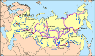
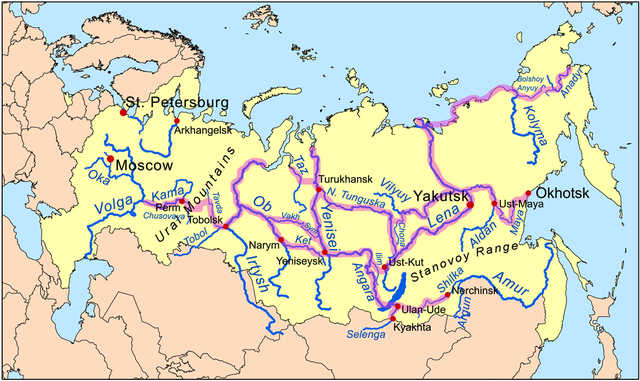
| Description | This is a map of the Siberian River Routes. | ||
| Date | |||
| Source | Own work using Digital Chart of the World data. Routes based on descriptions from Forsyth, James, "A History of the Peoples of Siberia",1992. | ||
| Author | Kmusser | ||
| Other versions |
|

I, the copyright holder of this work, hereby publish it under the following license:
This file is licensed under the Creative Commons Attribution-Share Alike 3.0 Unported license.
- You are free:
- to share – to copy, distribute and transmit the work
- to remix – to adapt the work
- Under the following conditions:
- attribution – You must give appropriate credit, provide a link to the license, and indicate if changes were made. You may do so in any reasonable manner, but not in any way that suggests the licensor endorses you or your use.
- share alike – If you remix, transform, or build upon the material, you must distribute your contributions under the same or compatible license as the original.
File history
Click on a date/time to view the file as it appeared at that time.
| Date/Time | Thumbnail | Dimensions | User | Comment | |
|---|---|---|---|---|---|
| current | 15:13, 30 November 2009 | | 1,200 × 715 (510 KB) | Kmusser | extend NE route, add Stanovoy label |
| 18:32, 24 November 2009 |  | 1,200 × 715 (503 KB) | Kmusser | Added route in far NE. | |
| 21:34, 5 January 2009 |  | 1,200 × 715 (492 KB) | Kmusser | corrections to Amur route | |
| 14:15, 18 November 2008 |  | 1,200 × 715 (490 KB) | Kmusser | added Ural label | |
| 21:57, 17 November 2008 |  | 1,000 × 596 (378 KB) | Kmusser | Expanded | |
| 20:34, 12 November 2008 |  | 800 × 477 (258 KB) | Kmusser | {{Information |Description=This is a map of the Siberian River Routes. |Source=Own work using http://www.maproom.psu.edu/dcw/ Digital Chart of the World data. |Date=November 12, 2008 |Author=Kmusser |Perm |
File usage
The following pages on the English Wikipedia use this file (pages on other projects are not listed):
Global file usage
The following other wikis use this file:
- Usage on ar.wikipedia.org
- Usage on ca.wikipedia.org
- Usage on cs.wikipedia.org
- Usage on da.wikipedia.org
- Usage on de.wikipedia.org
- Usage on el.wikipedia.org
- Usage on eo.wikipedia.org
- Usage on es.wikipedia.org
- Usage on fi.wikipedia.org
- Usage on fr.wikipedia.org
- Usage on he.wikipedia.org
- Usage on hy.wikipedia.org
- Usage on it.wikipedia.org
- Usage on ja.wikipedia.org
- Usage on ja.wikibooks.org
- Usage on ko.wikipedia.org
- Usage on mk.wikipedia.org
- Usage on nl.wikipedia.org
- Usage on ru.wikipedia.org
- Usage on sl.wikipedia.org
- Usage on tr.wikipedia.org
- Usage on uk.wikipedia.org
- Usage on vi.wikipedia.org
- Usage on zh.wikipedia.org