Akkışla | |
|---|---|
District and municipality | |
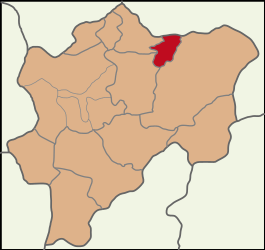
 Map showing Akkışla District in Kayseri Province | |
| Coordinates: 39°00′N 36°10′E / 39.000°N 36.167°E | |
| Country | Turkey |
| Province | Kayseri |
| Government | |
| • Mayor | Ayhan Arslan (AKP) |
| Area | 371 km2 (143 sq mi) |
| Elevation | 1,370 m (4,490 ft) |
| Population (2022)[1] | 5,563 |
| • Density | 15/km2 (39/sq mi) |
| Time zone | UTC+3 (TRT) |
| Postal code | 38830 |
| Area code | 0352 |
| Website | www |
Akkışla is a municipality and district of Kayseri Province, Turkey.[2] Its area is 371 km2,[3] and its population is 5,563 (2022).[1]
Composition[edit]
There are 15 neighbourhoods in Akkışla District:[4]
- Akin
- Alevkışla
- Ganişeyh
- Girinci
- Gömürgen
- Gömürgen Yeni
- Gümüşsu
- Kululu
- Manavuz
- Ortaköy
- Şen
- Uğurlu
- Yeni
- Yeşil
- Yukarı
References[edit]
- ^ a b "Address-based population registration system (ADNKS) results dated 31 December 2022, Favorite Reports" (XLS). TÜİK. Retrieved 19 September 2023.
- ^ Büyükşehir İlçe Belediyesi, Turkey Civil Administration Departments Inventory. Retrieved 19 September 2023.
- ^ "İl ve İlçe Yüz ölçümleri". General Directorate of Mapping. Retrieved 19 September 2023.
- ^ Mahalle, Turkey Civil Administration Departments Inventory. Retrieved 19 September 2023.
External links[edit]
- District governor's official website (in Turkish)
- District municipality's official website (in Turkish)


