Introduction
Peru, officially the Republic of Peru, is a country in western South America. It is bordered in the north by Ecuador and Colombia, in the east by Brazil, in the southeast by Bolivia, in the south by Chile, and in the south and west by the Pacific Ocean. Peru is a megadiverse country with habitats ranging from the arid plains of the Pacific coastal region in the west to the peaks of the Andes mountains extending from the north to the southeast of the country to the tropical Amazon basin rainforest in the east with the Amazon River. Peru has a population of over 32 million, and its capital and largest city is Lima. At 1,285,216 km2 (496,225 sq mi), Peru is the 19th largest country in the world, and the third largest in South America. Peruvian territory was home to several cultures during the ancient and medieval periods, and has one of the longest histories of civilization of any country, tracing its heritage back to the 10th millennium BCE. Notable pre-colonial cultures and civilizations include the Caral–Supe civilization (the earliest civilization in the Americas and considered one of the cradles of civilization), the Nazca culture, the Wari and Tiwanaku empires, the Kingdom of Cusco, and the Inca Empire, the largest known state in the pre-Columbian Americas. The Spanish Empire conquered the region in the 16th century and Charles V established a viceroyalty with the official name of the Kingdom of Peru that encompassed most of its South American territories, with its capital in Lima. Higher education started in the Americas with the official establishment of the National University of San Marcos in Lima in 1551. Peru's population includes Mestizos, Amerindians, Europeans, Africans and Asians. The main spoken language is Spanish, although a significant number of Peruvians speak Quechuan languages, Aymara, or other Indigenous languages. This mixture of cultural traditions has resulted in a wide diversity of expressions in fields such as art, cuisine, literature, and music. (Full article...) Entries here consist of Good and Featured articles, which meet a core set of high editorial standards.
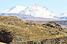
Tutupaca is a volcano in the region of Tacna in Peru. It is part of the Peruvian segment of the Central Volcanic Zone, one of several volcanic belts in the Andes. Tutupaca consists of three overlapping volcanoes formed by lava flows and lava domes made out of andesite and dacite, which grew on top of older volcanic rocks. The highest of these is usually reported to be 5,815 metres (19,078 ft) tall and was glaciated in the past. Several volcanoes in Peru have been active in recent times, including Tutupaca. Their volcanism is caused by the subduction of the Nazca Plate beneath the South America Plate. One of these volcanoes collapsed in historical time, probably in 1802, generating a large debris avalanche with a volume likely exceeding 0.6–0.8 cubic kilometres (0.14–0.19 cu mi) and a pyroclastic flow. The associated eruption was among the largest in Peru for which there are historical records. The volcano became active about 700,000 years ago, and activity continued into the Holocene, but whether there were historical eruptions was initially unclear; some eruptions were instead attributed to the less eroded Yucamane volcano. The Peruvian government plans to monitor the volcano for future activity. Tutupaca features geothermal manifestations with fumaroles and hot springs. (Full article...)Selected image Photo credit: Ericbronder
The district of Santa Anita is one of 43 districts in the city of Lima, which are administered by the Metropolitan Lima Municipal Council. Each district has its own council and mayor (Spanish: Municipalidad distrital). The town hall in each district is the seat of the district council. (more...) Selected battleThe Siege of Cuzco (May 6, 1536 – March 1537) was the ten month siege of the city of Cuzco by the army of Inca Emperor Manco Inca Yupanqui against a garrison of Spanish conquistadors and Indian auxiliaries led by Hernando Pizarro. An Spaniard expedition led by Francisco Pizarro had captured the Inca capital of Cuzco on November 15, 1533 after defeating an Inca army headed by general Quisquis. The following month, the conquistadors supported the coronation as Inca emperor of Manco Inca to facilitate their control over the empire. However, real power rested with the Spaniards who frequently humiliated Manco Inca and imprisoned him after an attempted escape in November 1535. After his release in January 1536, Manco Inca managed to leave Cuzco on April 18 promising the Spanish commander, Hernando Pizarro, to bring back a large gold statue when in fact he was already preparing a rebellion. (more...) In this month
General imagesThe following are images from various Peru-related articles on Wikipedia.
Selected article -The Ecuadorian–Peruvian territorial dispute was a territorial dispute between Ecuador and Peru, which, until 1928, also included Colombia. The dispute had its origins on each country's interpretation of what Real Cedulas Spain used to precisely define its colonial territories in the Americas. After independence, all of Spain's colonial territories signed and agreed to proclaim their limits in the basis of the principle of uti possidetis juris, which regarded the Spanish borders of 1810 as the borders of the new republics. However, conflicting claims and disagreements between the newly formed countries eventually escalated to the point of armed conflicts on several occasions. The dispute de jure had come to an end in the aftermath of the Ecuadorian–Peruvian War with the signing of the Rio de Janeiro Protocol on January 29, 1942. However, this treaty was also questioned, and the two countries went to war on two more occasions: the Paquisha War in 1981, and the Cenepa War in 1995. Tensions subsided but persisted over the next three years. On October 26, 1998, Ecuador and Peru signed a comprehensive peace accord that established a framework for ending a border dispute. Formal demarcation of border regions started on May 13, 1999. The agreement was ratified without opposition by the congresses of both nations, finally bringing a definitive end to the dispute. (Full article...)Did you know (auto-generated) -
CategoriesRelated portalsSelected quote -
Basic facts & figuresMore did you know...
Peru TopicsRecognized contentFeatured articlesFeatured listsGood articles
WikiProjectsThings you can do
New articlesThis list was generated from these rules. Questions and feedback are always welcome! The search is being run daily with the most recent ~14 days of results. Note: Some articles may not be relevant to this project.
Rules | Match log | Results page (for watching) | Last updated: 2024-04-14 22:18 (UTC) Note: The list display can now be customized by each user. See List display personalization for details.
Associated WikimediaThe following Wikimedia Foundation sister projects provide more on this subject:
Discover Wikipedia using portals | ||||||||||||||||


