The Mauritania Portal - بوابة موريتانيا
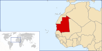
Mauritania, officially the Islamic Republic of Mauritania (Arabic: الجمهورية الإسلامية الموريتانية, al-Jumhūrīyah al-Islāmīyah al-Mūrītānīyah), is a sovereign country in Northwest Africa. It is bordered by the Atlantic Ocean to the west, Western Sahara to the north and northwest, Algeria to the northeast, Mali to the east and southeast, and Senegal to the southwest. By land area, Mauritania is the 11th-largest country in Africa and the 28th-largest in the world, and 90% of its territory is situated in the Sahara. Most of its population of approximately 4.3 million lives in the temperate south of the country, with roughly one-third concentrated in the capital and largest city, Nouakchott, located on the Atlantic coast. The country's name derives from the ancient Berber kingdom of Mauretania, located in North Africa within the ancient Maghreb. Berbers occupied what is now Mauritania beginning in the third century AD. Arabs under the Umayyad Caliphate conquered the area in the late seventh century, bringing Islam, Arab culture, and the Arabic language. In the early 20th century, Mauritania was colonized by France as part of French West Africa. It achieved independence in 1960, but has since experienced recurrent coups and periods of military dictatorship. The most recent coup, in 2008, was led by General Mohamed Ould Abdel Aziz, who won subsequent presidential elections in 2009 and 2014. He was succeeded by Mohamed Ould Ghazouani following the 2019 elections, which were considered Mauritania's first peaceful transition of power since independence. Mauritania is culturally and politically part of the Arab world; it is a member of the Arab League and Arabic is the official language. The official religion is Islam, and almost all inhabitants are Sunni Muslims. Despite its prevailing Arab identity, Mauritanian society is multiethnic; the Bidhan, or so-called "white moors", make up 30% of the population, while the Haratin, or so-called "black moors", comprise 40%. Both groups reflect a fusion of Arab-Berber ethnicity, language, and culture. The remaining 30% of the population comprises various sub-Saharan ethnic groups. Despite an abundance of natural resources, including iron ore and petroleum, Mauritania remains poor; its economy is based primarily on agriculture, livestock, and fishing. Mauritania is generally seen as having a poor human rights record, and is particularly censured for the perpetuation of slavery as an institution within Mauritanian society, with an estimation by the 2018 Global Slavery Index of about 90,000 slaves in the country (or 2.1% of the population). (Full article...) Selected article - Presidential elections were held in Mauritania on 11 March 2007. As no candidate received a majority of the votes, a second round was held on 25 March between the top two candidates, Sidi Ould Cheikh Abdallahi and Ahmed Ould Daddah. Abdallahi won the second round with about 53% of the vote and took office in April. The 2007 election followed a military coup in August 2005 that ousted long-time President Maaouya Ould Sid'Ahmed Taya. The head of the junta, Ely Ould Mohamed Vall, said that he and the other members of the junta would not run for president in the election, which marks the last stage of the transition to civilian rule. (Full article...)This is a Good article, an article that meets a core set of high editorial standards.
Ten Hamadi (Arabic: تن حمادي) or Tenhemad is a village and rural commune in southern Mauritania, in the Aïoun El Atrouss department of the Hodh El Gharbi region. In 2000, the commune had a population of 2,264, of which 155 lived in the village of Ten Hamadi itself, approximately 17 kilometres (11 mi) southwest of the main town and departmental capital of Aïoun El Atrouss. The population estimate in 2007 was 3,686, spread over 16 villages. The northern part of the commune is hilly but relatively favorable to agriculture, while the southern part is flat and characterized by sand dunes. Situated at the southern boundary of the Sahara-Sahel region of southern Mauritania, the climate is generally hot and dry. (Full article...)CategoriesGeneral images -The following are images from various Mauritania-related articles on Wikipedia.
Related portalsWikiProjects
Topics in MauritaniaCities and towns
CommunesAssociated WikimediaThe following Wikimedia Foundation sister projects provide more on this subject:
Discover Wikipedia using portals
Purge server cache
| ||||||||||||||||||||||||||||||||||||||||||||||||||||||||||||||||


